|
|
Antenna Structure Registration 1012836 |
 |
Registration Info | Registration Number: 1012836 |
| File Number: A1075163 |
| FAA Study: 97-AWP-1265-OE |
| FAA Issue Date: 06/05/1997 |
| Status: Constructed |
| Date Constructed: 01/01/1986 |
| NEPA: N |
Structure Info
| Structure Type: GTOWER |
| Structure Coordinates: 34-13-55.0 N 118-4-21.0 W (NAD 83) |
| Structure Coordinates: 34-13-55.0 N 118-04-17.8 W (Converted to NAD 27) |
| Structure Address: 123 Cbs Lane |
| Structure City: Mount Wilson, CA |
| Structure County: Los Angeles County |
| Painting & Lighting Info |
FCC Paragraph(s): 1, 3, 6, 15, 21 |
Remarks: RED LIGHTS/PAINT - SPEC. COND: PARAGRAPH 6 MODIFIED TO REQUIRE LIGHTS AT THE TWO-THIRDS LEVEL ONLY. PARAGRAPHS 15 MODIFIED TO REQUIRE LIGHTS AT THE FIVE-SIXTHS LEVEL ONLY. SHIELDING MUST BE PLACED ON LIGHT UNDERSIDE TO AVOID INTERFERENCE TO OBSERVATORY |
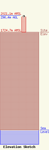
| Elevation Info |
Site Elevation: 1724.7 meters (5658 ft) |
| Height of Structure: 274.2 meters (900 feet) |
| Overall Height Above Ground: 296.4 meters (972 feet) |
| Overall Height Above Mean Sea Level: 2021.1 meters (6631 feet) |
| Owner Info | American Towers LLC
10 Presidential Way
Woburn, MA 01801
(781) 926-4500
faa-fcc@americantower.com |
| Contact Info | American Towers, LLC.
10 Presidential Way
Woburn, MA 01801
(781) 926-4500
faa-fcc@americantower.com |
