
FCCInfo.com
A Service of Cavell, Mertz & Associates, Inc.
(855) FCC-INFO
|
|
WRNN-TV from 12/22/1983 |
RF spectrum relinquished in the spectrum auction Virtual Channel 48 |
|
||||||||||||||||
|
|
WRNN-TV is a channel sharing guest of WWOR-TV, Secaucus, New Jersey Repacking Information: Channel 48 was relinquished in the spectrum auction Status: License Application Accepted: 05/03/2018 License Expires: 06/01/2023 File Number: 0000053803 FCC Website Links: LMS Facility Details This Application Other WRNN-TV Applications Including Superseded Applications Mailing Address Correspondence for WRNN-TV Correspondence related to application 0000053803 Service Contour - Open Street Map or USGS Map (41 dBu) Service Contour - KML / Google Earth (41 dBu) Public Inspection Files Rabbit Ears Info Search for WRNN-TV Site Location: 40-42-46.8 N 74-00-47.3 W (NAD 83) Site Location: 40-42-46.4 N 74-00-48.8 W (Converted to NAD 27) ERP: 57.8 kW Polarization: Elliptically polarized HAAT: 520.0 m (1706 ft.) Electrical Beam Tilt: 1.0 degree R/C AGL: 526.1 m (1726 ft.) R/C AMSL: 530.4 m (1740 ft.) Site Elevation: 4.3 m. (14 ft.) Height Overall*: 546.2 m (1792 ft.) (* As Filed In This Application, may differ from ASR Data, Below.) Directional Antenna - Antenna Make/Model: R.F. Systems PEP40E Antenna ID: 1003467 Polarization: Elliptically polarized | ||||||||||||||||||
| Antenna Data for Antenna Id: 1003467 WRNN-TV DT File: -0000053803 R.F. Systems - PEP40E Service: DT Standard Pattern: N | 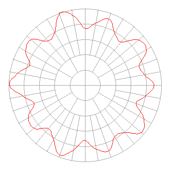 | ||||||||||||||||||
| Azimuth | Ratio | Azimuth | Ratio | Azimuth | Ratio | Azimuth | Ratio | ||||||||||||
| 0 | 0.741 | 10 | 0.822 | 20 | 0.916 | 30 | 0.778 | ||||||||||||
| 40 | 0.735 | 50 | 0.917 | 60 | 0.925 | 70 | 0.755 | ||||||||||||
| 80 | 0.789 | 90 | 0.902 | 100 | 0.806 | 110 | 0.710 | ||||||||||||
| 120 | 0.889 | 130 | 0.962 | 140 | 0.806 | 150 | 0.779 | ||||||||||||
| 160 | 0.911 | 170 | 0.851 | 180 | 0.724 | 185 | 0.770 | ||||||||||||
| 190 | 0.865 | 200 | 0.968 | 210 | 0.824 | 220 | 0.741 | ||||||||||||
| 230 | 0.872 | 240 | 0.857 | 250 | 0.707 | 260 | 0.823 | ||||||||||||
| 270 | 0.987 | 280 | 0.890 | 290 | 0.769 | 300 | 0.895 | ||||||||||||
| 310 | 0.919 | 320 | 0.752 | 330 | 0.791 | 340 | 0.983 | ||||||||||||
| 343 | 1.000 | 350 | 0.924 | ||||||||||||||||
Structure Registration Number 1263701 Structure Type: BTWR Registered To: Port Authority of New York and New Jersey Structure Address: One World Trade Center, The Freedom Tower New York, NY County Name: New York County ASR Issued: 12/31/2015 Date Built: 05/10/2013 Site Elevation: 4.3 m (14 ft.) Structure Height: 406.8 m (1335 ft.) Height Overall: 546.2 m (1792 ft.) Overall Height AMSL: 550.5 m (1806 ft.) FAA Determination: 04/04/2008 FAA Study #: 2007-AEA-4397-OE FAA Circular #: 70/7460-1K Paint & Light FAA Chapters: 4, 9, 12 Removed expiration and final dates from determination. Scenario 2./jjs/case#635066 40-42-46.8 N 74-00-47.3 W (NAD 83) 40-42-46.4 N 74-00-48.8 W (Converted to NAD 27) |
800 Westchester Ave S-640 Rye Brook, NY 10573 Phone: 914-417-2700 Limited Liability Company | Title: Chief Operating Officer Date: 05/03/2018 Application Certifier Wrnn License Company, Llc 800 Westchester Ave S-640 Rye Brook, NY 10573 Applicant Ari S. Meltzer Wiley Rein Llp 1776 K Street, N.w. Washington, DC 20006 | |||||||||||||||||
| |||||||||||||||||||