
FCCInfo.com
A Service of Cavell, Mertz & Associates, Inc.
(855) FCC-INFO
|
|
W278DW from 07/26/2004 |
|
|
||||||||||||||||
|
|
W278DW Channel: 278D 103.5 MHz Vineyard Haven, Massachusetts Service: FX - A translator or application for a translator. Facility ID: 140919 Fac. Service: FX Programming Delivery Method: Unspecified Status: License Application Accepted: 01/06/2020 Application Granted: 01/13/2020 File Number: -0000095287 License Expires: 04/01/2022 Application Type: License To Cover FCC Website Links: LMS Facility Details This Application Other W278DW Applications Other W278DW Applications in CDBS Including Superseded Applications Mailing Address Correspondence for W278DW Correspondence related to application -0000095287 Service Contour - Open Street Map or USGS Map (60 dBu) Service Contour - KML / Google Earth (60 dBu) Facility Type: FM STATION Class: D, A Noncommercial educational operating with no more than 10W Site Location: 41-33-31.0 N 70-35-44.0 W (NAD 83) Site Location: 41-33-30.6 N 70-35-45.9 W (Converted to NAD 27) Effective Radiated Power: 0.25 kW Antenna Center HAAT: 0 m Antenna Center AMSL: 141 m (463 ft.) Antenna Center HAG: 139 m (456 ft.) Site Elevation: 2 m. (7 ft.) Height Overall*: 156 m (512 ft.) (* As Filed In This Application, may differ from ASR Data, Below.) Directional Antenna Antenna Make/Model: Kathrein/Scala CA2-FM/CP-2 Antenna ID: 135240 Polarization: H
| ||||||||||||||||||
| Antenna Data for Antenna Id: 135240 W278DW FX File: -0000095287 Kathrein/Scala - CA2-FM/CP-2 Service: FX | 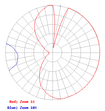 | ||||||||||||||||||
| Azimuth | Ratio | Azimuth | Ratio | Azimuth | Ratio | Azimuth | Ratio | ||||||||||||
| 0 | 1.000 | 10 | 0.100 | 20 | 1.000 | 30 | 1.000 | ||||||||||||
| 40 | 1.000 | 50 | 1.000 | 60 | 1.000 | 70 | 1.000 | ||||||||||||
| 80 | 1.000 | 90 | 1.000 | 100 | 1.000 | 110 | 1.000 | ||||||||||||
| 120 | 1.000 | 130 | 1.000 | 140 | 1.000 | 150 | 1.000 | ||||||||||||
| 160 | 0.999 | 170 | 0.997 | 180 | 0.942 | 190 | 0.852 | ||||||||||||
| 200 | 0.727 | 210 | 0.554 | 220 | 0.365 | 230 | 0.220 | ||||||||||||
| 240 | 0.154 | 250 | 0.087 | 260 | 0.075 | 270 | 0.076 | ||||||||||||
| 280 | 0.094 | 290 | 0.159 | 300 | 0.224 | 310 | 0.379 | ||||||||||||
| 320 | 0.573 | 330 | 0.743 | 340 | 0.863 | 350 | 0.950 | ||||||||||||
Structure Registration Number 1004088 Structure Type: GTOWER Registered To: American Towers LLC Structure Address: 60 Spring Bars Rd (204269) Falmouth, MA County Name: Barnstable County ASR Issued: 02/06/2024 Date Built: 01/01/1990 Site Elevation: 2.4 m (8 ft.) Structure Height: 155.4 m (510 ft.) Height Overall: 155.7 m (511 ft.) Overall Height AMSL: 158.1 m (519 ft.) FAA Determination: 02/24/2023 FAA Study #: 2022-ANE-2522-OE FAA Circular #: 70/7460-1L Paint & Light FAA Chapters: 4, 8, 12 OM&L to remain the same as prior studies = A MED-DUAL SYSTEM 41-33-32.2 N 70-35-43.5 W (NAD 83) 41-33-31.8 N 70-35-45.4 W (Converted to NAD 27) |
253 Old Stockbridge Road Lenox, MA 01240 Phone: 917-846-3930 Limited Liability Company | Title: President Date: 01/06/2020 Application Certifier CODCOMM, INC. Codcomm, Inc. 243 South Street Hyannis, MA 02601 Applicant John Garabedian Codcomm, Inc. 24 Fairview Drive Southborough, MA 01772 President | |||||||||||||||||