
FCCInfo.com
A Service of Cavell, Mertz & Associates, Inc.
(855) FCC-INFO
|
|
|
|
|
||||||||||||||||
|
|
W228DY Channel: 228D 93.5 MHz New Brunswick, New Jersey Service: FX - A translator or application for a translator. Facility ID: 201019 Fac. Service: FX Programming Delivery Method: Unspecified Status: License Application Accepted: 07/16/2021 Application Granted: 08/30/2021 File Number: -0000153009 License Expires: 06/01/2022 Application Type: License To Cover FCC Website Links: LMS Facility Details This Application Other W228DY Applications Other W228DY Applications in CDBS Including Superseded Applications Mailing Address Correspondence for W228DY Correspondence related to application -0000153009 Service Contour - Open Street Map or USGS Map (60 dBu) Service Contour - KML / Google Earth (60 dBu) Facility Type: FM STATION Class: D, A Noncommercial educational operating with no more than 10W Site Location: 40-28-37.4 N 74-29-31.6 W (NAD 83) Site Location: 40-28-37.0 N 74-29-33.0 W (Converted to NAD 27) Effective Radiated Power: 0 kW Horiz. ; 0.25 kW Vert. Antenna Center HAAT: 0 m Antenna Center AMSL: 0 m Horiz.; 169 m Vert. Antenna Center HAG: 0 m Horiz.; 134 m Vert. Site Elevation: 35 m. (115 ft.) Height Overall*: 155 m (509 ft.) (* As Filed In This Application, may differ from ASR Data, Below.) Directional Antenna Antenna Make/Model: Scala CL-FM-V- Custom Antenna ID: 130438 Polarization: H
| ||||||||||||||||||
| Antenna Data for Antenna Id: 130438 W228DY FX File: -0000153009 Scala - CL-FM-V- Custom Service: FX Pattern and Field Values Include a 230° Clockwise Rotation | 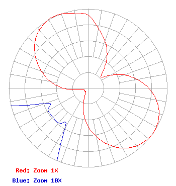 | ||||||||||||||||||
| Azimuth | Ratio | Azimuth | Ratio | Azimuth | Ratio | Azimuth | Ratio | ||||||||||||
| 0 | 0.919 | 10 | 0.763 | 20 | 0.629 | 30 | 0.483 | ||||||||||||
| 40 | 0.320 | 50 | 0.214 | 60 | 0.320 | 70 | 0.483 | ||||||||||||
| 80 | 0.629 | 90 | 0.763 | 100 | 0.876 | 110 | 0.954 | ||||||||||||
| 120 | 0.994 | 125 | 1.000 | 130 | 0.994 | 140 | 0.954 | ||||||||||||
| 150 | 0.876 | 160 | 0.763 | 170 | 0.629 | 180 | 0.483 | ||||||||||||
| 190 | 0.320 | 200 | 0.136 | 210 | 0.058 | 220 | 0.058 | ||||||||||||
| 230 | 0.058 | 240 | 0.058 | 250 | 0.058 | 260 | 0.136 | ||||||||||||
| 270 | 0.320 | 280 | 0.483 | 290 | 0.629 | 300 | 0.763 | ||||||||||||
| 310 | 0.876 | 320 | 0.954 | 330 | 0.994 | 335 | 1.000 | ||||||||||||
| 340 | 0.994 | 350 | 0.954 | ||||||||||||||||
Structure Registration Number 1045877 [ASR Heights Differ from W228DY Application] Structure Type: LTOWER Registered To: American Towers LLC Structure Address: 78 Veronica Ave (203688) Franklin Township, NJ County Name: Somerset County ASR Issued: 01/05/2018 Date Built: 02/01/2013 Site Elevation: 35.4 m (116 ft.) Structure Height: 154 m (505 ft.) Height Overall: 154.5 m (507 ft.) Overall Height AMSL: 189.9 m (623 ft.) FAA Determination: 12/21/2017 FAA Study #: 2017-AEA-13112-OE FAA Circular #: 70/7460-1L Paint & Light FAA Chapters: 4, 8, 12 PRIOR STUDY 2010-AEA-2369-OE 40-28-37.0 N 74-29-31.5 W (NAD 83) 40-28-36.6 N 74-29-32.9 W (Converted to NAD 27) |
3033 Riviera Drive Suite 200 Naples, FL 34103 Phone: 239-263-5000 Limited Liability Company | Title: Cfo Date: 07/16/2021 Application Certifier BEASLEY MEDIA GROUP LICENSES, LLC Beasley Media Group Licenses, Llc 3033 Riviera Drive Suite 200 Naples, FL 34103 Applicant SALLY A BUCKMAN, ESQ Lerman Senter Pllc 2001 L Street Nw Suite 400 Washington, DC 20036 BERT GOLDMAN, Goldman Goldman Engineering Management 560 Perkins Way Auburn, CA 95603 TECHNICAL CONSULTANT | |||||||||||||||||