
FCCInfo.com
A Service of Cavell, Mertz & Associates, Inc.
(855) FCC-INFO
|
|
|
|
|
||||||||||||||||
|
|
W296EA Channel: 296D 107.1 MHz Manchester Township, Pennsylvania Service: FX - A translator or application for a translator. Facility ID: 200873 Fac. Service: FX Programming Delivery Method: Unspecified Status: License Application Accepted: 09/17/2021 Application Granted: 10/13/2021 File Number: -0000159548 License Expires: 08/01/2022 Application Type: License To Cover FCC Website Links: LMS Facility Details This Application Other W296EA Applications Other W296EA Applications in CDBS Including Superseded Applications Mailing Address Correspondence for W296EA Correspondence related to application -0000159548 Service Contour - Open Street Map or USGS Map (60 dBu) Service Contour - KML / Google Earth (60 dBu) Facility Type: FM STATION Class: D, A Noncommercial educational operating with no more than 10W Site Location: 40-01-37.0 N 76-36-01.0 W (NAD 83) Site Location: 40-01-36.6 N 76-36-02.1 W (Converted to NAD 27) Effective Radiated Power: 0.25 kW Antenna Center HAAT: 0 m Antenna Center AMSL: 382.5 m (1255 ft.) Antenna Center HAG: 106.7 m (350 ft.) Site Elevation: 275.8 m. (905 ft.) Height Overall*: 135.6 m (445 ft.) (* As Filed In This Application, may differ from ASR Data, Below.) Directional Antenna Antenna Make/Model: NIC BKG77-3 0.75 WAVE Antenna ID: 132041 Polarization: H
| ||||||||||||||||||
| Antenna Data for Antenna Id: 132041 W296EA FX File: -0000159548 NIC - BKG77-3 0.75 WAVE Service: FX | 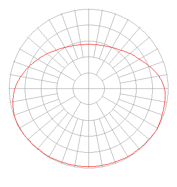 | ||||||||||||||||||
| Azimuth | Ratio | Azimuth | Ratio | Azimuth | Ratio | Azimuth | Ratio | ||||||||||||
| 0 | 0.553 | 10 | 0.558 | 20 | 0.571 | 30 | 0.594 | ||||||||||||
| 40 | 0.628 | 50 | 0.682 | 60 | 0.738 | 70 | 0.815 | ||||||||||||
| 80 | 0.897 | 90 | 0.953 | 100 | 0.973 | 110 | 0.983 | ||||||||||||
| 120 | 1.000 | 130 | 0.992 | 140 | 0.988 | 150 | 0.988 | ||||||||||||
| 160 | 0.983 | 170 | 0.983 | 180 | 0.983 | 190 | 0.983 | ||||||||||||
| 200 | 0.983 | 210 | 0.988 | 220 | 0.988 | 230 | 0.992 | ||||||||||||
| 240 | 1.000 | 250 | 0.991 | 260 | 0.963 | 270 | 0.923 | ||||||||||||
| 280 | 0.862 | 290 | 0.797 | 300 | 0.731 | 310 | 0.676 | ||||||||||||
| 320 | 0.628 | 330 | 0.594 | 340 | 0.571 | 350 | 0.558 | ||||||||||||
Structure Registration Number 1024692 Structure Type: TOWER Registered To: VB Nimbus, LLC Structure Address: 1.6 Mi Nne Hellam, PA County Name: York County ASR Issued: 10/13/2020 Date Built: 05/01/1979 Site Elevation: 275.8 m (905 ft.) Structure Height: 134.7 m (442 ft.) Height Overall: 135.6 m (445 ft.) Overall Height AMSL: 411.4 m (1350 ft.) FAA Determination: 03/21/1979 FAA Study #: 77-AEA-1282-OE Paint & Light FAA Chapters: 1, 3, 12, 21 RED LIGHTS/PAINT 40-01-37.0 N 76-36-01.0 W (NAD 83) 40-01-36.6 N 76-36-02.1 W (Converted to NAD 27) |
1125 Colorado Street Allentown, PA 18101 Phone: 610-434-4801 Limited Liability Company | Title: Exective Vice President And General Counsel Date: 09/17/2021 Application Certifier RADIO LICENSE HOLDING SRC LLC Radio License Holding Src Llc 3280 Peachtree Road, Nw Suite 2200 Atlanta, GA 30305 Applicant Mark Lipp Fletcher Heald & Hildreth Plc 1300 N. 17th Street Suite 1100 Arlington, VA 22209 Attorney Erik C Swanson, PE Hatfield & Dawson 9500 Greenwood Ave N Seattle, WA 98103 Consulting Engineer | |||||||||||||||||