
FCCInfo.com
A Service of Cavell, Mertz & Associates, Inc.
(855) FCC-INFO
|
|
W264DH from 01/14/2014 |
|
|
||||||||||||||||
|
|
W264DH Channel: 228D 93.5 MHz Eatontown, New Jersey Service: FX - A translator or application for a translator. Facility ID: 156685 Fac. Service: FX Programming Delivery Method: Unspecified Status: Construction Permit Application Accepted: 08/25/2023 Application Granted: 09/18/2023 File Number: -0000219930 W264DH CP Expires: 09/18/2026 Application Type: Minor Modification FCC Website Links: LMS Facility Details This Application Other W264DH Applications Other W264DH Applications in CDBS Including Superseded Applications Mailing Address Correspondence for W264DH Correspondence related to application -0000219930 Service Contour - Open Street Map or USGS Map (60 dBu) Service Contour - KML / Google Earth (60 dBu) Facility Type: FM STATION Class: D, A Noncommercial educational operating with no more than 10W Site Location: 39-59-51.1 N 74-10-18.9 W (NAD 83) Site Location: 39-59-50.7 N 74-10-20.4 W (Converted to NAD 27) Effective Radiated Power: 0.25 kW Antenna Center HAAT: 74.9 m Horiz.; 0 m Vert. Antenna Center AMSL: 93.6 m (307 ft.) Antenna Center HAG: 76.2 m (250 ft.) Site Elevation: 17.4 m. (57 ft.) Height Overall*: 94.4 m (310 ft.) (* As Filed In This Application, may differ from ASR Data, Below.) Directional Antenna Antenna Make/Model: Propagation System Inc FML-1-DA Antenna ID: 81205 Polarization: H
| ||||||||||||||||||
| Antenna Data for Antenna Id: 81205 W264DH FX File: -0000219930 Propagation System Inc - FML-1-DA Service: FX | 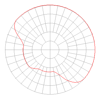 | ||||||||||||||||||
| Azimuth | Ratio | Azimuth | Ratio | Azimuth | Ratio | Azimuth | Ratio | ||||||||||||
| 0 | 1.000 | 10 | 1.000 | 20 | 1.000 | 30 | 1.000 | ||||||||||||
| 40 | 1.000 | 50 | 1.000 | 60 | 1.000 | 70 | 1.000 | ||||||||||||
| 80 | 1.000 | 90 | 1.000 | 100 | 1.000 | 110 | 1.000 | ||||||||||||
| 120 | 1.000 | 130 | 1.000 | 140 | 0.950 | 150 | 0.800 | ||||||||||||
| 160 | 0.600 | 170 | 0.500 | 180 | 0.500 | 190 | 0.500 | ||||||||||||
| 200 | 0.500 | 210 | 0.500 | 220 | 0.550 | 230 | 0.600 | ||||||||||||
| 240 | 0.600 | 250 | 0.600 | 260 | 0.600 | 270 | 0.600 | ||||||||||||
| 280 | 0.600 | 290 | 0.700 | 300 | 0.900 | 310 | 1.000 | ||||||||||||
| 320 | 1.000 | 330 | 1.000 | 340 | 1.000 | 350 | 1.000 | ||||||||||||
Structure Registration Number 1044747 Structure Type: GTOWER Registered To: CTI Towers Assets III, LLC Structure Address: 1470 Hooper Ave Toms River, NJ County Name: Ocean County ASR Issued: 01/28/2021 Date Built: 01/01/1974 Site Elevation: 17.4 m (57 ft.) Structure Height: 94.4 m (310 ft.) Height Overall: 94.4 m (310 ft.) Overall Height AMSL: 111.8 m (367 ft.) FAA Determination: 02/12/2015 FAA Study #: 2015-AEA-619-OE Paint & Light FAA Chapters: A1, H, 3, 11, 21, 23 PRIOR STUDY 2008-AEA-4724-OE 39-59-51.1 N 74-10-18.9 W (NAD 83) 39-59-50.7 N 74-10-20.4 W (Converted to NAD 27) |
201 Main Street Allenhurst, NJ 07711 Phone: 732-751-1119 Limited Liability Company | Title: Ceo Date: 08/25/2023 Application Certifier PRESS COMMUNICATIONS, L.L.C. Press Communications, L.l.c. 201 Main Street Allenhurst, NJ 07711 Applicant Charles M. Anderson Anderson Associates 5900 Lake Cyrus Drive Hoover, AL 35244 Broadcast Engineering Consultant | |||||||||||||||||