
FCCInfo.com
A Service of Cavell, Mertz & Associates, Inc.
(855) FCC-INFO
|
|
W286BS from 06/10/2009 W286BS from 04/24/2009 W286BS from 06/02/2004 |
|
|
||||||||||||||||
|
|
W286BS Channel: 286D 105.1 MHz Milford, Delaware Service: FX - A translator or application for a translator. Facility ID: 150268 Fac. Service: FX Programming Delivery Method: Unspecified Status: License Application Accepted: 11/30/2011 Application Granted: 12/13/2011 File Number: BLFT-20111130AIL License Expires: 00/00/0000 Prefix Type: This is a license for a translator Application Type: License To Cover FCC Website Links: LMS Facility Details This Application CDBS Application Other W286BS Applications Other W286BS Applications in CDBS Including Superseded Applications Mailing Address Correspondence for W286BS Correspondence related to application BLFT-20111130AIL Service Contour - Open Street Map or USGS Map (60 dBu) Service Contour - KML / Google Earth (60 dBu) Class: D, A Noncommercial educational operating with no more than 10W Site Location: 39-11-36.0 N 75-32-38.0 W (NAD 83) Site Location: 39-11-35.6 N 75-32-39.3 W (Converted to NAD 27) Effective Radiated Power: 0 kW Horiz. ; 0.25 kW Vert. Transmitter Output Power: 0.275 kW Antenna Center HAAT: 84.8 m Horiz.; 0 m Vert. Antenna Center AMSL: 0 m Horiz.; 89 m Vert. Antenna Center HAG: 0 m Horiz.; 76 m Vert. Site Elevation: 13 m. (43 ft.) Height Overall*: 98 m (322 ft.) (* As Filed In This Application, may differ from ASR Data, Below.) Directional Antenna Antenna Make/Model: None Antenna ID: 104375 Polarization:
| ||||||||||||||||||
| Antenna Data for Antenna Id: 104375 W286BS FX File: BLFT-20111130AIL None - Service: FX Pattern and Field Values Include a 180° Clockwise Rotation | 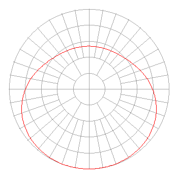 | ||||||||||||||||||
| Azimuth | Ratio | Azimuth | Ratio | Azimuth | Ratio | Azimuth | Ratio | ||||||||||||
| 0 | 0.534 | 10 | 0.535 | 20 | 0.540 | 30 | 0.549 | ||||||||||||
| 40 | 0.566 | 50 | 0.592 | 60 | 0.630 | 70 | 0.679 | ||||||||||||
| 80 | 0.735 | 90 | 0.792 | 100 | 0.845 | 110 | 0.892 | ||||||||||||
| 120 | 0.929 | 130 | 0.956 | 140 | 0.975 | 150 | 0.987 | ||||||||||||
| 160 | 0.995 | 170 | 0.999 | 180 | 1.000 | 190 | 0.999 | ||||||||||||
| 200 | 0.995 | 210 | 0.987 | 220 | 0.975 | 230 | 0.956 | ||||||||||||
| 240 | 0.929 | 250 | 0.892 | 260 | 0.845 | 270 | 0.792 | ||||||||||||
| 280 | 0.735 | 290 | 0.679 | 300 | 0.630 | 310 | 0.592 | ||||||||||||
| 320 | 0.566 | 330 | 0.549 | 340 | 0.540 | 350 | 0.535 | ||||||||||||
Structure Registration Number 1059119 [ASR Heights Differ from W286BS Application] Structure Type: LTOWER Registered To: Delaware Division of Communications Structure Address: 1407 North Dupont Highway Dover, DE County Name: Kent County ASR Issued: 08/09/2023 Date Built: 10/24/2010 Site Elevation: 12.8 m (42 ft.) Structure Height: 91.4 m (300 ft.) Height Overall: 97.5 m (320 ft.) Overall Height AMSL: 110.3 m (362 ft.) FAA Determination: 03/05/2010 FAA Study #: 2010-AEA-537-OE FAA Circular #: 70/7460-1K Paint & Light FAA Chapters: 4, 8, 12 PRIOR STUDY 2001-AEA-1680-OE 39-11-36.0 N 75-32-38.0 W (NAD 83) 39-11-35.6 N 75-32-39.3 W (Converted to NAD 27) |
1076 South Chapel Street Newark, DE 19702 Phone: 240-481-8242 Corporation | Date: 11/30/2011 Application Certifier K-5 COMMUNICATIONS, LLC Po Box 100 Bethel, DE 19931-100 Applicant VINCENT KLEPAC Epcot Broadcasting, Llc Po Box 100 Bethel, DE 19931 MEMBER GREGG P. SKALL, ESQ. Womble Carlyle Sandridge & Rice Pllc 1401 Eye St., Nw Suite 700 Washington, DC 20005-2225 | |||||||||||||||||