
FCCInfo.com
A Service of Cavell, Mertz & Associates, Inc.
(855) FCC-INFO
|
|
WCAI from 10/20/1997 |
|
|
||||||||||||||||
|
|
WCAI Channel: 211B1 90.1 MHz Woods Hole, Massachusetts Service: FM - A full-service FM station or application. Facility ID: 8566 Fac. Service: FM Analog & Digital Status: License Application Accepted: 12/20/2013 Application Granted: 01/16/2014 File Number: BLED-20131220HAX License Expires: 00/00/0000 Prefix Type: This is a license for a noncommercial educational FM station Application Type: License To Cover FCC Website Links: LMS Facility Details This Application CDBS Application Other WCAI Applications Other WCAI Applications in CDBS Including Superseded Applications Mailing Address Correspondence for WCAI Correspondence related to application BLED-20131220HAX Service Contour - Open Street Map or USGS Map (60 dBu) Service Contour - KML / Google Earth (60 dBu) Public Inspection Files Facility Type: NON-COMMERCIAL EDUC. FM Class: B1, A Zone I or I-A station; with 6kW-25kW ERP and a class contour distance 28km-39km Site Location: 41-26-16.4 N 70-36-48.1 W (NAD 83) Site Location: 41-26-16.0 N 70-36-50.0 W (Converted to NAD 27) Effective Radiated Power: 12.5 kW Transmitter Output Power: 4.7 kW Antenna Center HAAT: 73.5 m (241 ft.) Antenna Center AMSL: 80.9 m (265 ft.) Antenna Center HAG: 41 m (135 ft.) Calculated Site Elevation: 39.9 m. (131 ft.) Height Overall*: 62.4 m (205 ft.) (* As Filed In This Application, may differ from ASR Data, Below.) Directional Antenna Antenna Make/Model: DIELECTRIC DCRH4E50P Antenna ID: 115241 Polarization: | ||||||||||||||||||
| Antenna Data for Antenna Id: 115241 WCAI FM File: BLED-20131220HAX DIELECTRIC - DCRH4E50P Service: FM | 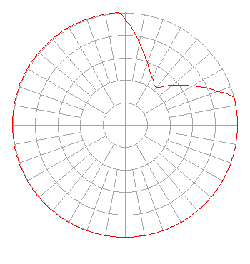 | ||||||||||||||||||
| Azimuth | Ratio | Azimuth | Ratio | Azimuth | Ratio | Azimuth | Ratio | ||||||||||||
| 0 | 0.933 | 10 | 0.741 | 20 | 0.589 | 25 | 0.525 | ||||||||||||
| 30 | 0.479 | 40 | 0.437 | 50 | 0.550 | 60 | 0.692 | ||||||||||||
| 70 | 0.871 | 76 | 1.000 | 80 | 1.000 | 90 | 1.000 | ||||||||||||
| 100 | 1.000 | 110 | 1.000 | 120 | 1.000 | 130 | 1.000 | ||||||||||||
| 140 | 1.000 | 150 | 1.000 | 160 | 1.000 | 170 | 1.000 | ||||||||||||
| 180 | 1.000 | 190 | 1.000 | 200 | 1.000 | 210 | 1.000 | ||||||||||||
| 220 | 1.000 | 230 | 1.000 | 240 | 1.000 | 250 | 1.000 | ||||||||||||
| 260 | 1.000 | 270 | 1.000 | 280 | 1.000 | 290 | 1.000 | ||||||||||||
| 300 | 1.000 | 310 | 1.000 | 320 | 1.000 | 330 | 1.000 | ||||||||||||
| 340 | 1.000 | 350 | 1.000 | 357 | 1.000 | ||||||||||||||
Structure Registration Number 1004416 Structure Type: GTOWER Registered To: American Towers LLC Structure Address: 121 Carroll S Way (10338) Vineyard Haven, MA County Name: Dukes County ASR Issued: 02/23/2024 Date Built: 04/14/2009 Site Elevation: 39.9 m (131 ft.) Structure Height: 60.3 m (198 ft.) Height Overall: 62.5 m (205 ft.) Overall Height AMSL: 102.4 m (336 ft.) FAA Determination: 05/05/2023 FAA Study #: 2023-ANE-1966-OE FAA Circular #: 70/7460-1K Paint & Light FAA Chapters: 3, 4, 5, 12 PRIOR STUDY 2014-ANE-126-OE 41-26-16.2 N 70-36-48.6 W (NAD 83) 41-26-15.8 N 70-36-50.5 W (Converted to NAD 27) |
One Guest Street Boston, MA 02135 | Date: 12/20/2013 Application Certifier WGBH EDUCATIONAL FOUNDATION 1 Guest Street Boston, MA 02135-5000 Applicant JOSEPH M. DAVIS, P.E. Chesapeake Rf Consultants, Llc 207 Old Dominion Road Yorktown, VA 23692 CONSULTING ENGINEER MICHAEL BEDER Covington & Burling Llp | |||||||||||||||||
| |||||||||||||||||||