
FCCInfo.com
A Service of Cavell, Mertz & Associates, Inc.
(855) FCC-INFO
|
|
W248BN from 05/31/1995 |
|
|
||||||||||||||||
|
|
W248BN Channel: 248D 97.5 MHz Alexandria, Virginia Service: FX - A translator or application for a translator. Facility ID: 18863 Fac. Service: FX Programming Delivery Method: Unspecified Status: License Application Accepted: 09/20/2016 Application Granted: 09/30/2016 File Number: BLFT-20160920ACI License Expires: 00/00/0000 Prefix Type: This is a license for a translator Application Type: License To Cover FCC Website Links: LMS Facility Details This Application CDBS Application Other W248BN Applications Other W248BN Applications in CDBS Including Superseded Applications Mailing Address Correspondence for W248BN Correspondence related to application BLFT-20160920ACI Service Contour - Open Street Map or USGS Map (60 dBu) Service Contour - KML / Google Earth (60 dBu) Class: D, A Noncommercial educational operating with no more than 10W Site Location: 38-57-50.4 N 77-06-16.9 W (NAD 83) Site Location: 38-57-50.0 N 77-06-18.0 W (Converted to NAD 27) Effective Radiated Power: 0.25 kW Transmitter Output Power: 0.07 kW Antenna Center HAAT: 0 m Antenna Center AMSL: 286 m (938 ft.) Antenna Center HAG: 213 m (699 ft.) Site Elevation: 73 m. (240 ft.) Height Overall*: 247 m (810 ft.) (* As Filed In This Application, may differ from ASR Data, Below.) Directional Antenna Antenna Make/Model: None Antenna ID: 124831 Polarization:
| ||||||||||||||||||
| Antenna Data for Antenna Id: 124831 W248BN FX File: BLFT-20160920ACI None - Service: FX | 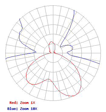 | ||||||||||||||||||
| Azimuth | Ratio | Azimuth | Ratio | Azimuth | Ratio | Azimuth | Ratio | ||||||||||||
| 0 | 0.219 | 10 | 0.186 | 20 | 0.125 | 30 | 0.085 | ||||||||||||
| 40 | 0.034 | 50 | 0.020 | 60 | 0.032 | 70 | 0.042 | ||||||||||||
| 80 | 0.041 | 90 | 0.030 | 100 | 0.061 | 110 | 0.247 | ||||||||||||
| 120 | 0.504 | 130 | 0.728 | 140 | 0.910 | 150 | 1.000 | ||||||||||||
| 160 | 0.956 | 170 | 0.821 | 180 | 0.631 | 190 | 0.555 | ||||||||||||
| 200 | 0.642 | 210 | 0.763 | 220 | 0.803 | 230 | 0.735 | ||||||||||||
| 240 | 0.576 | 250 | 0.344 | 260 | 0.148 | 270 | 0.044 | ||||||||||||
| 280 | 0.047 | 290 | 0.073 | 300 | 0.081 | 310 | 0.085 | ||||||||||||
| 320 | 0.120 | 330 | 0.177 | 340 | 0.214 | 350 | 0.239 | ||||||||||||
Structure Registration Number 1035708 Structure Type: TOWER Registered To: Pinnacle Towers LLC Structure Address: 5202b River Rd Bethesda, MD County Name: Montgomery County ASR Issued: 05/06/2016 Date Built: 12/27/1965 Site Elevation: 73.2 m (240 ft.) Structure Height: 227.1 m (745 ft.) Height Overall: 246.6 m (809 ft.) Overall Height AMSL: 319.8 m (1049 ft.) FAA Determination: 01/25/2012 FAA Study #: 2011-AEA-4561-OE FAA Circular #: 70/7460-1J Paint & Light FAA Chapters: 4, 7, 13 OM&L to remain the same as prior study = 24-HR HI-STROBES 38-57-49.9 N 77-06-17.2 W (NAD 83) 38-57-49.5 N 77-06-18.3 W (Converted to NAD 27) |
11240 Waples Mill Rd Suite 405 Fairfax, VA 22030 Phone: 703-659-0406 | Date: 09/20/2016 Application Certifier METRO RADIO, INC. 3128 Elmendorf Drive Oakton, VA 22124 Applicant LAURA M. MIZRAHI Communications Technologies, Inc. P. O. Box 1130 Marlton, NJ 08053 TECHNICAL CONSULTANT SCOTT WOODWORTH Edinger Associates Pllc 1875 I Street, Nw Suite 500 Washington, DC 20006 | |||||||||||||||||