
FCCInfo.com
A Service of Cavell, Mertz & Associates, Inc.
(855) FCC-INFO
|
|
|
|  |
|
|||||||||||||||
|
|
KZGM Channel: 201C3 88.1 MHz Cabool, Missouri Service: FM - A full-service FM station or application. Facility ID: 172919 Fac. Service: FM Status: License Application Accepted: 03/26/2009 Application Granted: 04/06/2009 File Number: BLED-20090326ADT License Expires: 00/00/0000 Prefix Type: This is a license for a noncommercial educational FM station Application Type: License To Cover FCC Website Links: LMS Facility Details This Application CDBS Application Other KZGM Applications Other KZGM Applications in CDBS Including Superseded Applications Mailing Address Correspondence for KZGM Correspondence related to application BLED-20090326ADT Service Contour - Open Street Map or USGS Map (60 dBu) Service Contour - KML / Google Earth (60 dBu) Public Inspection Files Facility Type: NON-COMMERCIAL EDUC. FM Class: C3, A Zone II station; with 6kW-25kW ERP and a class contour distance 28km-39km Site Location: 37-07-15.2 N 92-00-09.6 W (NAD 83) Site Location: 37-07-15.0 N 92-00-09.0 W (Converted to NAD 27) Effective Radiated Power: 0 kW Horiz. ; 12.5 kW Vert. Transmitter Output Power: 3.675 kW Antenna Center HAAT: 0 m Horiz.; 135 m Vert. Antenna Center AMSL: 0 m Horiz.; 535 m Vert. Antenna Center HAG: 0 m Horiz.; 48 m Vert. Calculated Site Elevation: m. Height Overall*: 61 m (200 ft.) (* As Filed In This Application, may differ from ASR Data, Below.) Directional Antenna Antenna Make/Model: Shivley 6513-2-DA, 2 section, 0.5 wavelength spaced Antenna ID: 81844 Polarization: | ||||||||||||||||||
| Antenna Data for Antenna Id: 81844 KZGM FM File: BLED-20090326ADT Shivley - 6513-2-DA, 2 section, 0.5 wavelength spaced Service: FM | 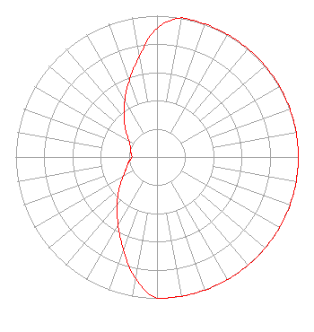 | ||||||||||||||||||
| Azimuth | Ratio | Azimuth | Ratio | Azimuth | Ratio | Azimuth | Ratio | ||||||||||||
| 0 | 0.912 | 10 | 1.000 | 20 | 1.000 | 30 | 1.000 | ||||||||||||
| 40 | 1.000 | 50 | 1.000 | 60 | 1.000 | 70 | 1.000 | ||||||||||||
| 80 | 1.000 | 90 | 1.000 | 100 | 1.000 | 110 | 1.000 | ||||||||||||
| 120 | 1.000 | 130 | 1.000 | 140 | 1.000 | 150 | 1.000 | ||||||||||||
| 160 | 1.000 | 170 | 1.000 | 180 | 1.000 | 190 | 0.876 | ||||||||||||
| 200 | 0.696 | 210 | 0.552 | 220 | 0.439 | 230 | 0.349 | ||||||||||||
| 240 | 0.277 | 250 | 0.231 | 260 | 0.203 | 270 | 0.178 | ||||||||||||
| 280 | 0.188 | 290 | 0.200 | 300 | 0.229 | 310 | 0.288 | ||||||||||||
| 320 | 0.363 | 330 | 0.457 | 340 | 0.575 | 350 | 0.724 | ||||||||||||
Structure Registration Number 1045913 [ASR Heights Differ from KZGM Application] Structure Type: TOWER Registered To: STN Wireless, Inc. Structure Address: Hwy U, 3 Mi. S. Of Us 63 Cabool, MO County Name: Texas County ASR Issued: 08/11/2008 Date Built: 06/20/1992 Site Elevation: 487.4 m (1599 ft.) Structure Height: 54.8 m (180 ft.) Height Overall: 60.6 m (199 ft.) Overall Height AMSL: 548 m (1798 ft.) Paint & Light FAA Chapters: None 37-07-15.0 N 92-00-10.0 W (NAD 83) 37-07-14.8 N 92-00-09.4 W (Converted to NAD 27) |
1211 Ozark Street Cabool, MO 65689 Phone: 417-501-5988 Not-for-Profit | Date: 03/26/2009 Application Certifier REAL COMMUNITY RADIO NETWORK, INC. 1211 Ozark Street Cabool, MO 65689 Applicant RICK JESSE Po Box 347 292 W South Street Hartville, MO 65667-0347 CONSULTING ENGINEER JOHN CRIGLER, ESQUIRE Garvey Schubert Barer | |||||||||||||||||