
FCCInfo.com
A Service of Cavell, Mertz & Associates, Inc.
(855) FCC-INFO
|
|
|
|  |
|
|||||||||||||||
|
|
WTMD Channel: 209B1 89.7 MHz Towson, Maryland Service: FM - A full-service FM station or application. Facility ID: 67461 Fac. Service: FM Analog & Digital Status: License Application Accepted: 07/08/2013 Application Granted: 07/18/2013 File Number: BLED-20130708ABE License Expires: 00/00/0000 Prefix Type: This is a license for a noncommercial educational FM station Application Type: Amendment FCC Website Links: LMS Facility Details This Application CDBS Application Other WTMD Applications Other WTMD Applications in CDBS Including Superseded Applications Mailing Address Correspondence for WTMD Correspondence related to application BLED-20130708ABE Service Contour - Open Street Map or USGS Map (60 dBu) Service Contour - KML / Google Earth (60 dBu) Public Inspection Files History Cards for WTMD Facility Type: NON-COMMERCIAL EDUC. FM Class: B1, A Zone I or I-A station; with 6kW-25kW ERP and a class contour distance 28km-39km Site Location: 39-24-10.4 N 76-36-10.9 W (NAD 83) Site Location: 39-24-10.0 N 76-36-12.0 W (Converted to NAD 27) Effective Radiated Power: 7.4 kW Transmitter Output Power: 3.1 kW Antenna Center HAAT: 122 m (400 ft.) Antenna Center AMSL: 224 m (735 ft.) Antenna Center HAG: 79 m (259 ft.) Calculated Site Elevation: 145 m. (476 ft.) Height Overall*: 85.3 m (280 ft.) (* As Filed In This Application, may differ from ASR Data, Below.) Directional Antenna Antenna Make/Model: Electronics Research Inc. LP-6E-DA-HW Antenna ID: 110743 Polarization: | ||||||||||||||||||
| Antenna Data for Antenna Id: 110743 WTMD FM File: BLED-20130708ABE Electronics Research Inc. - LP-6E-DA-HW Service: FM | 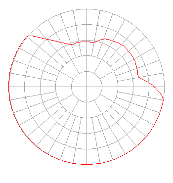 | ||||||||||||||||||
| Azimuth | Ratio | Azimuth | Ratio | Azimuth | Ratio | Azimuth | Ratio | ||||||||||||
| 0 | 0.577 | 10 | 0.577 | 20 | 0.649 | 30 | 0.677 | ||||||||||||
| 40 | 0.703 | 50 | 0.703 | 60 | 0.703 | 70 | 0.690 | ||||||||||||
| 80 | 0.690 | 90 | 0.869 | 100 | 1.000 | 110 | 1.000 | ||||||||||||
| 120 | 1.000 | 130 | 1.000 | 140 | 1.000 | 150 | 1.000 | ||||||||||||
| 160 | 1.000 | 170 | 1.000 | 180 | 1.000 | 190 | 1.000 | ||||||||||||
| 200 | 1.000 | 210 | 1.000 | 220 | 1.000 | 230 | 1.000 | ||||||||||||
| 240 | 1.000 | 250 | 1.000 | 260 | 1.000 | 270 | 1.000 | ||||||||||||
| 280 | 1.000 | 290 | 1.000 | 300 | 1.000 | 310 | 1.000 | ||||||||||||
| 320 | 0.795 | 330 | 0.655 | 340 | 0.577 | 350 | 0.577 | ||||||||||||
Structure Registration Number 1037283 Structure Type: BTWR Registered To: Towson City Center, LLC Structure Address: 1 Olympic Place Towson, MD County Name: Baltimore County ASR Issued: 03/18/2013 Date Built: 06/25/2013 Site Elevation: 145.4 m (477 ft.) Structure Height: 57.9 m (190 ft.) Height Overall: 85.3 m (280 ft.) Overall Height AMSL: 230.7 m (757 ft.) FAA Determination: 09/04/2012 FAA Study #: 2012-AEA-4129-OE FAA Circular #: 70/7460-1H Paint & Light FAA Chapters: 3, 4, 5, 13 OM&L to remain the same as prior study = PAINT/RED LIGHTS 39-24-10.4 N 76-36-10.9 W (NAD 83) 39-24-10.0 N 76-36-12.0 W (Converted to NAD 27) |
2216 North Charles Street Baltimore, MD 21218 Phone: 410-235-1065 Limited Liability Company | Date: 07/08/2013 Application Certifier TOWSON UNIVERSITY 8000 York Road Mc-005 Towson, MD 21252 Applicant WILLIAM J. GETZ Carl T. Jones Corporation 7901 Yarnwood Ct Springfield, VA 22153 CONSULTING ENGINEER STEPHEN M. YASKO Towson University | |||||||||||||||||