
FCCInfo.com
A Service of Cavell, Mertz & Associates, Inc.
(855) FCC-INFO
|
|
DKATA-CD from 07/08/2009 DKATA-CD from 10/03/2005 DKATA-CD from 02/19/1996 DKATA-CD from 07/23/1991 |
Virtual Channel 50 |
|
||||||||||||||||
|
|
Status: License Application Accepted: 09/05/2017 License Expires: 08/01/2022 File Number: -0000029645 FCC Website Links: LMS Facility Details This Application Other DKATA-CD Applications Including Superseded Applications Mailing Address Correspondence for DKATA-CD Correspondence related to application -0000029645 Service Contour - Open Street Map or USGS Map (51 dBu) Service Contour - KML / Google Earth (51 dBu) Public Inspection Files Rabbit Ears Info Search for DKATA-CD Site Location: 32-35-22.0 N 96-58-12.9 W (NAD 83) Site Location: 32-35-21.5 N 96-58-11.9 W (Converted to NAD 27) ERP: 15 kW R/C AGL: 260 m (853 ft.) R/C AMSL: 512.9 m (1683 ft.) Emission Mask: Stringent Site Elevation: 252.9 m. (830 ft.) Height Overall*: 472.7 m (1551 ft.) (* As Filed In This Application, may differ from ASR Data, Below.) Directional Antenna - Antenna Make/Model: MICRO COMMUNICATIONS INC 955318 Antenna ID: 20061 | ||||||||||||||||||
| Antenna Data for Antenna Id: 20061 DKATA-CD DC File: -0000029645 MICRO COMMUNICATIONS INC - 955318 Service: DC Standard Pattern: Y Pattern and Field Values Include a 314° Clockwise Rotation | 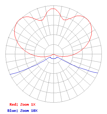 | ||||||||||||||||||
| Azimuth | Ratio | Azimuth | Ratio | Azimuth | Ratio | Azimuth | Ratio | ||||||||||||
| 4 | 0.902 | 14 | 0.756 | 19 | 0.740 | 24 | 0.793 | ||||||||||||
| 34 | 0.947 | 44 | 1.000 | 54 | 0.967 | 64 | 0.872 | ||||||||||||
| 74 | 0.729 | 84 | 0.556 | 94 | 0.378 | 104 | 0.218 | ||||||||||||
| 114 | 0.094 | 124 | 0.021 | 134 | 0.010 | 144 | 0.010 | ||||||||||||
| 154 | 0.010 | 164 | 0.010 | 174 | 0.010 | 184 | 0.010 | ||||||||||||
| 194 | 0.010 | 204 | 0.010 | 214 | 0.010 | 224 | 0.010 | ||||||||||||
| 234 | 0.021 | 244 | 0.094 | 254 | 0.218 | 264 | 0.378 | ||||||||||||
| 274 | 0.556 | 284 | 0.729 | 294 | 0.872 | 304 | 0.967 | ||||||||||||
| 314 | 1.000 | 324 | 0.947 | 334 | 0.793 | 339 | 0.740 | ||||||||||||
| 344 | 0.756 | 354 | 0.902 | 359 | 0.933 | ||||||||||||||
Structure Registration Number 1055009 [ASR Heights Differ from DKATA-CD Application] Structure Type: GTOWER Registered To: American Towers LLC Structure Address: 1360 W. Belt Line Rd. (075253) Cedar Hill, TX County Name: Dallas County ASR Issued: 12/19/2017 Date Built: 11/04/2008 Site Elevation: 252.9 m (830 ft.) Structure Height: 442.9 m (1453 ft.) Height Overall: 487.7 m (1600 ft.) Overall Height AMSL: 740.6 m (2430 ft.) FAA Determination: 12/13/2017 FAA Study #: 2017-ASW-18744-OE Paint & Light FAA Chapters: 1, 3, 10.1, 19.1, 21 PRIOR STUDY 2012-ASW-2206-OE 32-35-22.0 N 96-58-12.9 W (NAD 83) 32-35-21.5 N 96-58-11.9 W (Converted to NAD 27) |
518 Peoples Street Corpus Christi, TX 78401 Phone: 361-883-1763 Limited Liability Company | Title: Member Date: 09/05/2017 Application Certifier MAKO COMMUNICATIONS, LLC Mako Communications, Llc 518 Peoples Street Corpus Christi, TX 78401 Applicant LEE PELTZMAN Shainis & Peltzman 1850m Street, N.w. Suite 240 Washington, DC 20036 JIMMY WILKEN Mako Communications 3406 Brawner Pkwy Corpus Christi, TX 78411 ENGINEER | |||||||||||||||||