|
|
Antenna Structure Registration 1053884 |
 |
Registration Info | Registration Number: 1053884 |
| File Number: A1159178 |
| FAA Study: 87-AEA-2058-OE |
| FAA Issue Date: 03/14/1988 |
| Status: Constructed |
| Date Constructed: 01/01/1950 |
| FAA EMI: N |
| NEPA: N |
Structure Info
| Structure Type: TOWER |
| Structure Coordinates: 41-11-43.0 N 76-58-17.0 W (NAD 83) |
| Structure Coordinates: 41-11-42.7 N 76-58-18.1 W (Converted to NAD 27) |
| Structure Address: Skyline Dr Bald Eagle Mountain |
| Structure City: South Williamsport, PA |
| Structure County: Lycoming County |
| Painting & Lighting Info |
FAA Circular #: 70/7460-1G |
FAA Chapters: 3, 4, 5, 9 |
| Elevation Info |
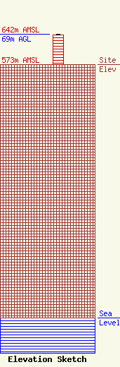
Site Elevation: 573 meters (1880 ft) |
| Height of Structure: 68 meters (223 feet) |
| Overall Height Above Ground: 69 meters (226 feet) |
| Overall Height Above Mean Sea Level: 642 meters (2106 feet) |
| Owner Info | Backyard Broadcasting of Pennsylvania, LLC
1685 Four Mile Drive
Williamsport, PA 17701
(570) 323-8200
vmichael@backyardbroadcasting.com |
| Contact Info | Backyard Broadcasting of Pennsylvania, LLC
1685 Four Mile Drive
Williamsport, PA 17701
Van Michael
(570) 323-8200
vmichael@backyardbroadcasting.com |
