|
|
Antenna Structure Registration 1254100 |
 |
Registration Info | Registration Number: 1254100 |
| File Number: A0723586 |
| FAA Study: 2006-ASO-3069-OE |
| FAA Issue Date: 06/19/2006 |
| Status: Constructed |
| Date Constructed: 04/04/2011 |
| FAA EMI: N |
| NEPA: N |
Structure Info
| Structure Type: TOWER |
| Structure Coordinates: 29-1-30.9 N 81-8-51.4 W (NAD 83) |
| Structure Coordinates: 29-01-30.0 N 81-08-52.2 W (Converted to NAD 27) |
| Structure Address: 1 Mile West Of Intersection Of Pioneer Trail And Sr 44, On Sr 44 |
| Structure City: Deland, FL |
| Structure County: Volusia County |
| Painting & Lighting Info |
FAA Circular #: 70/7460-1K |
FAA Chapters: 4, 6, 12 |
Remarks: Removed expiration date from determination. Scenario 1./jjs/case#635066 |
| Elevation Info |
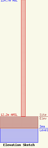
Site Elevation: 12.2 meters (40 ft) |
| Height of Structure: 124 meters (407 feet) |
| Overall Height Above Ground: 124.7 meters (409 feet) |
| Overall Height Above Mean Sea Level: 136.9 meters (449 feet) |
| Owner Info | Mims Community Radio, Inc.
900 Old Mission Rd
New Smyrna Beach, FL 32168
Carol Henry
(386) 427-1095
wpio@gate.net |
