|
|
Antenna Structure Registration 1024640 |
 |
Registration Info | Registration Number: 1024640 |
| File Number: A0981877 |
| Status: Constructed |
| Date Constructed: 08/01/1953 |
| FAA EMI: N |
| NEPA: N |
Structure Info
| Structure Type: TOWER |
| Structure Coordinates: 44-54-24.0 N 94-22-0.0 W (NAD 83) |
| Structure Coordinates: 44-54-24.1 N 94-21-59.1 W (Converted to NAD 27) |
| Structure Address: 75' E Of Hwy 15 .8 Mi N |
| Structure City: Hutchinson, MN |
| Structure County: McLeod County |
| Painting & Lighting Info |
FCC Paragraph(s): 1, 3, 11, 21 |
| Elevation Info |
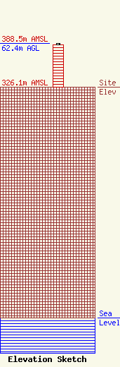
Site Elevation: 326.1 meters (1070 ft) |
| Height of Structure: 60.9 meters (200 feet) |
| Overall Height Above Ground: 62.4 meters (205 feet) |
| Overall Height Above Mean Sea Level: 388.5 meters (1275 feet) |
| Owner Info | IOWA CITY BROADCASTING COMPANY, INC.
5100 W 36TH STREET
16683
MINNEAPOLIS, MN 55416-0683
(952) 913-4017
dawn@sciarrinolaw.com |
| Contact Info | SCIARRINO & SHUBERT, PLLC
5425 TREE LINE DRIVE
CENTREVILLE, VA 20120
(202) 256-9551
dawn@sciarrinolaw.com |
