|
|
Antenna Structure Registration 1035143 |
 |
Registration Info | Registration Number: 1035143 |
| File Number: A1206895 |
| FAA Study: N/A |
| Status: Constructed |
| Date Constructed: 12/01/1959 |
| FAA EMI: N |
| NEPA: N |
Structure Info
| Structure Type: 2TA2 |
| Structure Coordinates: 44-24-57.0 N 89-50-4.0 W (NAD 83) |
| Structure Coordinates: 44-24-57.1 N 89-50-03.6 W (Converted to NAD 27) |
| Structure Address: Twr 2 - 2320 Bonow Ave |
| Structure City: Wisconsin Rapids, WI |
| Structure County: Wood County |
| Painting & Lighting Info |
FCC Paragraph(s): 1, 3, 4, 13, 21 |
| Elevation Info |
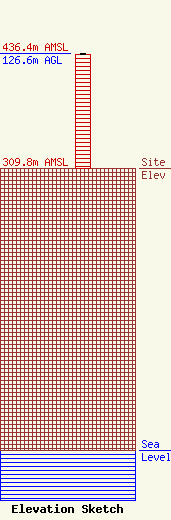
Site Elevation: 309.8 meters (1016 ft) |
| Height of Structure: 125.7 meters (412 feet) |
| Overall Height Above Ground: 126.6 meters (415 feet) |
| Overall Height Above Mean Sea Level: 436.4 meters (1432 feet) |
| Owner Info | TVT I, LLC
495 Tennessee Street, Suite # 152
Memphis, TN 38103
(901) 277-4083
royal@towerventures.com |
| Contact Info | TVT I, LLC
495 Tennessee Street, Suite # 152
Memphis, TN 38103
Craig Royal
(901) 277-4083
royal@towerventures.com |
