
FCCInfo.com
A Service of Cavell, Mertz & Associates, Inc.
(855) FCC-INFO
|
|
|
|
|
||||||||||||||||
|
|
K269FB Channel: 269D 101.7 MHz San Francisco, California Service: FX - A translator or application for a translator. Facility ID: 147348 Fac. Service: FX Programming Delivery Method: Unspecified Status: License Application Accepted: 01/17/2018 Application Granted: 02/06/2018 File Number: BLFT-20180117ABH License Expires: 00/00/0000 Prefix Type: This is a license for a translator Application Type: License To Cover FCC Website Links: LMS Facility Details This Application CDBS Application Other K269FB Applications Other K269FB Applications in CDBS Including Superseded Applications Mailing Address Correspondence for K269FB Correspondence related to application BLFT-20180117ABH Service Contour - Open Street Map or USGS Map (60 dBu) Service Contour - KML / Google Earth (60 dBu) Class: D, A Noncommercial educational operating with no more than 10W Site Location: 37-47-35.7 N 122-24-50.9 W (NAD 83) Site Location: 37-47-36.0 N 122-24-47.0 W (Converted to NAD 27) Effective Radiated Power: 0.24 kW Transmitter Output Power: 0.095 kW Antenna Center HAAT: 0 m Antenna Center AMSL: 194 m (636 ft.) Antenna Center HAG: 89 m (292 ft.) Site Elevation: 105 m. (344 ft.) Height Overall*: 109 m (358 ft.) (* As Filed In This Application, may differ from ASR Data, Below.) Directional Antenna Antenna Make/Model: None Antenna ID: 127074 Polarization:
| ||||||||||||||||||
| Antenna Data for Antenna Id: 127074 K269FB FX File: BLFT-20180117ABH None - Service: FX Pattern and Field Values Include a 242° Clockwise Rotation | 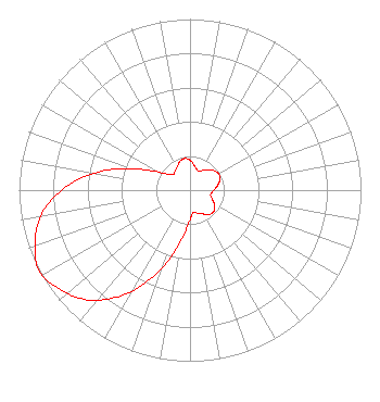 | ||||||||||||||||||
| Azimuth | Ratio | Azimuth | Ratio | Azimuth | Ratio | Azimuth | Ratio | ||||||||||||
| 2 | 0.171 | 12 | 0.140 | 22 | 0.123 | 32 | 0.135 | ||||||||||||
| 42 | 0.160 | 52 | 0.182 | 62 | 0.193 | 72 | 0.182 | ||||||||||||
| 82 | 0.160 | 92 | 0.135 | 102 | 0.123 | 112 | 0.140 | ||||||||||||
| 122 | 0.171 | 132 | 0.187 | 142 | 0.181 | 152 | 0.157 | ||||||||||||
| 162 | 0.142 | 172 | 0.134 | 182 | 0.190 | 192 | 0.329 | ||||||||||||
| 202 | 0.528 | 212 | 0.718 | 222 | 0.866 | 232 | 0.952 | ||||||||||||
| 242 | 1.000 | 252 | 0.952 | 262 | 0.866 | 272 | 0.718 | ||||||||||||
| 282 | 0.528 | 292 | 0.329 | 302 | 0.190 | 312 | 0.134 | ||||||||||||
| 322 | 0.142 | 332 | 0.157 | 342 | 0.181 | 352 | 0.187 | ||||||||||||
Structure Registration Number 1023253 Structure Type: BTWR Registered To: EIP Holdings II, LLC Structure Address: 1250 Jones St San Francisco, CA County Name: San Francisco County ASR Issued: 11/30/2023 Date Built: 01/01/1997 Site Elevation: 105.3 m (345 ft.) Structure Height: 71.3 m (234 ft.) Height Overall: 109.2 m (358 ft.) Overall Height AMSL: 214.5 m (704 ft.) FAA Determination: 05/08/1997 FAA Study #: 97-AWP-1115-OE FAA Circular #: 70/7460-1J Paint & Light FAA Chapters: 3, 4, 5, 13 Removed expiration date from determination. Scenario 1./jjs/case#635066 37-47-36.0 N 122-24-51.0 W (NAD 83) 37-47-36.3 N 122-24-47.1 W (Converted to NAD 27) |
680 Barclay Boulevard Lincolnshire, IL 60069 Phone: 877-291-0123 | Date: 01/17/2018 Application Certifier IMMACULATE HEART MEDIA, INC. 1496 Bellevue, Suite 202 Green Bay, WI 54311 Applicant ROBERT A. KAY, JR. 3256 Penryn Road Suite 100 Loomis, CA 95650-8052 ENGINEER MARK B. DENBO Smithwick & Belendiuk, P.c. 5028 Wisconsin Ave., N.w. Suite 301 Washington, DC 20016 | |||||||||||||||||