
FCCInfo.com
A Service of Cavell, Mertz & Associates, Inc.
(855) FCC-INFO
|
|
KNZR-FM from 02/06/2001 KNZR-FM from 11/07/1996 KNZR-FM from 12/01/1994 KNZR-FM from 02/12/1988 KNZR-FM from 04/14/1983 |
|  |
|
|||||||||||||||
|
|
KNZR-FM Channel: 249A 97.7 MHz Shafter, California Service: FM - A full-service FM station or application. Facility ID: 8109 Fac. Service: FM Status: License 73.215 Station Application Accepted: 04/20/2001 Application Granted: 07/30/2001 File Number: BLH-20010420AAX License Expires: 00/00/0000 Prefix Type: This is a license for a commercial FM station Application Type: License To Cover FCC Website Links: LMS Facility Details This Application CDBS Application Other KNZR-FM Applications Other KNZR-FM Applications in CDBS Including Superseded Applications Mailing Address Correspondence for KNZR-FM Correspondence related to application BLH-20010420AAX Service Contour - Open Street Map or USGS Map (60 dBu) Service Contour - KML / Google Earth (60 dBu) Public Inspection Files History Cards for KNZR-FM Facility Type: FM STATION Class: A, A Zone I; I-A; or II station; with 0.1kW-6kW ERP and a class contour distance <=28km Site Location: 35-27-32.8 N 119-01-16.4 W (NAD 83) Site Location: 35-27-33.0 N 119-01-13.0 W (Converted to NAD 27) Effective Radiated Power: 4.1 kW Transmitter Output Power: 4.7 kW Antenna Center HAAT: 121 m (397 ft.) Antenna Center AMSL: 324 m (1063 ft.) Antenna Center HAG: 56 m (184 ft.) Site Elevation: 268 m. (879 ft.) Height Overall*: 77 m (253 ft.) (* As Filed In This Application, may differ from ASR Data, Below.) Directional Antenna Antenna Make/Model: Electronics Research Inc. LP-2E-DA-HW Antenna ID: 39686 Polarization: | ||||||||||||||||||
| Antenna Data for Antenna Id: 39686 KNZR-FM FM File: BLH-20010420AAX Electronics Research Inc. - LP-2E-DA-HW Service: FM | 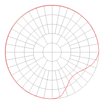 | ||||||||||||||||||
| Azimuth | Ratio | Azimuth | Ratio | Azimuth | Ratio | Azimuth | Ratio | ||||||||||||
| 0 | 1.000 | 10 | 1.000 | 20 | 1.000 | 30 | 1.000 | ||||||||||||
| 40 | 1.000 | 50 | 1.000 | 60 | 1.000 | 70 | 1.000 | ||||||||||||
| 80 | 1.000 | 90 | 1.000 | 100 | 0.951 | 110 | 0.865 | ||||||||||||
| 120 | 0.765 | 130 | 0.700 | 140 | 0.681 | 150 | 0.730 | ||||||||||||
| 160 | 0.845 | 170 | 0.966 | 180 | 1.000 | 190 | 1.000 | ||||||||||||
| 200 | 1.000 | 210 | 1.000 | 220 | 1.000 | 230 | 1.000 | ||||||||||||
| 240 | 1.000 | 250 | 1.000 | 260 | 1.000 | 270 | 1.000 | ||||||||||||
| 280 | 1.000 | 290 | 1.000 | 300 | 1.000 | 310 | 1.000 | ||||||||||||
| 320 | 1.000 | 330 | 1.000 | 340 | 1.000 | 350 | 1.000 | ||||||||||||
Structure Registration Number 1016015 Structure Type: TOWER Registered To: VB-S1 Assets, LLC Structure Address: 4.9 Km N Oildale, CA County Name: Kern County ASR Issued: 07/21/2020 Date Built: 01/01/1988 Site Elevation: 267.6 m (878 ft.) Structure Height: 76.2 m (250 ft.) Height Overall: 77 m (253 ft.) Overall Height AMSL: 344.6 m (1131 ft.) FAA Determination: 04/03/1989 FAA Study #: 89-AWP-1199-OE FAA Circular #: 70/7460-1G Paint & Light FAA Chapters: 3, 4, 5, 9 35-27-33.0 N 119-01-16.0 W (NAD 83) 35-27-33.2 N 119-01-12.6 W (Converted to NAD 27) |
1211 Sw 5th Avenue Suite 750 Portland, OR 97204 Phone: 503-517-6200 Limited Liability Company | Date: 04/20/2001 Application Certifier BUCKLEY BROADCASTING CORPORATION OF CALIFORNIA 166 West Putnam Avenue Greenwich, CT 06830 Applicant ROBERT F. TURNER 7200 Mesa Verde Way Bakersfield, CA 93309 INSTALLING ENGINEER COLETTE M. CAPRETZ, ESQ. Shaw Pittman | |||||||||||||||||
| |||||||||||||||||||