
FCCInfo.com
A Service of Cavell, Mertz & Associates, Inc.
(855) FCC-INFO
|
|
|
|
|
||||||||||||||||
|
|
K219DK Channel: 219D 91.7 MHz Victorville, California Service: FX - A translator or application for a translator. Facility ID: 85689 Fac. Service: FX Programming Delivery Method: Unspecified Status: License Application Accepted: 07/31/1998 Application Granted: 10/29/1998 File Number: BLFT-19980731TE License Expires: 00/00/0000 Prefix Type: This is a license for a translator Application Type: License To Cover FCC Website Links: LMS Facility Details This Application CDBS Application Other K219DK Applications Other K219DK Applications in CDBS Including Superseded Applications Mailing Address Correspondence for K219DK Correspondence related to application BLFT-19980731TE Service Contour - Open Street Map or USGS Map (60 dBu) Service Contour - KML / Google Earth (60 dBu) Class: D, A Noncommercial educational operating with no more than 10W Site Location: 34-36-44.0 N 117-17-30.2 W (NAD 83) Site Location: 34-36-44.0 N 117-17-27.0 W (Converted to NAD 27) Effective Radiated Power: 0 kW Horiz. ; 0.01 kW Vert. Antenna Center HAAT: 430 m Horiz.; 0 m Vert. Antenna Center AMSL: 0 m Horiz.; 1333 m Vert. Antenna Center HAG: 0 m Horiz.; 4 m Vert. Calculated Site Elevation: m. Height Overall*: 30 m (98 ft.) (* As Filed In This Application, may differ from ASR Data, Below.) Directional Antenna Antenna Make/Model: None Antenna ID: 16162 Polarization:
| ||||||||||||||||||
| Antenna Data for Antenna Id: 16162 K219DK FX File: BLFT-19980731TE None - Service: FX Pattern and Field Values Include a 180° Clockwise Rotation | 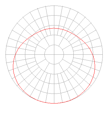 | ||||||||||||||||||
| Azimuth | Ratio | Azimuth | Ratio | Azimuth | Ratio | Azimuth | Ratio | ||||||||||||
| 0 | 0.534 | 10 | 0.535 | 20 | 0.540 | 30 | 0.549 | ||||||||||||
| 40 | 0.566 | 50 | 0.592 | 60 | 0.630 | 70 | 0.679 | ||||||||||||
| 80 | 0.735 | 90 | 0.792 | 100 | 0.845 | 110 | 0.892 | ||||||||||||
| 120 | 0.929 | 130 | 0.956 | 140 | 0.975 | 150 | 0.987 | ||||||||||||
| 160 | 0.995 | 170 | 0.999 | 180 | 1.000 | 190 | 0.999 | ||||||||||||
| 200 | 0.995 | 210 | 0.987 | 220 | 0.975 | 230 | 0.956 | ||||||||||||
| 240 | 0.929 | 250 | 0.892 | 260 | 0.845 | 270 | 0.792 | ||||||||||||
| 280 | 0.735 | 290 | 0.679 | 300 | 0.630 | 310 | 0.592 | ||||||||||||
| 320 | 0.566 | 330 | 0.549 | 340 | 0.540 | 350 | 0.535 | ||||||||||||
Structure Registration Number 1045372 [ASR Heights Differ from K219DK Application] Structure Type: LTOWER Registered To: EDUCATIONAL MEDIA FOUNDATION Structure Address: Quartzite Mountain, 3 Mi E Of Orogrande Victorville, CA County Name: San Bernardino County ASR Issued: 10/20/2020 Date Built: 10/20/2020 Site Elevation: 1329 m (4360 ft.) Structure Height: 30 m (98 ft.) Height Overall: 30 m (98 ft.) Overall Height AMSL: 1359 m (4459 ft.) FAA Determination: 09/28/2020 FAA Study #: 2020-AWP-10751-OE Paint & Light FAA Chapters: NONE PRIOR STUDY 1990-AWP-366-OE 34-36-44.1 N 117-17-32.7 W (NAD 83) 34-36-44.1 N 117-17-29.5 W (Converted to NAD 27) |
2310 Ponderosa Drive Suite 28 Camarillo, CA 93010-4747 Phone: 805-482-4797 | Date: 07/31/1998 Application Certifier THE ASSOC. FOR COMMUNITY EDUC, INC The Association For Community Education, Inc. 2310 Ponderosa Drive Suite 28 Camarillo, CA 93010 Applicant | |||||||||||||||||