
FCCInfo.com
A Service of Cavell, Mertz & Associates, Inc.
(855) FCC-INFO
|
|
|
|  |
|
||||||||||||||||||||||||
|
|
WDOD-FM Channel: 243C0 96.5 MHz Chattanooga, Tennessee Service: FM - A full-service FM station or application. Facility ID: 71351 Fac. Service: FM Status: License Application Accepted: 02/22/2001 Application Granted: 10/23/2002 File Number: BLH-20010222AAI License Expires: 00/00/0000 Prefix Type: This is a license for a commercial FM station Application Type: Amendment FCC Website Links: LMS Facility Details This Application CDBS Application Other WDOD-FM Applications Other WDOD-FM Applications in CDBS Including Superseded Applications Mailing Address Correspondence for WDOD-FM Correspondence related to application BLH-20010222AAI Service Contour - Open Street Map or USGS Map (60 dBu) Service Contour - KML / Google Earth (60 dBu) Public Inspection Files History Cards for WDOD-FM Facility Type: FM STATION Class: C0, C0 Site Location: 35-09-41.3 N 85-19-04.9 W (NAD 83) Site Location: 35-09-41.0 N 85-19-05.0 W (Converted to NAD 27) Effective Radiated Power: 100 kW Horiz. ; 88 kW Vert. Transmitter Output Power: 19.07 kW Antenna Center HAAT: 336 m (1102 ft.) Antenna Center AMSL: 720 m (2362 ft.) Antenna Center HAG: 84 m (276 ft.) Site Elevation: 635.8 m. (2086 ft.) Height Overall*: 92.4 m (303 ft.) (* As Filed In This Application, may differ from ASR Data, Below.) Directional Antenna Antenna Make/Model: Electronics Research Inc. MP-6E-DA Antenna ID: 38944 Polarization: | |||||||||||||||||||||||||||
| Antenna Data for Antenna Id: 38944 WDOD-FM FM File: BLH-20010222AAI Electronics Research Inc. - MP-6E-DA Service: FM | 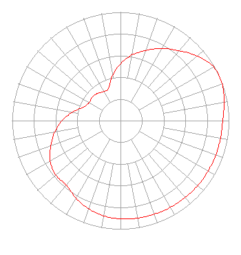 | |||||||||||||||||||||||||||
| Azimuth | Ratio | Azimuth | Ratio | Azimuth | Ratio | Azimuth | Ratio | |||||||||||||||||||||
| 0 | 0.523 | 10 | 0.613 | 20 | 0.687 | 30 | 0.767 | |||||||||||||||||||||
| 40 | 0.841 | 50 | 0.925 | 60 | 0.991 | 70 | 0.996 | |||||||||||||||||||||
| 80 | 0.971 | 90 | 0.943 | 100 | 0.936 | 110 | 0.935 | |||||||||||||||||||||
| 120 | 0.932 | 130 | 0.930 | 140 | 0.926 | 150 | 0.922 | |||||||||||||||||||||
| 160 | 0.917 | 170 | 0.912 | 180 | 0.906 | 190 | 0.890 | |||||||||||||||||||||
| 200 | 0.862 | 210 | 0.824 | 220 | 0.777 | 230 | 0.780 | |||||||||||||||||||||
| 240 | 0.749 | 250 | 0.683 | 260 | 0.616 | 270 | 0.540 | |||||||||||||||||||||
| 280 | 0.447 | 290 | 0.364 | 300 | 0.334 | 310 | 0.339 | |||||||||||||||||||||
| 320 | 0.328 | 330 | 0.308 | 340 | 0.318 | 350 | 0.420 | |||||||||||||||||||||
Structure Registration Number 1051868 Structure Type: GTOWER Registered To: WDOD OF CHATTANOOGA, INC. D/B/A WDOD-FM Structure Address: 2603 Anderson Pike Signal Mountain, TN County Name: Hamilton County ASR Issued: 07/27/2015 Date Built: 01/23/1976 Site Elevation: 635.8 m (2086 ft.) Structure Height: 91 m (299 ft.) Height Overall: 92.4 m (303 ft.) Overall Height AMSL: 728.2 m (2389 ft.) FAA Determination: 08/10/1972 FAA Study #: 72-SO-1348-OE FAA Circular #: 70/7460-1 Paint & Light FAA Chapters: 1, 3, 12, 21 RED LIGHTS/PAINT 35-09-41.4 N 85-19-05.0 W (NAD 83) 35-09-41.1 N 85-19-05.1 W (Converted to NAD 27) |
One Television Place Charlotte, NC 28205 Phone: 704-632-7227 Corporation | Date: 02/22/2001 Application Certifier WDOD OF CHATTANOOGA, INC. C/o Brooks, Pierce, Et. Al Po Box 1800 Raleigh, NC 27602 Applicant ROBERT G. MALLERY 6444 Bock Road Oxon Hill, MD 20745-3001 TECHNICAL CONSULTANT COE W. RAMSEY Brooks, Pierce, Et. Al. | ||||||||||||||||||||||||||
|
| |||||||||||||||||||||||||||