
FCCInfo.com
A Service of Cavell, Mertz & Associates, Inc.
(855) FCC-INFO
|
|
WLFV from 09/13/2005 WLFV from 03/22/2004 WLFV from 02/07/1990 WLFV from 12/15/1984 WLFV from 06/05/1980 |
|
|
||||||||||||||||
|
|
WLFV Channel: 255B1 98.9 MHz Midlothian, Virginia Service: FM - A full-service FM station or application. Facility ID: 54872 Fac. Service: FM Status: License 73.215 Station Application Accepted: 12/07/2016 Application Granted: 03/30/2017 File Number: BMLED-20161207AAW License Expires: 00/00/0000 Prefix Type: This is a modification of license for a noncommercial educational FM station Application Type: Minor Modification FCC Website Links: LMS Facility Details This Application CDBS Application Other WLFV Applications Other WLFV Applications in CDBS Including Superseded Applications Mailing Address Correspondence for WLFV Correspondence related to application BMLED-20161207AAW Service Contour - Open Street Map or USGS Map (57 dBu) Service Contour - KML / Google Earth (57 dBu) Public Inspection Files History Cards for WLFV Facility Type: NON-COMMERCIAL EDUC. FM Class: B1, A Zone I or I-A station; with 6kW-25kW ERP and a class contour distance 28km-39km Site Location: 37-36-52.5 N 77-30-55.0 W (NAD 83) Site Location: 37-36-52.0 N 77-30-56.1 W (Converted to NAD 27) Effective Radiated Power: 4.8 kW Transmitter Output Power: 8.2 kW Antenna Center HAAT: 227.4 m (746 ft.) Antenna Center AMSL: 285 m (935 ft.) Antenna Center HAG: 207.3 m (680 ft.) Calculated Site Elevation: 77.7 m. (255 ft.) Height Overall*: 228.3 m (749 ft.) (* As Filed In This Application, may differ from ASR Data, Below.) Directional Antenna Antenna Make/Model: Jampro JAHD-1/3(3) DA Antenna ID: 68890 Polarization: | ||||||||||||||||||
| Antenna Data for Antenna Id: 68890 WLFV FM File: BMLED-20161207AAW Jampro - JAHD-1/3(3) DA Service: FM | 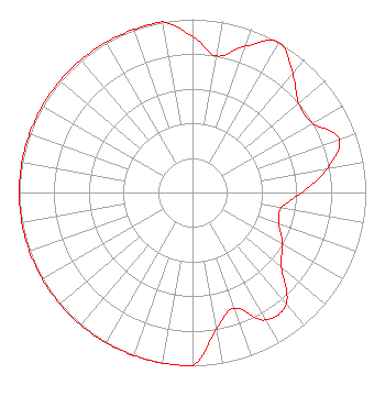 | ||||||||||||||||||
| Azimuth | Ratio | Azimuth | Ratio | Azimuth | Ratio | Azimuth | Ratio | ||||||||||||
| 0 | 0.900 | 10 | 0.800 | 20 | 0.900 | 30 | 1.000 | ||||||||||||
| 40 | 0.900 | 50 | 0.800 | 60 | 0.800 | 70 | 0.900 | ||||||||||||
| 80 | 0.790 | 90 | 0.630 | 100 | 0.520 | 110 | 0.530 | ||||||||||||
| 120 | 0.600 | 130 | 0.670 | 140 | 0.840 | 150 | 0.850 | ||||||||||||
| 160 | 0.710 | 170 | 0.800 | 180 | 1.000 | 190 | 1.000 | ||||||||||||
| 200 | 1.000 | 210 | 1.000 | 220 | 1.000 | 230 | 1.000 | ||||||||||||
| 240 | 1.000 | 250 | 1.000 | 260 | 1.000 | 270 | 1.000 | ||||||||||||
| 280 | 1.000 | 290 | 1.000 | 300 | 1.000 | 310 | 1.000 | ||||||||||||
| 320 | 1.000 | 330 | 1.000 | 340 | 1.000 | 350 | 1.000 | ||||||||||||
Structure Registration Number 1026628 [ASR Heights Differ from WLFV Application] Structure Type: GTOWER Registered To: Vertical Bridge CC FM, LLC Structure Address: 3245 Basie Road / Us-va-5026 Richmond, VA County Name: Henrico County ASR Issued: 11/08/2018 Date Built: 07/01/1992 Site Elevation: 78.3 m (257 ft.) Structure Height: 212.2 m (696 ft.) Height Overall: 227.1 m (745 ft.) Overall Height AMSL: 305.4 m (1002 ft.) FAA Determination: 09/27/2017 FAA Study #: 2017-AEA-9810-OE Paint & Light FAA Chapters: A1, B, D, H, 3, 6, 15, 21, 23 Continue As Is OM&L = A HIGH-DUAL SYSTEM 37-36-52.0 N 77-30-55.2 W (NAD 83) 37-36-51.5 N 77-30-56.3 W (Converted to NAD 27) |
5700 West Oaks Blvd. Rocklin, CA 95765 Phone: 916-251-1600 Not-for-Profit | Date: 12/07/2016 Application Certifier EDUCATIONAL MEDIA FOUNDATION 5700 West Oaks Blvd. Rocklin, CA 95765 Applicant SAM WALLINGTON 5700 West Oaks Blvd. Rocklin, CA 95765 VP OF ENGINEERING MARY O'CONNOR Wilkinson Barker Knauer, Llp | |||||||||||||||||