
FCCInfo.com
A Service of Cavell, Mertz & Associates, Inc.
(855) FCC-INFO
|
|
|
|
|
||||||||||||||||
|
|
W284BQ Channel: 284D 104.7 MHz Detroit, Michigan Service: FX - A translator or application for a translator. Facility ID: 143173 Fac. Service: FX Programming Delivery Method: Unspecified Status: License Application Accepted: 07/27/2017 Application Granted: 08/07/2017 File Number: BLFT-20170727ABT License Expires: 00/00/0000 Prefix Type: This is a license for a translator Application Type: License To Cover FCC Website Links: LMS Facility Details This Application CDBS Application Other W284BQ Applications Other W284BQ Applications in CDBS Including Superseded Applications Mailing Address Correspondence for W284BQ Correspondence related to application BLFT-20170727ABT Service Contour - Open Street Map or USGS Map (60 dBu) Service Contour - KML / Google Earth (60 dBu) Class: D, A Noncommercial educational operating with no more than 10W Site Location: 42-36-16.3 N 82-54-42.7 W (NAD 83) Site Location: 42-36-16.2 N 82-54-43.0 W (Converted to NAD 27) Effective Radiated Power: 0.25 kW Transmitter Output Power: 0.55 kW Antenna Center HAAT: 0 m Antenna Center AMSL: 236 m (774 ft.) Antenna Center HAG: 56 m (184 ft.) Site Elevation: 180 m. (591 ft.) Height Overall*: 61 m (200 ft.) (* As Filed In This Application, may differ from ASR Data, Below.) Directional Antenna Antenna Make/Model: None Antenna ID: 126459 Polarization:
| ||||||||||||||||||
| Antenna Data for Antenna Id: 126459 W284BQ FX File: BLFT-20170727ABT None - Service: FX | 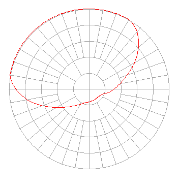 | ||||||||||||||||||
| Azimuth | Ratio | Azimuth | Ratio | Azimuth | Ratio | Azimuth | Ratio | ||||||||||||
| 0 | 1.000 | 10 | 1.000 | 20 | 1.000 | 30 | 1.000 | ||||||||||||
| 40 | 0.931 | 50 | 0.804 | 60 | 0.654 | 70 | 0.508 | ||||||||||||
| 80 | 0.398 | 90 | 0.315 | 100 | 0.251 | 110 | 0.188 | ||||||||||||
| 120 | 0.164 | 130 | 0.152 | 140 | 0.150 | 150 | 0.150 | ||||||||||||
| 160 | 0.155 | 170 | 0.155 | 180 | 0.163 | 190 | 0.171 | ||||||||||||
| 200 | 0.188 | 210 | 0.223 | 220 | 0.272 | 230 | 0.351 | ||||||||||||
| 240 | 0.464 | 250 | 0.616 | 260 | 0.782 | 270 | 0.913 | ||||||||||||
| 280 | 1.000 | 290 | 1.000 | 300 | 1.000 | 310 | 1.000 | ||||||||||||
| 320 | 1.000 | 330 | 1.000 | 340 | 1.000 | 350 | 1.000 | ||||||||||||
Structure Registration Number 1244020 Structure Type: 4TA1 Registered To: Relevant Radio, Inc. Structure Address: 0.37 Mi E-se Of Intersection Of Cass Ave & Heydenreich Street Mount Clemens, MI County Name: Macomb County ASR Issued: 03/01/2023 Date Built: 07/11/2007 Site Elevation: 180.4 m (592 ft.) Structure Height: 61 m (200 ft.) Height Overall: 61 m (200 ft.) Overall Height AMSL: 241.4 m (792 ft.) FAA Determination: 06/24/2004 FAA Study #: 2004-AGL-3165-OE Paint & Light FAA Chapters: NONE Removed expiration date from determination. Scenario 1./jjs/case#635066 42-36-16.3 N 82-54-42.7 W (NAD 83) 42-36-16.2 N 82-54-43.0 W (Converted to NAD 27) |
680 Barclay Boulevard Lincolnshire, IL 60069 Phone: 877-291-0123 Not-for-Profit | Date: 07/27/2017 Application Certifier FAMILY LIFE BROADCASTING SYSTEM 7355 North Oracle Road Tucson, AZ 85704 Applicant MICHAEL K BRINKS 7355 N. Oracle Road Tucson, AZ 85704 DIRECTOR OF SIGNAL DEVELOPMENT AND FCC COMPLIANCE JOSEPH C. CHAUTIN, III Hardy, Carey, Chautin & Balkin, Llp 1080 West Causeway Approach Mandeville, LA 70471 | |||||||||||||||||