
FCCInfo.com
A Service of Cavell, Mertz & Associates, Inc.
(855) FCC-INFO
|
|
K203EU from 12/12/1996 |
|
|
||||||||||||||||
|
|
K203EU Channel: 203D 88.5 MHz Hutchinson, Kansas Service: FX - A translator or application for a translator. Facility ID: 77282 Fac. Service: FX Programming Delivery Method: Unspecified Status: License Application Accepted: 12/10/2015 Application Granted: 12/18/2015 File Number: BLFT-20151210ACB License Expires: 00/00/0000 Prefix Type: This is a license for a translator Application Type: License To Cover FCC Website Links: LMS Facility Details This Application CDBS Application Other K203EU Applications Other K203EU Applications in CDBS Including Superseded Applications Mailing Address Correspondence for K203EU Correspondence related to application BLFT-20151210ACB Service Contour - Open Street Map or USGS Map (60 dBu) Service Contour - KML / Google Earth (60 dBu) Class: D, A Noncommercial educational operating with no more than 10W Site Location: 38-02-57.0 N 98-00-45.2 W (NAD 83) Site Location: 38-02-57.0 N 98-00-44.0 W (Converted to NAD 27) Effective Radiated Power: 0 kW Horiz. ; 0.075 kW Vert. Transmitter Output Power: 0.104 kW Antenna Center HAAT: 0 m Antenna Center AMSL: 0 m Horiz.; 588 m Vert. Antenna Center HAG: 0 m Horiz.; 104 m Vert. Site Elevation: 484 m. (1588 ft.) Height Overall*: 152 m (499 ft.) (* As Filed In This Application, may differ from ASR Data, Below.) Directional Antenna Antenna Make/Model: None Antenna ID: 31326 Polarization:
| ||||||||||||||||||
| Antenna Data for Antenna Id: 31326 K203EU FX File: BLFT-20151210ACB None - Service: FX Pattern and Field Values Include a 90° Clockwise Rotation | 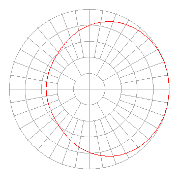 | ||||||||||||||||||
| Azimuth | Ratio | Azimuth | Ratio | Azimuth | Ratio | Azimuth | Ratio | ||||||||||||
| 0 | 0.792 | 10 | 0.845 | 20 | 0.892 | 30 | 0.929 | ||||||||||||
| 40 | 0.956 | 50 | 0.975 | 60 | 0.987 | 70 | 0.995 | ||||||||||||
| 80 | 0.999 | 90 | 1.000 | 100 | 0.999 | 110 | 0.995 | ||||||||||||
| 120 | 0.987 | 130 | 0.975 | 140 | 0.956 | 150 | 0.929 | ||||||||||||
| 160 | 0.892 | 170 | 0.845 | 180 | 0.792 | 190 | 0.735 | ||||||||||||
| 200 | 0.679 | 210 | 0.630 | 220 | 0.592 | 230 | 0.566 | ||||||||||||
| 240 | 0.549 | 250 | 0.540 | 260 | 0.535 | 270 | 0.534 | ||||||||||||
| 280 | 0.535 | 290 | 0.540 | 300 | 0.549 | 310 | 0.566 | ||||||||||||
| 320 | 0.592 | 330 | 0.630 | 340 | 0.679 | 350 | 0.735 | ||||||||||||
Structure Registration Number 1252762 Structure Type: TOWER Registered To: K2 Towers II, LLC Structure Address: 5 Miles West Of City Hutchinson, KS County Name: Reno County ASR Issued: 12/24/2019 Date Built: 02/06/2007 Site Elevation: 483.7 m (1587 ft.) Structure Height: 151.2 m (496 ft.) Height Overall: 152.1 m (499 ft.) Overall Height AMSL: 635.8 m (2086 ft.) FAA Determination: 03/10/2006 FAA Study #: 2006-ACE-228-OE FAA Circular #: 70/7460-1K Paint & Light FAA Chapters: 4, 8, 12 Removed expiration date from determination. Scenario 1./jjs/case#635066 38-02-57.2 N 98-00-45.2 W (NAD 83) 38-02-57.2 N 98-00-44.0 W (Converted to NAD 27) |
P.o. Box 391 4002 N. 3300 E. Twin Falls, ID 83303 Phone: 208-733-3133 | Date: 12/10/2015 Application Certifier CALVARY CHAPEL OF TWIN FALLS, INC. Po Box 391 Twin Falls, ID 83303 Applicant LOIS MILLS Po Box 391 Twin Falls, ID 83303 APPLICATION TECHNICIAN CARY TEPPER Tepper Law Firm, Llc 4900 Auburn Avenue, Suite 100 Bethesda, MD 20814-2632 | |||||||||||||||||