
FCCInfo.com
A Service of Cavell, Mertz & Associates, Inc.
(855) FCC-INFO
|
|
|
|
|
||||||||||||||||
|
|
K237CB Channel: 237D 95.3 MHz Eagle, Etc., Colorado Service: FX - A translator or application for a translator. Facility ID: 44013 Fac. Service: FX Programming Delivery Method: Unspecified Status: License Application Accepted: 11/14/2003 Application Granted: 01/26/2004 File Number: BLFT-20031114AAW License Expires: 00/00/0000 Prefix Type: This is a license for a translator Application Type: License To Cover FCC Website Links: LMS Facility Details This Application CDBS Application Other K237CB Applications Other K237CB Applications in CDBS Including Superseded Applications Mailing Address Correspondence for K237CB Correspondence related to application BLFT-20031114AAW Service Contour - Open Street Map or USGS Map (60 dBu) Service Contour - KML / Google Earth (60 dBu) Class: D, A Noncommercial educational operating with no more than 10W Site Location: 39-38-39.0 N 106-51-38.1 W (NAD 83) Site Location: 39-38-39.1 N 106-51-36.0 W (Converted to NAD 27) Effective Radiated Power: 0.054 kW Horiz. ; 0 kW Vert. Transmitter Output Power: 0.011 kW Antenna Center HAAT: -219.1 m Horiz.; 0 m Vert. Antenna Center AMSL: 2149 m Horiz.; 0 m Vert. Antenna Center HAG: 14 m Horiz.; 0 m Vert. Site Elevation: 2135 m. (7005 ft.) Height Overall*: 22 m (72 ft.) (* As Filed In This Application, may differ from ASR Data, Below.) Directional Antenna Antenna Make/Model: None Antenna ID: 44995 Polarization:
| ||||||||||||||||||
| Antenna Data for Antenna Id: 44995 K237CB FX File: BLFT-20031114AAW None - Service: FX | 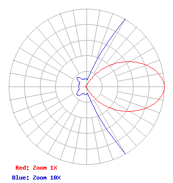 | ||||||||||||||||||
| Azimuth | Ratio | Azimuth | Ratio | Azimuth | Ratio | Azimuth | Ratio | ||||||||||||
| 0 | 0.010 | 10 | 0.010 | 20 | 0.030 | 30 | 0.102 | ||||||||||||
| 40 | 0.260 | 50 | 0.452 | 60 | 0.637 | 70 | 0.812 | ||||||||||||
| 80 | 0.940 | 90 | 1.000 | 100 | 0.944 | 110 | 0.812 | ||||||||||||
| 120 | 0.637 | 130 | 0.452 | 140 | 0.269 | 150 | 0.102 | ||||||||||||
| 160 | 0.030 | 170 | 0.010 | 180 | 0.010 | 190 | 0.010 | ||||||||||||
| 200 | 0.010 | 210 | 0.011 | 220 | 0.015 | 230 | 0.016 | ||||||||||||
| 240 | 0.013 | 250 | 0.010 | 260 | 0.010 | 270 | 0.010 | ||||||||||||
| 280 | 0.010 | 290 | 0.010 | 300 | 0.010 | 310 | 0.016 | ||||||||||||
| 320 | 0.015 | 330 | 0.011 | 340 | 0.010 | 350 | 0.010 | ||||||||||||
Structure Registration Number 1236392 [ASR Heights Differ from K237CB Application] Structure Type: TOWER Registered To: Salisbury Broadcasting Colorado, LLC Structure Address: Eagle County Regional Airport Eagle, CO County Name: Eagle County ASR Issued: 10/25/2002 Date Built: 10/21/2002 Site Elevation: 2134.5 m (7003 ft.) Structure Height: 21.3 m (70 ft.) Height Overall: 21.6 m (71 ft.) Overall Height AMSL: 2156.1 m (7074 ft.) FAA Determination: 09/17/2002 FAA Study #: 2001-ANM-2830-OE FAA Circular #: 70/7460-1K Paint & Light FAA Chapters: 4, 5, 12 Removed expiration date from determination. Scenario 1./jjs/case#635066 39-38-39.9 N 106-51-38.1 W (NAD 83) 39-38-40.0 N 106-51-36.0 W (Converted to NAD 27) |
5670 Greenwood Plaza Blvd. Suite 506 Greenwood Village, CO 80111 Phone: 720-726-7770 | Date: 11/14/2003 Application Certifier SALISBURY BROADCASTING COLORADO, LLC 300 E. Lombard Street, Suite 620 Baltimore, MD 21202 Applicant ELLIOTT KLEIN Klein Broadcast Engineering 5529 East Sapphire Lane Paradise Valley, AZ 85253 CONSULTING ENGINEER JOHN NEELY, ESQ. Miller And Neely, P.c. Suite 704 6900 Wisconsin Ave. Bethesda, MD 20815 | |||||||||||||||||