
FCCInfo.com
A Service of Cavell, Mertz & Associates, Inc.
(855) FCC-INFO
|
|
|
|  |
|
|||||||||||||||
|
|
WIGH Channel: 204C2 88.7 MHz Jackson, Tennessee Service: FM - A full-service FM station or application. Facility ID: 25543 Fac. Service: FM Status: License Application Accepted: 06/03/2009 Application Granted: 08/05/2009 File Number: BLED-20090603ABA License Expires: 00/00/0000 Prefix Type: This is a license for a noncommercial educational FM station Application Type: License To Cover FCC Website Links: LMS Facility Details This Application CDBS Application Other WIGH Applications Other WIGH Applications in CDBS Including Superseded Applications Mailing Address Correspondence for WIGH Correspondence related to application BLED-20090603ABA Service Contour - Open Street Map or USGS Map (60 dBu) Service Contour - KML / Google Earth (60 dBu) Public Inspection Files Facility Type: NON-COMMERCIAL EDUC. FM Class: C2, A Zone II station; with 25kW-50kW ERP and a class contour distance 39km-52km Site Location: 35-43-19.2 N 88-36-07.2 W (NAD 83) Site Location: 35-43-19.0 N 88-36-07.0 W (Converted to NAD 27) Effective Radiated Power: 14 kW Transmitter Output Power: 2.833 kW Antenna Center HAAT: 164 m (538 ft.) Antenna Center AMSL: 312 m (1024 ft.) Antenna Center HAG: 143 m (469 ft.) Calculated Site Elevation: 169 m. (554 ft.) Height Overall*: 152 m (499 ft.) (* As Filed In This Application, may differ from ASR Data, Below.) Directional Antenna Antenna Make/Model: Shivley 6810-6R-DA, six sections Antenna ID: 80872 Polarization: | ||||||||||||||||||
| Antenna Data for Antenna Id: 80872 WIGH FM File: BLED-20090603ABA Shivley - 6810-6R-DA, six sections Service: FM | 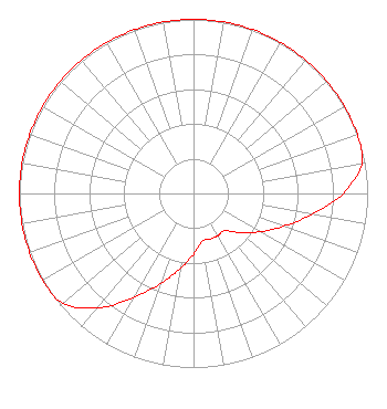 | ||||||||||||||||||
| Azimuth | Ratio | Azimuth | Ratio | Azimuth | Ratio | Azimuth | Ratio | ||||||||||||
| 0 | 1.000 | 10 | 1.000 | 20 | 1.000 | 30 | 1.000 | ||||||||||||
| 40 | 1.000 | 50 | 1.000 | 60 | 1.000 | 70 | 1.000 | ||||||||||||
| 80 | 0.980 | 90 | 0.860 | 100 | 0.690 | 110 | 0.550 | ||||||||||||
| 120 | 0.440 | 130 | 0.350 | 140 | 0.280 | 150 | 0.280 | ||||||||||||
| 160 | 0.280 | 170 | 0.280 | 180 | 0.350 | 190 | 0.440 | ||||||||||||
| 200 | 0.550 | 210 | 0.690 | 220 | 0.860 | 230 | 0.980 | ||||||||||||
| 240 | 1.000 | 250 | 1.000 | 260 | 1.000 | 270 | 1.000 | ||||||||||||
| 280 | 1.000 | 290 | 1.000 | 300 | 1.000 | 310 | 1.000 | ||||||||||||
| 320 | 1.000 | 330 | 1.000 | 340 | 1.000 | 350 | 1.000 | ||||||||||||
Structure Registration Number 1240161 Structure Type: TOWER Registered To: AMERICAN FAMILY ASSOCIATION Structure Address: Independence Loop, Lexington, Tn Lexington, TN County Name: Henderson County ASR Issued: 10/19/2009 Date Built: 11/03/2003 Site Elevation: 169.1 m (555 ft.) Structure Height: 151.7 m (498 ft.) Height Overall: 151.7 m (498 ft.) Overall Height AMSL: 320.8 m (1052 ft.) FAA Determination: 08/08/2003 FAA Study #: 2003-ASO-3233-OE FAA Circular #: 70/7460-1K Paint & Light FAA Chapters: 4, 6, 12 35-43-19.4 N 88-36-07.1 W (NAD 83) 35-43-19.2 N 88-36-06.9 W (Converted to NAD 27) |
Po Box 2440 Tupelo, MS 38801-2440 Phone: 662-844-8888 Not-for-Profit | Date: 06/03/2009 Application Certifier AMERICAN FAMILY ASSOCIATION P.o. Drawer 2440 Tupelo, MS 38801 Applicant JESSICA HUCKABY P.o. Drawer 2440 Tupelo, MS 38803 TECHNICAL CONSULTANT JESSICA HUCKABY American Family Association | |||||||||||||||||