
FCCInfo.com
A Service of Cavell, Mertz & Associates, Inc.
(855) FCC-INFO
|
|
K256CP from 04/15/2013 |
|
|
||||||||||||||||
|
|
K256CP Channel: 256D 99.1 MHz Bartlesville, Oklahoma Service: FX - A translator or application for a translator. Facility ID: 139222 Fac. Service: FX Programming Delivery Method: Unspecified Status: License Application Accepted: 05/12/2016 Application Granted: 05/27/2016 File Number: BLFT-20160512ABB License Expires: 00/00/0000 Prefix Type: This is a license for a translator Application Type: License To Cover FCC Website Links: LMS Facility Details This Application CDBS Application Other K256CP Applications Other K256CP Applications in CDBS Including Superseded Applications Mailing Address Correspondence for K256CP Correspondence related to application BLFT-20160512ABB Service Contour - Open Street Map or USGS Map (60 dBu) Service Contour - KML / Google Earth (60 dBu) Class: D, A Noncommercial educational operating with no more than 10W Site Location: 36-37-42.3 N 96-11-27.0 W (NAD 83) Site Location: 36-37-42.0 N 96-11-26.0 W (Converted to NAD 27) Effective Radiated Power: 0.25 kW Transmitter Output Power: 0.199 kW Antenna Center HAAT: 0 m Antenna Center AMSL: 430 m (1411 ft.) Antenna Center HAG: 150 m (492 ft.) Site Elevation: 280 m. (919 ft.) Height Overall*: 213 m (699 ft.) (* As Filed In This Application, may differ from ASR Data, Below.) Directional Antenna Antenna Make/Model: None Antenna ID: 123723 Polarization:
| ||||||||||||||||||
| Antenna Data for Antenna Id: 123723 K256CP FX File: BLFT-20160512ABB None - Service: FX | 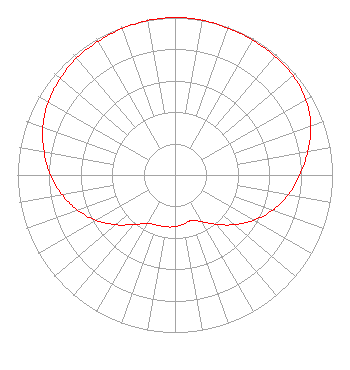 | ||||||||||||||||||
| Azimuth | Ratio | Azimuth | Ratio | Azimuth | Ratio | Azimuth | Ratio | ||||||||||||
| 0 | 1.000 | 10 | 0.998 | 20 | 0.993 | 30 | 0.988 | ||||||||||||
| 40 | 0.986 | 50 | 0.980 | 60 | 0.959 | 70 | 0.918 | ||||||||||||
| 80 | 0.856 | 90 | 0.792 | 100 | 0.729 | 110 | 0.658 | ||||||||||||
| 120 | 0.576 | 130 | 0.491 | 140 | 0.409 | 150 | 0.343 | ||||||||||||
| 160 | 0.307 | 170 | 0.316 | 180 | 0.328 | 190 | 0.334 | ||||||||||||
| 200 | 0.338 | 210 | 0.356 | 220 | 0.411 | 230 | 0.491 | ||||||||||||
| 240 | 0.576 | 250 | 0.656 | 260 | 0.728 | 270 | 0.792 | ||||||||||||
| 280 | 0.844 | 290 | 0.892 | 300 | 0.929 | 310 | 0.952 | ||||||||||||
| 320 | 0.970 | 330 | 0.979 | 340 | 0.988 | 350 | 0.996 | ||||||||||||
Structure Registration Number 1217183 Structure Type: GTOWER Registered To: KCD Towers, LLC Structure Address: South Side Of Dirt Road, Se Corner Of Section 23, 4.8 Km East Of Nelagoney Nelagoney, OK County Name: Osage County ASR Issued: 09/20/2017 Date Built: 11/15/2017 Site Elevation: 280.4 m (920 ft.) Structure Height: 212.5 m (697 ft.) Height Overall: 213.3 m (700 ft.) Overall Height AMSL: 493.7 m (1620 ft.) FAA Determination: 09/12/2017 FAA Study #: 2017-ASW-9873-OE FAA Circular #: 70/7460-1L Paint & Light FAA Chapters: 4, 8, 12 PRIOR STUDY 2000-ASW-1313-OE 36-37-42.3 N 96-11-27.0 W (NAD 83) 36-37-42.0 N 96-11-26.0 W (Converted to NAD 27) |
1200 Se Frank Phillips Blvd. Bartlesville, OK 74003 Phone: 918-336-1001 | Date: 05/12/2016 Application Certifier POTTER RADIO, LLC 1200 Se Frank Phillips Blvd. Bartlesville, OK 74003 Applicant JOHN C. TRENT, ESQ. Putbrese Hunsaker & Trent, P.c. 200 South Church Street Woodstock, VA 22664 COUNSEL JOHN C. TRENT, ESQ. Putbrese Hunsaker & Trent, P.c. 200 South Church Street Woodstock, VA 22664 | |||||||||||||||||