
FCCInfo.com
A Service of Cavell, Mertz & Associates, Inc.
(855) FCC-INFO
|
|
|
|
|
||||||||||||||||
|
|
WKVH Channel: 220C3 91.9 MHz Monticello, Florida Service: FM - A full-service FM station or application. Facility ID: 93356 Fac. Service: FM Status: License 73.215 Station Application Accepted: 08/02/2005 Application Granted: 08/12/2005 File Number: BLED-20050802ABW License Expires: 00/00/0000 Prefix Type: This is a license for a noncommercial educational FM station Application Type: License To Cover FCC Website Links: LMS Facility Details This Application CDBS Application Other WKVH Applications Other WKVH Applications in CDBS Including Superseded Applications Mailing Address Correspondence for WKVH Correspondence related to application BLED-20050802ABW Service Contour - Open Street Map or USGS Map (60 dBu) Service Contour - KML / Google Earth (60 dBu) Public Inspection Files Facility Type: NON-COMMERCIAL EDUC. FM Class: C3, A Zone II station; with 6kW-25kW ERP and a class contour distance 28km-39km Site Location: 30-40-13.7 N 83-56-25.6 W (NAD 83) Site Location: 30-40-13.0 N 83-56-26.0 W (Converted to NAD 27) Effective Radiated Power: 1.5 kW Transmitter Output Power: 2.188 kW Antenna Center HAAT: 403 m (1322 ft.) Antenna Center AMSL: 451 m (1480 ft.) Antenna Center HAG: 384 m (1260 ft.) Site Elevation: 67 m. (220 ft.) Height Overall*: 610 m (2001 ft.) (* As Filed In This Application, may differ from ASR Data, Below.) Directional Antenna Antenna Make/Model: Electronics Research Inc. LP-2E-DA-HW, 2 sections, 0.5 wavelength spacing Antenna ID: 64612 Polarization:
| ||||||||||||||||||
| Antenna Data for Antenna Id: 64612 WKVH FM File: BLED-20050802ABW Electronics Research Inc. - LP-2E-DA-HW, 2 sections, 0.5 wavelength spacing Service: FM | 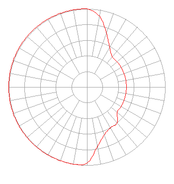 | ||||||||||||||||||
| Azimuth | Ratio | Azimuth | Ratio | Azimuth | Ratio | Azimuth | Ratio | ||||||||||||
| 0 | 1.000 | 10 | 0.916 | 20 | 0.728 | 30 | 0.578 | ||||||||||||
| 40 | 0.503 | 50 | 0.503 | 60 | 0.503 | 70 | 0.503 | ||||||||||||
| 80 | 0.503 | 90 | 0.503 | 100 | 0.503 | 110 | 0.503 | ||||||||||||
| 120 | 0.503 | 130 | 0.503 | 140 | 0.600 | 150 | 0.600 | ||||||||||||
| 160 | 0.649 | 170 | 0.771 | 180 | 0.970 | 190 | 1.000 | ||||||||||||
| 200 | 1.000 | 210 | 1.000 | 220 | 1.000 | 230 | 1.000 | ||||||||||||
| 240 | 1.000 | 250 | 1.000 | 260 | 1.000 | 270 | 1.000 | ||||||||||||
| 280 | 1.000 | 290 | 1.000 | 300 | 1.000 | 310 | 1.000 | ||||||||||||
| 320 | 1.000 | 330 | 1.000 | 340 | 1.000 | 350 | 1.000 | ||||||||||||
Structure Registration Number 1019981 [ASR Heights Differ from WKVH Application] Structure Type: TOWER Registered To: Gray Media Group, Inc. Structure Address: 30 Roddenberry Rd 3.5 Mi Sw Metcalf, GA County Name: Thomas County ASR Issued: 09/09/2020 Date Built: 01/01/1987 Site Elevation: 67.6 m (222 ft.) Structure Height: 587 m (1926 ft.) Height Overall: 609.6 m (2000 ft.) Overall Height AMSL: 677.2 m (2222 ft.) Paint & Light FAA Chapters: A1, B, G, H 30-40-14.0 N 83-56-26.0 W (NAD 83) 30-40-13.3 N 83-56-26.4 W (Converted to NAD 27) |
5700 West Oaks Boulevard Rocklin, CA 95765 Phone: 916-251-1600 Not-for-Profit | Date: 08/02/2005 Application Certifier EDUCATIONAL MEDIA FOUNDATION 5700 West Oaks Blvd Rocklin, CA 95765 Applicant SAM WALLINGTON 5700 West Oaks Blvd Rocklin, CA 95765 DIRECTOR OF ENGINEERING DAVID D. OXENFORD, ESQ Pillsbury Winthrop Shaw Pittman Llp | |||||||||||||||||