
FCCInfo.com
A Service of Cavell, Mertz & Associates, Inc.
(855) FCC-INFO
|
|
|
|
|
||||||||||||||||
|
|
K282BY Channel: 282D 104.3 MHz Salem, Oregon Service: FX - A translator or application for a translator. Facility ID: 201439 Fac. Service: FX Programming Delivery Method: Unspecified Status: License Application Accepted: 04/04/2018 Application Granted: 04/17/2018 File Number: BLFT-20180404AAS License Expires: 00/00/0000 Prefix Type: This is a license for a translator Application Type: License To Cover FCC Website Links: LMS Facility Details This Application CDBS Application Other K282BY Applications Other K282BY Applications in CDBS Including Superseded Applications Mailing Address Correspondence for K282BY Correspondence related to application BLFT-20180404AAS Service Contour - Open Street Map or USGS Map (60 dBu) Service Contour - KML / Google Earth (60 dBu) Class: D, A Noncommercial educational operating with no more than 10W Site Location: 44-59-49.4 N 123-09-16.4 W (NAD 83) Site Location: 44-59-50.0 N 123-09-12.0 W (Converted to NAD 27) Effective Radiated Power: 0.18 kW Transmitter Output Power: 0.071 kW Antenna Center HAAT: 0 m Antenna Center AMSL: 354 m (1161 ft.) Antenna Center HAG: 55 m (180 ft.) Site Elevation: 299 m. (981 ft.) Height Overall*: 61 m (200 ft.) (* As Filed In This Application, may differ from ASR Data, Below.) Directional Antenna Antenna Make/Model: None Antenna ID: 130534 Polarization:
| ||||||||||||||||||
| Antenna Data for Antenna Id: 130534 K282BY FX File: BLFT-20180404AAS None - Service: FX Pattern and Field Values Include a 120° Clockwise Rotation | 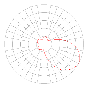 | ||||||||||||||||||
| Azimuth | Ratio | Azimuth | Ratio | Azimuth | Ratio | Azimuth | Ratio | ||||||||||||
| 0 | 0.171 | 10 | 0.187 | 20 | 0.181 | 30 | 0.157 | ||||||||||||
| 40 | 0.142 | 50 | 0.134 | 60 | 0.190 | 70 | 0.329 | ||||||||||||
| 80 | 0.528 | 90 | 0.718 | 100 | 0.866 | 110 | 0.952 | ||||||||||||
| 120 | 1.000 | 130 | 0.952 | 140 | 0.866 | 150 | 0.718 | ||||||||||||
| 160 | 0.528 | 170 | 0.329 | 180 | 0.190 | 190 | 0.134 | ||||||||||||
| 200 | 0.142 | 210 | 0.157 | 220 | 0.181 | 230 | 0.187 | ||||||||||||
| 240 | 0.171 | 250 | 0.140 | 260 | 0.123 | 270 | 0.135 | ||||||||||||
| 280 | 0.160 | 290 | 0.182 | 300 | 0.193 | 310 | 0.182 | ||||||||||||
| 320 | 0.160 | 330 | 0.135 | 340 | 0.123 | 350 | 0.140 | ||||||||||||
Structure Registration Number 1033804 [ASR Heights Differ from K282BY Application] Structure Type: MTOWER Registered To: VB-S1 Assets, LLC Structure Address: Bald Hill Eagle Crest Rd West Salem (us-or-5039) Salem, OR County Name: Polk County ASR Issued: 07/26/2021 Date Built: 01/01/1982 Site Elevation: 301.1 m (988 ft.) Structure Height: 61 m (200 ft.) Height Overall: 67 m (220 ft.) Overall Height AMSL: 368.1 m (1208 ft.) FAA Determination: 10/04/2019 FAA Study #: 2019-ANM-6045-OE FAA Circular #: 70/7460-1L Paint & Light FAA Chapters: 4, 8, 12 PRIOR STUDY 1986-ANM-586-OE 44-59-49.6 N 123-09-14.6 W (NAD 83) 44-59-50.2 N 123-09-10.2 W (Converted to NAD 27) |
3190 Lancaster Drive Ne Salem, OR 97305 Phone: 503-316-1220 | Date: 04/04/2018 Application Certifier KCCS, LLC 3190 Lancaster Drive Ne Salem, OR 97305 Applicant MICHAEL D. BROWN 3740 Sw Comus St Portland, OR 97219-7418 ENGINEERING CONSULTANT MATTHEW H. MCCORMICK Fletcher, Heald & Hildreth, P.l.c. 1300 N 17th Street Suite 1100 Arlington, VA 22209 | |||||||||||||||||