
FCCInfo.com
A Service of Cavell, Mertz & Associates, Inc.
(855) FCC-INFO
|
|
K258DE from 11/26/2013 |
|
|
||||||||||||||||
|
|
K258DE Channel: 258D 99.5 MHz Apple Valley, California Service: FX - A translator or application for a translator. Facility ID: 144710 Fac. Service: FX Programming Delivery Method: Unspecified Status: License Application Accepted: 08/31/2017 Application Granted: 09/06/2017 File Number: BLFT-20170831AAG License Expires: 00/00/0000 Prefix Type: This is a license for a translator Application Type: License To Cover FCC Website Links: LMS Facility Details This Application CDBS Application Other K258DE Applications Other K258DE Applications in CDBS Including Superseded Applications Mailing Address Correspondence for K258DE Correspondence related to application BLFT-20170831AAG Service Contour - Open Street Map or USGS Map (60 dBu) Service Contour - KML / Google Earth (60 dBu) Class: D, A Noncommercial educational operating with no more than 10W Site Location: 34-36-34.0 N 117-17-14.2 W (NAD 83) Site Location: 34-36-34.0 N 117-17-11.0 W (Converted to NAD 27) Effective Radiated Power: 0.19 kW Transmitter Output Power: 0.214 kW Antenna Center HAAT: 0 m Antenna Center AMSL: 1407 m (4616 ft.) Antenna Center HAG: 39 m (128 ft.) Site Elevation: 1368 m. (4488 ft.) Height Overall*: 156 m (512 ft.) (* As Filed In This Application, may differ from ASR Data, Below.) Directional Antenna Antenna Make/Model: None Antenna ID: 126191 Polarization:
| ||||||||||||||||||
| Antenna Data for Antenna Id: 126191 K258DE FX File: BLFT-20170831AAG None - Service: FX Pattern and Field Values Include a 123° Clockwise Rotation | 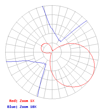 | ||||||||||||||||||
| Azimuth | Ratio | Azimuth | Ratio | Azimuth | Ratio | Azimuth | Ratio | ||||||||||||
| 3 | 0.046 | 13 | 0.037 | 23 | 0.032 | 33 | 0.030 | ||||||||||||
| 43 | 0.045 | 53 | 0.187 | 63 | 0.388 | 73 | 0.570 | ||||||||||||
| 83 | 0.715 | 93 | 0.829 | 103 | 0.920 | 113 | 0.979 | ||||||||||||
| 123 | 1.000 | 133 | 0.979 | 143 | 0.920 | 153 | 0.829 | ||||||||||||
| 163 | 0.715 | 173 | 0.570 | 183 | 0.388 | 193 | 0.187 | ||||||||||||
| 203 | 0.045 | 213 | 0.030 | 223 | 0.032 | 233 | 0.037 | ||||||||||||
| 243 | 0.046 | 253 | 0.065 | 263 | 0.142 | 273 | 0.202 | ||||||||||||
| 283 | 0.234 | 293 | 0.250 | 303 | 0.260 | 313 | 0.250 | ||||||||||||
| 323 | 0.234 | 333 | 0.202 | 343 | 0.142 | 353 | 0.065 | ||||||||||||
Structure Registration Number 1014642 Structure Type: TOWER Registered To: Sunbelt Television, Inc. c/o KAZN-TV Licensee LLC Structure Address: Quartzite Mountain Near Victorville, CA County Name: San Bernardino County ASR Issued: 03/26/2014 Date Built: 02/01/2007 Site Elevation: 1367.6 m (4487 ft.) Structure Height: 156 m (512 ft.) Height Overall: 156 m (512 ft.) Overall Height AMSL: 1523.6 m (4999 ft.) FAA Determination: 01/08/2003 FAA Study #: 2002-AWP-2863-OE FAA Circular #: 70/7460-1K Paint & Light FAA Chapters: 4, 5, 12 Removed expiration date from determination. Scenario 1./jjs/case#635066 34-36-33.9 N 117-17-14.1 W (NAD 83) 34-36-33.9 N 117-17-10.9 W (Converted to NAD 27) |
200 South A Street Suite 400 Oxnard, CA 93030 Phone: 805-240-2070 | Date: 08/31/2017 Application Certifier MAJOR MARKET STATIONS, INC. P.o. Box 10066 Glendale, CA 91209 Applicant FRED W. VOLKEN 348 W. Sierra Madre Blvd. Sierra Madre, CA 91024 ENGINEERING CONSULTANT MARK A. BALKIN Hardy, Carey, Chautin & Balkin, Llp 1080 West Causeway Approach Mandeville, LA 70471 | |||||||||||||||||