
FCCInfo.com
A Service of Cavell, Mertz & Associates, Inc.
(855) FCC-INFO
|
|
W291DC from 11/27/2013 |
|
|
||||||||||||||||
|
|
W291DC Channel: 291D 106.1 MHz Birmingham, Alabama Service: FX - A translator or application for a translator. Facility ID: 150939 Fac. Service: FX Programming Delivery Method: Unspecified Status: License Application Accepted: 01/30/2017 Application Granted: 03/13/2017 File Number: BLFT-20170130ABI License Expires: 00/00/0000 Prefix Type: This is a license for a translator Application Type: License To Cover FCC Website Links: LMS Facility Details This Application CDBS Application Other W291DC Applications Other W291DC Applications in CDBS Including Superseded Applications Mailing Address Correspondence for W291DC Correspondence related to application BLFT-20170130ABI Service Contour - Open Street Map or USGS Map (60 dBu) Service Contour - KML / Google Earth (60 dBu) Class: D, A Noncommercial educational operating with no more than 10W Site Location: 33-29-19.4 N 86-47-58.0 W (NAD 83) Site Location: 33-29-19.0 N 86-47-58.0 W (Converted to NAD 27) Effective Radiated Power: 0.099 kW Transmitter Output Power: 0.245 kW Antenna Center HAAT: 0 m Antenna Center AMSL: 554 m (1818 ft.) Antenna Center HAG: 247 m (810 ft.) Site Elevation: 307 m. (1007 ft.) Height Overall*: 318 m (1043 ft.) (* As Filed In This Application, may differ from ASR Data, Below.) Directional Antenna Antenna Make/Model: None Antenna ID: 16125 Polarization:
| ||||||||||||||||||
| Antenna Data for Antenna Id: 16125 W291DC FX File: BLFT-20170130ABI None - Service: FX Pattern and Field Values Include a 160° Clockwise Rotation | 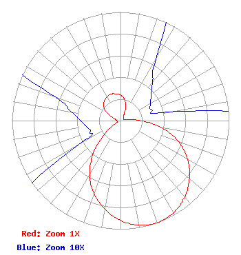 | ||||||||||||||||||
| Azimuth | Ratio | Azimuth | Ratio | Azimuth | Ratio | Azimuth | Ratio | ||||||||||||
| 0 | 0.234 | 10 | 0.202 | 20 | 0.142 | 30 | 0.065 | ||||||||||||
| 40 | 0.046 | 50 | 0.037 | 60 | 0.032 | 70 | 0.030 | ||||||||||||
| 80 | 0.045 | 90 | 0.187 | 100 | 0.388 | 110 | 0.570 | ||||||||||||
| 120 | 0.715 | 130 | 0.829 | 140 | 0.920 | 150 | 0.979 | ||||||||||||
| 160 | 1.000 | 170 | 0.979 | 180 | 0.920 | 190 | 0.829 | ||||||||||||
| 200 | 0.715 | 210 | 0.570 | 220 | 0.388 | 230 | 0.187 | ||||||||||||
| 240 | 0.045 | 250 | 0.030 | 260 | 0.032 | 270 | 0.037 | ||||||||||||
| 280 | 0.046 | 290 | 0.065 | 300 | 0.142 | 310 | 0.202 | ||||||||||||
| 320 | 0.234 | 330 | 0.250 | 340 | 0.260 | 350 | 0.250 | ||||||||||||
Structure Registration Number 1007836 Structure Type: TOWER Registered To: Gray Media Group, Inc. Structure Address: 1720 Valley View Dr Birmingham, AL County Name: Jefferson County ASR Issued: 02/11/2019 Date Built: 01/01/1987 Site Elevation: 306.9 m (1007 ft.) Structure Height: 300 m (984 ft.) Height Overall: 317.6 m (1042 ft.) Overall Height AMSL: 624.5 m (2049 ft.) FAA Determination: 07/31/1987 FAA Study #: 87-ASO-943-OE FAA Circular #: 70/7460-1G Paint & Light FAA Chapters: 4, 5, 6, 7, 9 33-29-19.0 N 86-47-58.0 W (NAD 83) 33-29-18.6 N 86-47-58.0 W (Converted to NAD 27) |
The University Of Alabama At Birmingham 1720 2nd Avenue South Birmingham, AL 35294-0113 Phone: 205-934-227 | Date: 01/30/2017 Application Certifier BOARD OF TRUSTEES OF UNIV OF AL FOR UNIV OF AL AT BIRMINGHAM The University Of Alabama At Birmingham 1720 2nd Avenue South Birmingham, AL 35294-0113 Applicant M. SCOTT JOHNSON Fletcher, Heald & Hildreth, P.l.c. 1300 N. 17th Street, 11th Floor Arlington, VA 22209 JIM TURVAVILLE Turbo Tech Services 360 Patton Street - Po Box 144 Mobeetie, TX 79061-0144 CONSULTING ENGINEER | |||||||||||||||||