
FCCInfo.com
A Service of Cavell, Mertz & Associates, Inc.
(855) FCC-INFO
|
|
|
|  |
|
|||||||||||||||
|
|
WYFS Channel: 208C1 89.5 MHz Savannah, Georgia Service: FM - A full-service FM station or application. Facility ID: 5163 Fac. Service: FM Status: License Application Accepted: 12/06/2017 Application Granted: 12/20/2017 File Number: BLED-20171206AAX License Expires: 00/00/0000 Prefix Type: This is a license for a noncommercial educational FM station Application Type: License To Cover FCC Website Links: LMS Facility Details This Application CDBS Application Other WYFS Applications Other WYFS Applications in CDBS Including Superseded Applications Mailing Address Correspondence for WYFS Correspondence related to application BLED-20171206AAX Service Contour - Open Street Map or USGS Map (60 dBu) Service Contour - KML / Google Earth (60 dBu) Public Inspection Files Facility Type: NON-COMMERCIAL EDUC. FM Class: C1, A Zone II station; with 50kW-100kW ERP and a class contour distance 52km-72km Site Location: 32-03-54.7 N 81-21-05.4 W (NAD 83) Site Location: 32-03-54.0 N 81-21-06.0 W (Converted to NAD 27) Effective Radiated Power: 100 kW Transmitter Output Power: 30.3 kW Antenna Center HAAT: 183 m (600 ft.) Antenna Center AMSL: 191 m (627 ft.) Antenna Center HAG: 185 m (607 ft.) Calculated Site Elevation: 6 m. (20 ft.) Height Overall*: 193.2 m (634 ft.) (* As Filed In This Application, may differ from ASR Data, Below.) Directional Antenna Antenna Make/Model: Electronics Research Inc. MP-6E-DA, six sections Antenna ID: 118739 Polarization:
| ||||||||||||||||||
| Antenna Data for Antenna Id: 118739 WYFS FM File: BLED-20171206AAX Electronics Research Inc. - MP-6E-DA, six sections Service: FM | 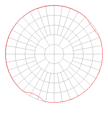 | ||||||||||||||||||
| Azimuth | Ratio | Azimuth | Ratio | Azimuth | Ratio | Azimuth | Ratio | ||||||||||||
| 0 | 1.000 | 10 | 1.000 | 20 | 1.000 | 30 | 1.000 | ||||||||||||
| 40 | 1.000 | 50 | 0.966 | 60 | 0.966 | 70 | 1.000 | ||||||||||||
| 80 | 1.000 | 90 | 1.000 | 100 | 1.000 | 110 | 1.000 | ||||||||||||
| 120 | 1.000 | 130 | 1.000 | 140 | 1.000 | 150 | 1.000 | ||||||||||||
| 160 | 1.000 | 170 | 1.000 | 180 | 1.000 | 190 | 1.000 | ||||||||||||
| 200 | 0.933 | 210 | 0.933 | 220 | 1.000 | 230 | 1.000 | ||||||||||||
| 240 | 1.000 | 250 | 1.000 | 260 | 1.000 | 270 | 1.000 | ||||||||||||
| 280 | 1.000 | 290 | 1.000 | 300 | 1.000 | 310 | 1.000 | ||||||||||||
| 320 | 1.000 | 330 | 1.000 | 340 | 1.000 | 350 | 1.000 | ||||||||||||
Structure Registration Number 1002313 Structure Type: GTOWER Registered To: BIBLE BROADCASTING NETWORK, INC. Structure Address: On Falcon Lane, East Of Fort Argyle Road; 9 Km South Of Bloomingdale, Ga. Bloomingdale, GA County Name: Chatham County ASR Issued: 11/30/2017 Date Built: 01/01/1984 Site Elevation: 6.1 m (20 ft.) Structure Height: 192.3 m (631 ft.) Height Overall: 193.2 m (634 ft.) Overall Height AMSL: 199.3 m (654 ft.) FAA Determination: 09/18/2017 FAA Study #: 2017-ASO-18296-OE FAA Circular #: 70/7460-1L Paint & Light FAA Chapters: 3, 4, 5, 12 PRIOR STUDY 2014-ASO-2467-OE 32-03-55.1 N 81-21-05.1 W (NAD 83) 32-03-54.4 N 81-21-05.7 W (Converted to NAD 27) |
11530 Carmel Commons Blvd Charlotte, NC 28226-3976 Phone: 704-523-5555 Not-for-Profit | Date: 12/06/2017 Application Certifier BIBLE BROADCASTING NETWORK, INC. 11530 Carmel Commons Blvd. Charlotte, NC 28226 Applicant GARY S. SMITHWICK, ESQ. Smithwick & Belendiuk, P.c. JUSTIN ASHER Asher Broadcast Consulting, Llc 579 Babcock Road Bronson, MI 49028-9347 TECHNICAL CONSULTANT | |||||||||||||||||