
FCCInfo.com
A Service of Cavell, Mertz & Associates, Inc.
(855) FCC-INFO
|
|
|
|
|
||||||||||||||||
|
|
K245CW Channel: 245D 96.9 MHz Jonesboro, Arkansas Service: FX - A translator or application for a translator. Facility ID: 200191 Fac. Service: FX Programming Delivery Method: Unspecified Status: License Application Accepted: 02/10/2020 Application Granted: 03/16/2020 File Number: -0000105746 License Expires: 04/01/2028 Application Type: License To Cover FCC Website Links: LMS Facility Details This Application Other K245CW Applications Other K245CW Applications in CDBS Including Superseded Applications Mailing Address Correspondence for K245CW Correspondence related to application -0000105746 Service Contour - Open Street Map or USGS Map (60 dBu) Service Contour - KML / Google Earth (60 dBu) Facility Type: FM STATION Class: D, A Noncommercial educational operating with no more than 10W Site Location: 35-57-14.3 N 90-41-41.4 W (NAD 83) Site Location: 35-57-14.0 N 90-41-41.0 W (Converted to NAD 27) Effective Radiated Power: 0.25 kW Antenna Center HAAT: 0 m Antenna Center AMSL: 432 m (1417 ft.) Antenna Center HAG: 322 m (1056 ft.) Site Elevation: 110 m. (361 ft.) Height Overall*: 326 m (1070 ft.) (* As Filed In This Application, may differ from ASR Data, Below.) Directional Antenna Antenna Make/Model: NIC BKG-77-1 Antenna ID: 130303 Polarization: H
| ||||||||||||||||||
| Antenna Data for Antenna Id: 130303 K245CW FX File: -0000105746 NIC - BKG-77-1 Service: FX | 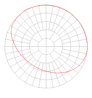 | ||||||||||||||||||
| Azimuth | Ratio | Azimuth | Ratio | Azimuth | Ratio | Azimuth | Ratio | ||||||||||||
| 0 | 0.988 | 10 | 0.983 | 20 | 0.983 | 30 | 0.983 | ||||||||||||
| 40 | 0.983 | 50 | 0.983 | 60 | 0.988 | 70 | 0.988 | ||||||||||||
| 80 | 0.992 | 90 | 1.000 | 100 | 0.991 | 110 | 0.963 | ||||||||||||
| 120 | 0.923 | 130 | 0.862 | 140 | 0.797 | 150 | 0.731 | ||||||||||||
| 160 | 0.676 | 170 | 0.628 | 180 | 0.594 | 190 | 0.571 | ||||||||||||
| 200 | 0.558 | 210 | 0.553 | 220 | 0.558 | 230 | 0.571 | ||||||||||||
| 240 | 0.594 | 250 | 0.628 | 260 | 0.682 | 270 | 0.738 | ||||||||||||
| 280 | 0.815 | 290 | 0.897 | 300 | 0.953 | 310 | 0.973 | ||||||||||||
| 320 | 0.983 | 330 | 1.000 | 340 | 0.992 | 350 | 0.988 | ||||||||||||
Structure Registration Number 1038728 Structure Type: TOWER Registered To: East Arkansas Broadcasters, Inc. Structure Address: 1639 Cr 775 Jonesboro, AR County Name: Craighead County ASR Issued: 05/02/2012 Date Built: 01/01/1987 Site Elevation: 110 m (361 ft.) Structure Height: 326 m (1070 ft.) Height Overall: 326 m (1070 ft.) Overall Height AMSL: 436 m (1430 ft.) FAA Determination: 10/20/1987 FAA Study #: 87-ASW-0343-OE FAA Circular #: 70/7460-1G Paint & Light FAA Chapters: 4, 7, 9 35-57-14.0 N 90-41-41.0 W (NAD 83) 35-57-13.7 N 90-41-40.6 W (Converted to NAD 27) |
P.o. Box 789 2758 Highway 64 Wynne, AR 72396 Phone: 870-238-8141 Limited Liability Company | Title: Managing Member Date: 02/10/2020 Application Certifier EAST ARKANSAS BROADCASTERS OF JONESBORO, LLC East Arkansas Broadcasters Of Jonesboro, Llc P.o. Box 789 2758 Highway 64 Wynne, AR 72396 Applicant Charles M. Anderson Charles M. Anderson & Associates Anderson Communications, Llc 1519 Euclid Avenue Bowling Green, KY 42103 John F. Garziglia Womble Bond Dickinson (us) Llp 1200 19th Street, N.w., Suite 500 Washington, DC 20036 | |||||||||||||||||