
FCCInfo.com
A Service of Cavell, Mertz & Associates, Inc.
(855) FCC-INFO
|
|
|
|  |
|
|||||||||||||||
|
|
WBUR-FM Channel: 215B 90.9 MHz Boston, Massachusetts Service: FS - A full service FM station auxiliary transmitting antenna or application. Facility ID: 68241 Fac. Service: FM Analog & Digital Status: License Application Accepted: 12/18/2019 Application Granted: 12/31/2019 File Number: -0000093001 License Expires: 00/00/0000 Application Type: Converted Amendment FCC Website Links: LMS Facility Details This Application Other WBUR-FM Applications Other WBUR-FM Applications in CDBS Including Superseded Applications Mailing Address Correspondence for WBUR-FM Correspondence related to application -0000093001 Service Contour - Open Street Map or USGS Map (60 dBu) Service Contour - KML / Google Earth (60 dBu) Public Inspection Files History Cards for WBUR-FM Facility Type: NON-COMMERCIAL EDUC. FM Class: B, A Zone I or I-A station; with 25kW-50kW ERP and a class contour distance 39km-52km Site Location: 42-18-27.3 N 71-13-24.9 W (NAD 83) Site Location: 42-18-26.9 N 71-13-26.7 W (Converted to NAD 27) Effective Radiated Power: 11 kW Transmitter Output Power: 7.9 kW Antenna Center HAAT: 305 m (1001 ft.) Antenna Center AMSL: 349.2 m (1146 ft.) Antenna Center HAG: 319 m (1047 ft.) Site Elevation: 30.2 m. (99 ft.) Height Overall*: 381 m (1250 ft.) (* As Filed In This Application, may differ from ASR Data, Below.) Directional Antenna Antenna Make/Model: Shivley 6810-2R-DA Antenna ID: 64755 Polarization:
| ||||||||||||||||||
| Antenna Data for Antenna Id: 64755 WBUR-FM FS File: -0000093001 Shivley - 6810-2R-DA Service: FS | 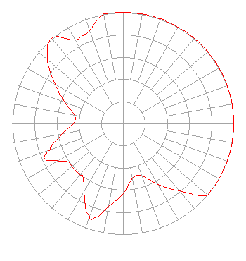 | ||||||||||||||||||
| Azimuth | Ratio | Azimuth | Ratio | Azimuth | Ratio | Azimuth | Ratio | ||||||||||||
| 0 | 1.000 | 10 | 1.000 | 20 | 1.000 | 30 | 1.000 | ||||||||||||
| 40 | 1.000 | 50 | 1.000 | 60 | 1.000 | 70 | 1.000 | ||||||||||||
| 80 | 1.000 | 90 | 1.000 | 100 | 1.000 | 110 | 1.000 | ||||||||||||
| 120 | 1.000 | 130 | 1.000 | 140 | 0.794 | 150 | 0.631 | ||||||||||||
| 160 | 0.501 | 170 | 0.501 | 180 | 0.631 | 190 | 0.759 | ||||||||||||
| 197 | 0.891 | 200 | 0.891 | 210 | 0.708 | 217 | 0.603 | ||||||||||||
| 220 | 0.603 | 230 | 0.603 | 235 | 0.603 | 240 | 0.676 | ||||||||||||
| 246 | 0.776 | 250 | 0.708 | 260 | 0.562 | 270 | 0.447 | ||||||||||||
| 280 | 0.447 | 290 | 0.562 | 300 | 0.708 | 310 | 0.891 | ||||||||||||
| 320 | 1.000 | 330 | 0.871 | 335 | 0.871 | 340 | 0.891 | ||||||||||||
| 350 | 1.000 | ||||||||||||||||||
Structure Registration Number 1004623 [ASR Heights Differ from WBUR-FM Application] Structure Type: GTOWER Registered To: American Towers LLC Structure Address: 1165 Chestnut St ( 001028 ) Newton, MA County Name: Middlesex County ASR Issued: 12/20/2018 Date Built: 10/28/2004 Site Elevation: 28.6 m (94 ft.) Structure Height: 358.7 m (1177 ft.) Height Overall: 381.9 m (1253 ft.) Overall Height AMSL: 410.5 m (1347 ft.) FAA Determination: 12/18/2018 FAA Study #: 2018-ANE-6211-OE FAA Circular #: 70/7460-1L Paint & Light FAA Chapters: 3, 4, 5, 12 42-18-27.8 N 71-13-24.9 W (NAD 83) 42-18-27.4 N 71-13-26.7 W (Converted to NAD 27) |
890 Commonwealth Avenue Boston, MA 02115 Phone: 617-353-0909 Not-for-Profit | Title: Svp, Cfo And Treasurer Date: 12/18/2019 Application Certifier THE TRUSTEES OF BOSTON UNIVERSITY Trustees Of Boston University 890 Commonwealth Avenue Boston, MA 02115 Applicant Stephen T. Lovelady Fletcher, Heald & Hildreth, Plc 1300 North 17th Street Suite 1100 Arlington, VA 22209 Esq MICHAEL LECLAIR The Wbur Group Wbur, Boston University 890 Commonwealth Avenue Boston, MA 02215 CHIEF ENGINEER | |||||||||||||||||
| |||||||||||||||||||