
FCCInfo.com
A Service of Cavell, Mertz & Associates, Inc.
(855) FCC-INFO
|
|
|
|  |
|
|||||||||||||||
|
|
KMTK Channel: 259C2 99.7 MHz Bend, Oregon Service: FM - A full-service FM station or application. Facility ID: 88428 Fac. Service: FM Status: License 73.215 Station Application Accepted: 10/27/2004 Application Granted: 11/18/2004 File Number: BLH-20041027ADJ License Expires: 00/00/0000 Prefix Type: This is a license for a commercial FM station Application Type: Amendment FCC Website Links: LMS Facility Details This Application CDBS Application Other KMTK Applications Other KMTK Applications in CDBS Including Superseded Applications Mailing Address Correspondence for KMTK Correspondence related to application BLH-20041027ADJ Service Contour - Open Street Map or USGS Map (60 dBu) Service Contour - KML / Google Earth (60 dBu) Public Inspection Files Facility Type: FM STATION Class: C2, A Zone II station; with 25kW-50kW ERP and a class contour distance 39km-52km Site Location: 44-04-38.4 N 121-20-01.1 W (NAD 83) Site Location: 44-04-39.0 N 121-19-57.0 W (Converted to NAD 27) Effective Radiated Power: 26 kW Transmitter Output Power: 13 kW Antenna Center HAAT: 208 m (682 ft.) Antenna Center AMSL: 1349 m (4426 ft.) Antenna Center HAG: 66 m (217 ft.) Site Elevation: 1282.6 m. (4208 ft.) Height Overall*: 91.4 m (300 ft.) (* As Filed In This Application, may differ from ASR Data, Below.) Directional Antenna Antenna Make/Model: None Dielectric DCRM-4, 4 section, 0.5 wavelength Antenna ID: 67768 Polarization: | ||||||||||||||||||
| Antenna Data for Antenna Id: 67768 KMTK FM File: BLH-20041027ADJ None - Dielectric DCRM-4, 4 section, 0.5 wavelength Service: FM | 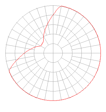 | ||||||||||||||||||
| Azimuth | Ratio | Azimuth | Ratio | Azimuth | Ratio | Azimuth | Ratio | ||||||||||||
| 0 | 0.794 | 10 | 1.000 | 20 | 1.000 | 30 | 1.000 | ||||||||||||
| 40 | 1.000 | 50 | 1.000 | 60 | 1.000 | 70 | 1.000 | ||||||||||||
| 80 | 1.000 | 90 | 1.000 | 100 | 1.000 | 110 | 1.000 | ||||||||||||
| 120 | 1.000 | 130 | 1.000 | 140 | 1.000 | 150 | 1.000 | ||||||||||||
| 160 | 1.000 | 170 | 1.000 | 180 | 1.000 | 190 | 1.000 | ||||||||||||
| 200 | 1.000 | 210 | 1.000 | 220 | 1.000 | 230 | 1.000 | ||||||||||||
| 240 | 1.000 | 247 | 1.000 | 250 | 0.944 | 260 | 0.750 | ||||||||||||
| 270 | 0.596 | 280 | 0.473 | 290 | 0.376 | 300 | 0.299 | ||||||||||||
| 310 | 0.299 | 320 | 0.316 | 330 | 0.398 | 340 | 0.501 | ||||||||||||
| 350 | 0.631 | ||||||||||||||||||
Structure Registration Number 1244492 Structure Type: TOWER Registered To: THE CHACKEL FAMILY, LLC Structure Address: Awbrey Butte Bend, OR County Name: Deschutes County ASR Issued: 07/26/2004 Date Built: 10/23/2004 Site Elevation: 1282.6 m (4208 ft.) Structure Height: 91.4 m (300 ft.) Height Overall: 91.4 m (300 ft.) Overall Height AMSL: 1374 m (4508 ft.) FAA Determination: 07/20/2004 FAA Study #: 2004-ANM-367-OE FAA Circular #: 70/7460-1K Paint & Light FAA Chapters: 3, 4, 5, 12 PRIOR STUDY 2001-ANM-3572-OE 44-04-38.2 N 121-20-00.7 W (NAD 83) 44-04-38.8 N 121-19-56.6 W (Converted to NAD 27) |
P O Box 5037 Bend, OR 97708 Phone: 541-342-3955 | Date: 10/27/2004 Application Certifier COMBINED COMMUNICATIONS, INC. 61425 Tam Mcarthur Loop Bend, OR 97702 Applicant JAMES BODY Boyd Technical Services 21818 Sw Columbia Circle Tualatin, OR 97062 CONSULTING ENGINEER J. DOMINIC MONAHAN Luvaas Cobb | |||||||||||||||||
| |||||||||||||||||||