
FCCInfo.com
A Service of Cavell, Mertz & Associates, Inc.
(855) FCC-INFO
|
|
W228CG from 08/29/2007 W228CG from 07/12/2007 W228CG from 05/26/2004 |
|
|
||||||||||||||||
|
|
W228CG Channel: 228D 93.5 MHz Warwick, New York Service: FX - A translator or application for a translator. Facility ID: 156124 Fac. Service: FX Programming Delivery Method: Unspecified Status: License Application Accepted: 01/31/2011 Application Granted: 02/15/2011 File Number: BLFT-20110131ABJ License Expires: 00/00/0000 Prefix Type: This is a license for a translator Application Type: License To Cover FCC Website Links: LMS Facility Details This Application CDBS Application Other W228CG Applications Other W228CG Applications in CDBS Including Superseded Applications Mailing Address Correspondence for W228CG Correspondence related to application BLFT-20110131ABJ Service Contour - Open Street Map or USGS Map (60 dBu) Service Contour - KML / Google Earth (60 dBu) Class: D, A Noncommercial educational operating with no more than 10W Site Location: 41-16-51.3 N 74-21-44.6 W (NAD 83) Site Location: 41-16-51.0 N 74-21-46.0 W (Converted to NAD 27) Effective Radiated Power: 0.25 kW Transmitter Output Power: 0.48 kW Antenna Center HAAT: 104.8 m Horiz.; 0 m Vert. Antenna Center AMSL: 308 m (1010 ft.) Antenna Center HAG: 58 m (190 ft.) Site Elevation: 250 m. (820 ft.) Height Overall*: 62 m (203 ft.) (* As Filed In This Application, may differ from ASR Data, Below.) Directional Antenna Antenna Make/Model: None Antenna ID: 103592 Polarization:
| ||||||||||||||||||
| Antenna Data for Antenna Id: 103592 W228CG FX File: BLFT-20110131ABJ None - Service: FX | 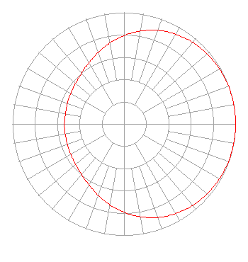 | ||||||||||||||||||
| Azimuth | Ratio | Azimuth | Ratio | Azimuth | Ratio | Azimuth | Ratio | ||||||||||||
| 0 | 0.792 | 10 | 0.845 | 20 | 0.892 | 30 | 0.929 | ||||||||||||
| 40 | 0.956 | 50 | 0.975 | 60 | 0.987 | 70 | 0.995 | ||||||||||||
| 80 | 0.999 | 90 | 1.000 | 100 | 0.999 | 110 | 0.995 | ||||||||||||
| 120 | 0.987 | 130 | 0.975 | 140 | 0.956 | 150 | 0.929 | ||||||||||||
| 160 | 0.892 | 170 | 0.845 | 180 | 0.792 | 190 | 0.735 | ||||||||||||
| 200 | 0.679 | 210 | 0.630 | 220 | 0.592 | 230 | 0.566 | ||||||||||||
| 240 | 0.549 | 250 | 0.540 | 260 | 0.535 | 270 | 0.534 | ||||||||||||
| 280 | 0.532 | 290 | 0.540 | 300 | 0.549 | 310 | 0.566 | ||||||||||||
| 320 | 0.592 | 330 | 0.630 | 340 | 0.679 | 350 | 0.735 | ||||||||||||
Structure Registration Number 1236268 Structure Type: TOWER Registered To: FST Broadcasting Corporation Structure Address: Off West Ridge Road Warwick, NY County Name: Orange County ASR Issued: 10/15/2002 Date Built: 05/29/1969 Site Elevation: 250 m (820 ft.) Structure Height: 61 m (200 ft.) Height Overall: 61.9 m (203 ft.) Overall Height AMSL: 311.9 m (1023 ft.) FAA Determination: 10/08/2002 FAA Study #: 2002-AEA-3343-OE FAA Circular #: 70/7460-1K Paint & Light FAA Chapters: 3, 4, 5, 12 PRIOR STUDY 2002-AEA-2231-OE 41-16-51.3 N 74-21-44.5 W (NAD 83) 41-16-51.0 N 74-21-45.9 W (Converted to NAD 27) |
46 Old Middletown Road Rockaway, NJ 07866 Phone: 845-651-1110 | Date: 01/31/2011 Application Certifier DIGITAL RADIO BROADCASTING, INC. 2927 Us Route 6 Slate Hill, NY 10973 Applicant CHARLES WILLIAMSON Digital Radio Engineering, Inc. 2927 Us Route 6 Slate Hill, NY 10973 PRESIDENT DAVID G. O'NEIL, ESQ. Rini Coran, Pc 1615 L Street N.w. Suite 1325 Washington, DC 20036 | |||||||||||||||||