
FCCInfo.com
A Service of Cavell, Mertz & Associates, Inc.
(855) FCC-INFO
|
|
WQKV from 10/06/2003 WQKV from 01/05/1998 |
|
|
||||||||||||||||
|
|
WQKV Channel: 204B1 88.7 MHz Warsaw, Indiana Service: FM - A full-service FM station or application. Facility ID: 89586 Fac. Service: FM Status: License Application Accepted: 05/05/2014 Application Granted: 06/13/2014 File Number: BLED-20140505ACB License Expires: 00/00/0000 Prefix Type: This is a license for a noncommercial educational FM station Application Type: License To Cover FCC Website Links: LMS Facility Details This Application CDBS Application Other WQKV Applications Other WQKV Applications in CDBS Including Superseded Applications Mailing Address Correspondence for WQKV Correspondence related to application BLED-20140505ACB Service Contour - Open Street Map or USGS Map (60 dBu) Service Contour - KML / Google Earth (60 dBu) Public Inspection Files Facility Type: NON-COMMERCIAL EDUC. FM Class: B1, A Zone I or I-A station; with 6kW-25kW ERP and a class contour distance 28km-39km Site Location: 41-08-20.0 N 85-53-31.0 W (NAD 83) Site Location: 41-08-19.8 N 85-53-31.0 W (Converted to NAD 27) Effective Radiated Power: 15 kW Transmitter Output Power: 7.033 kW Antenna Center HAAT: 82 m (269 ft.) Antenna Center AMSL: 342 m (1122 ft.) Antenna Center HAG: 71 m (233 ft.) Calculated Site Elevation: 271 m. (889 ft.) Height Overall*: 123 m (404 ft.) (* As Filed In This Application, may differ from ASR Data, Below.) Directional Antenna Antenna Make/Model: Electronics Research Inc. LP-4E-DA-HW, 4 section, 0.5 wavelength spaced Antenna ID: 117803 Polarization:
| ||||||||||||||||||
| Antenna Data for Antenna Id: 117803 WQKV FM File: BLED-20140505ACB Electronics Research Inc. - LP-4E-DA-HW, 4 section, 0.5 wavelength spaced Service: FM | 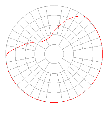 | ||||||||||||||||||
| Azimuth | Ratio | Azimuth | Ratio | Azimuth | Ratio | Azimuth | Ratio | ||||||||||||
| 0 | 0.463 | 10 | 0.583 | 20 | 0.734 | 30 | 0.885 | ||||||||||||
| 40 | 1.000 | 50 | 1.000 | 60 | 1.000 | 70 | 1.000 | ||||||||||||
| 80 | 1.000 | 90 | 1.000 | 100 | 1.000 | 110 | 1.000 | ||||||||||||
| 120 | 1.000 | 130 | 1.000 | 140 | 1.000 | 150 | 1.000 | ||||||||||||
| 160 | 1.000 | 170 | 1.000 | 180 | 1.000 | 190 | 1.000 | ||||||||||||
| 200 | 1.000 | 210 | 1.000 | 220 | 1.000 | 230 | 1.000 | ||||||||||||
| 240 | 1.000 | 250 | 1.000 | 260 | 1.000 | 270 | 0.962 | ||||||||||||
| 280 | 0.764 | 290 | 0.607 | 300 | 0.482 | 310 | 0.383 | ||||||||||||
| 320 | 0.344 | 330 | 0.336 | 340 | 0.343 | 350 | 0.370 | ||||||||||||
Structure Registration Number 1027656 [ASR Heights Differ from WQKV Application] Structure Type: TOWER Registered To: Indiana, State of (IPSC) Structure Address: 6363 S Sr 15 Claypool, IN County Name: Kosciusko County ASR Issued: 01/25/2012 Date Built: 10/18/1996 Site Elevation: 271.3 m (890 ft.) Structure Height: 116 m (381 ft.) Height Overall: 122.5 m (402 ft.) Overall Height AMSL: 393.8 m (1292 ft.) FAA Determination: 10/22/1996 FAA Study #: 96-AGL-3363-OE FAA Circular #: 70/7460-1J Paint & Light FAA Chapters: 3, 4, 5, 13 41-08-20.0 N 85-53-31.0 W (NAD 83) 41-08-19.8 N 85-53-31.0 W (Converted to NAD 27) |
5700 West Oaks Boulevard Rocklin, CA 95765 Phone: 916-251-1600 Not-for-Profit | Date: 05/05/2014 Application Certifier EDUCATIONAL MEDIA FOUNDATION 5700 West Oaks Blvd Rocklin, CA 95765 Applicant SAM WALLINGTON 5700 West Oaks Blvd Rocklin, CA 95765 VP OF ENGINEERING MARY N. O'CONNOR Wilkinson Barker Knauer, Llp | |||||||||||||||||