
FCCInfo.com
A Service of Cavell, Mertz & Associates, Inc.
(855) FCC-INFO
|
|
|
|
|
||||||||||||||||
|
|
W290BG Channel: 290D 105.9 MHz Chattanooga, Tennessee Service: FX - A translator or application for a translator. Facility ID: 143603 Fac. Service: FX Programming Delivery Method: Unspecified Status: License Application Accepted: 10/03/2007 Application Granted: 11/08/2007 File Number: BLFT-20071003ACT License Expires: 00/00/0000 Prefix Type: This is a license for a translator Application Type: License To Cover FCC Website Links: LMS Facility Details This Application CDBS Application Other W290BG Applications Other W290BG Applications in CDBS Including Superseded Applications Mailing Address Correspondence for W290BG Correspondence related to application BLFT-20071003ACT Service Contour - Open Street Map or USGS Map (60 dBu) Service Contour - KML / Google Earth (60 dBu) Class: D, A Noncommercial educational operating with no more than 10W Site Location: 35-07-45.3 N 85-20-01.9 W (NAD 83) Site Location: 35-07-45.0 N 85-20-02.0 W (Converted to NAD 27) Effective Radiated Power: 0.01 kW Transmitter Output Power: 0.015 kW Antenna Center HAAT: 299.5 m Horiz.; 0 m Vert. Antenna Center AMSL: 674 m (2211 ft.) Antenna Center HAG: 100 m (328 ft.) Site Elevation: 574 m. (1883 ft.) Height Overall*: 113 m (371 ft.) (* As Filed In This Application, may differ from ASR Data, Below.) Directional Antenna Antenna Make/Model: None Antenna ID: 16125 Polarization:
| ||||||||||||||||||
| Antenna Data for Antenna Id: 16125 W290BG FX File: BLFT-20071003ACT None - Service: FX Pattern and Field Values Include a 140° Clockwise Rotation | 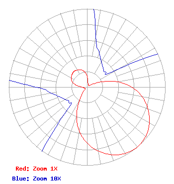 | ||||||||||||||||||
| Azimuth | Ratio | Azimuth | Ratio | Azimuth | Ratio | Azimuth | Ratio | ||||||||||||
| 0 | 0.142 | 10 | 0.065 | 20 | 0.046 | 30 | 0.037 | ||||||||||||
| 40 | 0.032 | 50 | 0.030 | 60 | 0.045 | 70 | 0.187 | ||||||||||||
| 80 | 0.388 | 90 | 0.570 | 100 | 0.715 | 110 | 0.829 | ||||||||||||
| 120 | 0.920 | 130 | 0.979 | 140 | 1.000 | 150 | 0.979 | ||||||||||||
| 160 | 0.920 | 170 | 0.829 | 180 | 0.715 | 190 | 0.570 | ||||||||||||
| 200 | 0.388 | 210 | 0.187 | 220 | 0.045 | 230 | 0.030 | ||||||||||||
| 240 | 0.032 | 250 | 0.037 | 260 | 0.046 | 270 | 0.065 | ||||||||||||
| 280 | 0.142 | 290 | 0.202 | 300 | 0.234 | 310 | 0.250 | ||||||||||||
| 320 | 0.260 | 330 | 0.250 | 340 | 0.234 | 350 | 0.202 | ||||||||||||
Structure Registration Number 1052960 Structure Type: TOWER Registered To: American Towers LLC Structure Address: 574.2us Hwy 127 .5m N Of Signal Mtn (088747 / Signal Mountain) Signal Mountian, TN County Name: Hamilton County ASR Issued: 06/01/2022 Date Built: 10/25/1953 Site Elevation: 574.2 m (1884 ft.) Structure Height: 103.6 m (340 ft.) Height Overall: 112.8 m (370 ft.) Overall Height AMSL: 687 m (2254 ft.) FAA Determination: 03/02/2010 FAA Study #: 2010-ASO-472-OE FAA Circular #: 70/7460-1J Paint & Light FAA Chapters: 4, 5, 6, 8, 13 OM&L to remain the same as prior study = A MED-DUAL SYSTEM 35-07-45.2 N 85-20-01.7 W (NAD 83) 35-07-44.9 N 85-20-01.8 W (Converted to NAD 27) |
5700 West Oaks Blvd Rocklin, CA 95765 Phone: 916-251-1600 | Date: 10/03/2007 Application Certifier EDUCATIONAL MEDIA FOUNDATION 5700 West Oaks Blvd Rocklin, CA 95765 Applicant SAM WALLINGTON 5700 West Oaks Blvd Rocklin, CA 95765 DIRECTOR OF ENGINEERING DAVID D. OXENFORD, ESQ Davis Wright Tremaine Llp 1919 Pennslyvania Ave., Nw Suite 200 Washington, DC 20006 | |||||||||||||||||