
FCCInfo.com
A Service of Cavell, Mertz & Associates, Inc.
(855) FCC-INFO
|
|
K265DF from 01/27/1993 |
|
|
||||||||||||||||
|
|
K265DF Channel: 265D 100.9 MHz Eugene, Oregon Service: FX - A translator or application for a translator. Facility ID: 33071 Fac. Service: FX Programming Delivery Method: Unspecified Status: License Application Accepted: 09/05/2014 Application Granted: 10/06/2014 File Number: BMLFT-20140905ABN License Expires: 00/00/0000 Prefix Type: This is a modification of license for a translator Application Type: Minor Modification FCC Website Links: LMS Facility Details This Application CDBS Application Other K265DF Applications Other K265DF Applications in CDBS Including Superseded Applications Mailing Address Correspondence for K265DF Correspondence related to application BMLFT-20140905ABN Service Contour - Open Street Map or USGS Map (60 dBu) Service Contour - KML / Google Earth (60 dBu) Class: D, A Noncommercial educational operating with no more than 10W Site Location: 44-00-03.4 N 123-06-49.3 W (NAD 83) Site Location: 44-00-04.0 N 123-06-45.0 W (Converted to NAD 27) Effective Radiated Power: 0.25 kW Transmitter Output Power: 0.058 kW Antenna Center HAAT: 0 m Antenna Center AMSL: 505 m (1657 ft.) Antenna Center HAG: 110 m (361 ft.) Site Elevation: 395 m. (1296 ft.) Height Overall*: 199 m (653 ft.) (* As Filed In This Application, may differ from ASR Data, Below.) Directional Antenna Antenna Make/Model: None Antenna ID: 113142 Polarization:
| ||||||||||||||||||
| Antenna Data for Antenna Id: 113142 K265DF FX File: BMLFT-20140905ABN None - Service: FX | 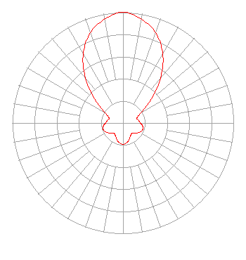 | ||||||||||||||||||
| Azimuth | Ratio | Azimuth | Ratio | Azimuth | Ratio | Azimuth | Ratio | ||||||||||||
| 0 | 1.000 | 10 | 0.952 | 20 | 0.866 | 30 | 0.718 | ||||||||||||
| 40 | 0.528 | 50 | 0.329 | 60 | 0.190 | 70 | 0.134 | ||||||||||||
| 80 | 0.142 | 90 | 0.157 | 100 | 0.181 | 110 | 0.187 | ||||||||||||
| 120 | 0.171 | 130 | 0.140 | 140 | 0.123 | 150 | 0.135 | ||||||||||||
| 160 | 0.160 | 170 | 0.182 | 180 | 0.193 | 190 | 0.182 | ||||||||||||
| 200 | 0.160 | 210 | 0.135 | 220 | 0.123 | 230 | 0.140 | ||||||||||||
| 240 | 0.171 | 250 | 0.187 | 260 | 0.181 | 270 | 0.157 | ||||||||||||
| 280 | 0.142 | 290 | 0.134 | 300 | 0.190 | 310 | 0.329 | ||||||||||||
| 320 | 0.528 | 330 | 0.718 | 340 | 0.866 | 350 | 0.952 | ||||||||||||
Structure Registration Number 1034933 Structure Type: Registered To: EIP Holdings II, LLC Structure Address: 4585 Blanton Rd Eugene, OR County Name: Lane County ASR Issued: 11/30/2023 Date Built: 01/01/1987 Site Elevation: 395 m (1296 ft.) Structure Height: 198.1 m (650 ft.) Height Overall: 199 m (653 ft.) Overall Height AMSL: 594 m (1949 ft.) FAA Determination: 06/04/1990 FAA Study #: 90-ANM-0325-OE FAA Circular #: 70/7460-1G Paint & Light FAA Chapters: 3, 4, 5, 9 44-00-03.0 N 123-06-49.0 W (NAD 83) 44-00-03.6 N 123-06-44.7 W (Converted to NAD 27) |
5700 West Oaks Blvd Rocklin, CA 95765 Phone: 916-251-1600 | Date: 09/05/2014 Application Certifier EDUCATIONAL MEDIA FOUNDATION 5700 West Oaks Blvd Rocklin, CA 95765 Applicant MARY N. O'CONNOR Wilkinson Barker Knauer, Llp 2300 N Street, N.w. Suite 700 Washington, DC 20037 SAM WALLINGTON 5700 West Oaks Blvd Rocklin, CA 95765 VP OF ENGINEERING | |||||||||||||||||