
FCCInfo.com
A Service of Cavell, Mertz & Associates, Inc.
(855) FCC-INFO
|
|
W224CC from 08/30/2004 |
|
|
||||||||||||||||
|
|
W224CC Channel: 224D 92.7 MHz Detroit, Michigan Service: FX - A translator or application for a translator. Facility ID: 148015 Fac. Service: FX Programming Delivery Method: Unspecified Status: License Application Accepted: 05/24/2017 Application Granted: 05/31/2017 File Number: BLFT-20170524ABH License Expires: 00/00/0000 Prefix Type: This is a license for a translator Application Type: License To Cover FCC Website Links: LMS Facility Details This Application CDBS Application Other W224CC Applications Other W224CC Applications in CDBS Including Superseded Applications Mailing Address Correspondence for W224CC Correspondence related to application BLFT-20170524ABH Service Contour - Open Street Map or USGS Map (60 dBu) Service Contour - KML / Google Earth (60 dBu) Class: D, A Noncommercial educational operating with no more than 10W Site Location: 42-26-52.1 N 83-10-22.7 W (NAD 83) Site Location: 42-26-52.0 N 83-10-23.0 W (Converted to NAD 27) Effective Radiated Power: 0.099 kW Transmitter Output Power: 0.236 kW Antenna Center HAAT: 0 m Antenna Center AMSL: 481 m (1578 ft.) Antenna Center HAG: 279 m (915 ft.) Site Elevation: 202 m. (663 ft.) Height Overall*: 331 m (1086 ft.) (* As Filed In This Application, may differ from ASR Data, Below.) Directional Antenna Antenna Make/Model: None Antenna ID: 127301 Polarization:
| ||||||||||||||||||
| Antenna Data for Antenna Id: 127301 W224CC FX File: BLFT-20170524ABH None - Service: FX | 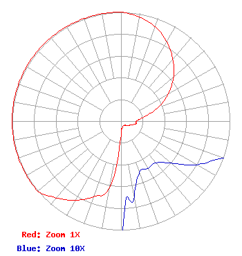 | ||||||||||||||||||
| Azimuth | Ratio | Azimuth | Ratio | Azimuth | Ratio | Azimuth | Ratio | ||||||||||||
| 0 | 1.000 | 10 | 0.969 | 20 | 0.920 | 30 | 0.840 | ||||||||||||
| 40 | 0.740 | 50 | 0.630 | 60 | 0.500 | 70 | 0.360 | ||||||||||||
| 80 | 0.210 | 90 | 0.140 | 100 | 0.140 | 110 | 0.100 | ||||||||||||
| 120 | 0.080 | 130 | 0.060 | 140 | 0.050 | 150 | 0.050 | ||||||||||||
| 160 | 0.050 | 170 | 0.070 | 180 | 0.130 | 190 | 0.630 | ||||||||||||
| 200 | 0.740 | 210 | 0.840 | 220 | 0.920 | 230 | 1.000 | ||||||||||||
| 240 | 1.000 | 250 | 1.000 | 260 | 1.000 | 270 | 1.000 | ||||||||||||
| 280 | 1.000 | 290 | 1.000 | 300 | 1.000 | 310 | 1.000 | ||||||||||||
| 320 | 1.000 | 330 | 1.000 | 340 | 1.000 | 350 | 1.000 | ||||||||||||
Structure Registration Number 1003429 Structure Type: GTOWER Registered To: American Towers LLC Structure Address: 20931 Meyers Rd (282678 / Detroit - Oak Park T1 Mi) Oak Park, MI County Name: Oakland County ASR Issued: 10/14/2016 Date Built: 06/11/1999 Site Elevation: 201.8 m (662 ft.) Structure Height: 308.5 m (1012 ft.) Height Overall: 331.3 m (1087 ft.) Overall Height AMSL: 533.1 m (1749 ft.) FAA Determination: 07/07/2016 FAA Study #: 2016-AGL-8945-OE FAA Circular #: 70/7460-1L Paint & Light FAA Chapters: 4, 9, 12 PRIOR STUDY 2014-AGL-12680-OE 42-26-52.5 N 83-10-23.1 W (NAD 83) 42-26-52.4 N 83-10-23.4 W (Converted to NAD 27) |
4880 Santa Rosa Road Camarillo, CA 93012 Phone: 805-987-0400 | Date: 05/24/2017 Application Certifier CARON BROADCASTING, INC. 4880 Santa Rosa Road Camarillo, CA 93012 Applicant WILLIAM J. GETZ Carl T. Jones Corporation 7901 Yarnwood Ct. Springfield, VA 22153 CONSULTING ENGINEER FRANK R. JAZZO, ESQ. Fletcher, Heald & Hildreth, P.l.c. 1300 N. 17th Street 11th Floor Arlington, VA 22209-3801 | |||||||||||||||||