
FCCInfo.com
A Service of Cavell, Mertz & Associates, Inc.
(855) FCC-INFO
|
|
|
|
|
||||||||||||||||
|
|
W220AA Channel: 220D 91.9 MHz Parlin, Etc., New Jersey Service: FX - A translator or application for a translator. Facility ID: 40054 Fac. Service: FX Programming Delivery Method: Unspecified Status: License Application Accepted: 10/24/2011 Application Granted: 11/03/2011 File Number: BLFT-20111024ABF License Expires: 00/00/0000 Prefix Type: This is a license for a translator Application Type: License To Cover FCC Website Links: LMS Facility Details This Application CDBS Application Other W220AA Applications Other W220AA Applications in CDBS Including Superseded Applications Mailing Address Correspondence for W220AA Correspondence related to application BLFT-20111024ABF Service Contour - Open Street Map or USGS Map (60 dBu) Service Contour - KML / Google Earth (60 dBu) Class: D, A Noncommercial educational operating with no more than 10W Site Location: 40-27-19.4 N 74-17-42.5 W (NAD 83) Site Location: 40-27-19.0 N 74-17-44.0 W (Converted to NAD 27) Effective Radiated Power: 0.01 kW Transmitter Output Power: 0.025 kW Antenna Center HAAT: 87 m Horiz.; 0 m Vert. Antenna Center AMSL: 109 m (358 ft.) Antenna Center HAG: 57 m (187 ft.) Site Elevation: 52 m. (171 ft.) Height Overall*: 69 m (226 ft.) (* As Filed In This Application, may differ from ASR Data, Below.) Directional Antenna Antenna Make/Model: None Antenna ID: 102667 Polarization:
| ||||||||||||||||||
| Antenna Data for Antenna Id: 102667 W220AA FX File: BLFT-20111024ABF None - Service: FX Pattern and Field Values Include a 10° Clockwise Rotation | 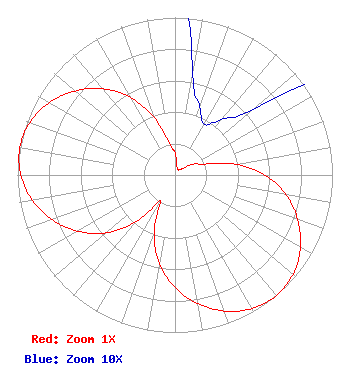 | ||||||||||||||||||
| Azimuth | Ratio | Azimuth | Ratio | Azimuth | Ratio | Azimuth | Ratio | ||||||||||||
| 0 | 0.142 | 10 | 0.065 | 20 | 0.046 | 30 | 0.037 | ||||||||||||
| 40 | 0.046 | 50 | 0.065 | 60 | 0.142 | 70 | 0.202 | ||||||||||||
| 80 | 0.388 | 90 | 0.570 | 100 | 0.715 | 110 | 0.829 | ||||||||||||
| 120 | 0.920 | 130 | 0.979 | 140 | 1.000 | 150 | 0.979 | ||||||||||||
| 160 | 0.920 | 170 | 0.829 | 180 | 0.715 | 190 | 0.570 | ||||||||||||
| 200 | 0.388 | 210 | 0.187 | 220 | 0.388 | 230 | 0.570 | ||||||||||||
| 240 | 0.715 | 250 | 0.829 | 260 | 0.920 | 270 | 0.979 | ||||||||||||
| 280 | 1.000 | 290 | 0.979 | 300 | 0.920 | 310 | 0.829 | ||||||||||||
| 320 | 0.715 | 330 | 0.570 | 340 | 0.388 | 350 | 0.202 | ||||||||||||
Structure Registration Number 1026276 Structure Type: LTOWER Registered To: American Towers LLC Structure Address: 491 Ernston Road (88099) Parlin, NJ County Name: Middlesex County ASR Issued: 01/31/2024 Date Built: 02/17/1966 Site Elevation: 51.8 m (170 ft.) Structure Height: 61.2 m (201 ft.) Height Overall: 68.9 m (226 ft.) Overall Height AMSL: 120.7 m (396 ft.) FAA Determination: 06/02/2023 FAA Study #: 2022-AEA-7071-OE FAA Circular #: 70/7460-1K Paint & Light FAA Chapters: 4, 8, 12 PRIOR STUDY 2009-AEA-2389-OE 40-27-19.2 N 74-17-42.5 W (NAD 83) 40-27-18.8 N 74-17-44.0 W (Converted to NAD 27) |
127 White Oak Lane Old Bridge, NJ 08857 Phone: 888-861-6100 Not-for-Profit | Date: 10/24/2011 Application Certifier BRIDGELIGHT, LLC 127 White Oak Lane Old Bridge, NJ 08857 Applicant ROBERT H BRANCH JR 212 Honey Tree Lane Lynchburg, VA 24502 TECHNICAL CONSULTANT HARRY C. MARTIN, ESQUIRE Fletcher, Heald & Hildreth, Plc 1300 North 17th Street 11th Floor Arlington, VA 22209 | |||||||||||||||||