
FCCInfo.com
A Service of Cavell, Mertz & Associates, Inc.
(855) FCC-INFO
|
|
from 05/30/2019 from 01/19/2010 from 02/15/2002 from 01/06/1997 from 07/15/1985 |
|
|
||||||||||||||||
|
|
WIRO Channel: 296A 107.1 MHz Ironton, Ohio Service: FM - A full-service FM station or application. Facility ID: 61686 Fac. Service: FM Status: License 73.215 Station Application Accepted: 03/22/2019 Application Granted: 06/04/2019 File Number: BMLED-20190322AAD License Expires: 00/00/0000 Prefix Type: This is a modification of license for a noncommercial educational FM station Application Type: Minor Modification FCC Website Links: LMS Facility Details This Application CDBS Application Other WIRO Applications Other WIRO Applications in CDBS Including Superseded Applications Mailing Address Correspondence for WIRO Correspondence related to application BMLED-20190322AAD Service Contour - Open Street Map or USGS Map (60 dBu) Service Contour - KML / Google Earth (60 dBu) Public Inspection Files History Cards for WIRO Facility Type: NON-COMMERCIAL EDUC. FM Class: A, A Zone I; I-A; or II station; with 0.1kW-6kW ERP and a class contour distance <=28km Site Location: 38-31-23.3 N 82-39-10.6 W (NAD 83) Site Location: 38-31-23.0 N 82-39-11.0 W (Converted to NAD 27) Effective Radiated Power: 3.1 kW Transmitter Output Power: 3.1 kW Antenna Center HAAT: 137 m (449 ft.) Antenna Center AMSL: 362 m (1188 ft.) Antenna Center HAG: 100 m (328 ft.) Site Elevation: 262 m. (860 ft.) Height Overall*: 130 m (427 ft.) (* As Filed In This Application, may differ from ASR Data, Below.) Directional Antenna Antenna Make/Model: Electronics Research Inc. LP-2E-DA-HW Antenna ID: 39477 Polarization: | ||||||||||||||||||
| Antenna Data for Antenna Id: 39477 WIRO FM File: BMLED-20190322AAD Electronics Research Inc. - LP-2E-DA-HW Service: FM | 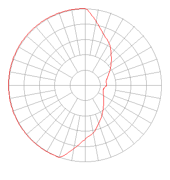 | ||||||||||||||||||
| Azimuth | Ratio | Azimuth | Ratio | Azimuth | Ratio | Azimuth | Ratio | ||||||||||||
| 0 | 1.000 | 10 | 0.841 | 20 | 0.707 | 30 | 0.630 | ||||||||||||
| 40 | 0.530 | 50 | 0.446 | 60 | 0.375 | 70 | 0.316 | ||||||||||||
| 80 | 0.281 | 90 | 0.281 | 100 | 0.250 | 110 | 0.251 | ||||||||||||
| 120 | 0.280 | 130 | 0.316 | 140 | 0.374 | 150 | 0.446 | ||||||||||||
| 160 | 0.530 | 170 | 0.630 | 180 | 0.707 | 190 | 0.841 | ||||||||||||
| 200 | 1.000 | 210 | 1.000 | 220 | 1.000 | 230 | 1.000 | ||||||||||||
| 240 | 1.000 | 250 | 1.000 | 260 | 1.000 | 270 | 1.000 | ||||||||||||
| 280 | 1.000 | 290 | 1.000 | 300 | 1.000 | 310 | 1.000 | ||||||||||||
| 320 | 1.000 | 330 | 1.000 | 340 | 1.000 | 350 | 1.000 | ||||||||||||
Structure Registration Number 1041738 Structure Type: TOWER Registered To: OHIO UNIVERSITY TELECOM CENTER DBA = WOUL FM Structure Address: Polecat Hollow Ironton, OH County Name: Lawrence County ASR Issued: 06/12/2006 Date Built: 01/01/1985 Site Elevation: 262.1 m (860 ft.) Structure Height: 129.8 m (426 ft.) Height Overall: 129.8 m (426 ft.) Overall Height AMSL: 391.9 m (1286 ft.) FAA Determination: 09/09/1997 FAA Study #: 97-AGL-3493-OE FAA Circular #: 70/7460-1J Paint & Light FAA Chapters: 3, 4, 5, 13 38-31-23.0 N 82-39-11.0 W (NAD 83) 38-31-22.7 N 82-39-11.4 W (Converted to NAD 27) |
5700 West Oaks Boulevard Rocklin, CA 95765 Phone: 916-251-1600 Not-for-Profit | Date: 03/22/2019 Application Certifier EDUCATIONAL MEDIA FOUNDATION 5700 West Oaks Blvd. Rocklin, CA 95765 Applicant SAM WALLINGTON 5700 West Oaks Blvd. Rocklin, CA 95765 VP OF OPERATIONS AND ENGINEERING MARY O'CONNOR Wilkinson Barker Knauer, Llp | |||||||||||||||||