
FCCInfo.com
A Service of Cavell, Mertz & Associates, Inc.
(855) FCC-INFO
|
|
|
|
|
||||||||||||||||
|
|
WRCM Channel: 220C2 91.9 MHz Wingate, North Carolina Service: FM - A full-service FM station or application. Facility ID: 12400 Fac. Service: FM Analog & Digital Status: License 73.215 Station Application Accepted: 06/23/2008 Application Granted: 07/10/2008 File Number: BLED-20080623AAF License Expires: 00/00/0000 Prefix Type: This is a license for a noncommercial educational FM station Application Type: License To Cover FCC Website Links: LMS Facility Details This Application CDBS Application Other WRCM Applications Other WRCM Applications in CDBS Including Superseded Applications Mailing Address Correspondence for WRCM Correspondence related to application BLED-20080623AAF Service Contour - Open Street Map or USGS Map (60 dBu) Service Contour - KML / Google Earth (60 dBu) Public Inspection Files Facility Type: NON-COMMERCIAL EDUC. FM Class: C2, A Zone II station; with 25kW-50kW ERP and a class contour distance 39km-52km Site Location: 35-03-34.5 N 80-40-13.2 W (NAD 83) Site Location: 35-03-34.0 N 80-40-14.0 W (Converted to NAD 27) Effective Radiated Power: 30 kW Transmitter Output Power: 11 kW Antenna Center HAAT: 151 m (495 ft.) Antenna Center AMSL: 353 m (1158 ft.) Antenna Center HAG: 151 m (495 ft.) Calculated Site Elevation: 202 m. (663 ft.) Height Overall*: 157.1 m (515 ft.) (* As Filed In This Application, may differ from ASR Data, Below.) Directional Antenna Antenna Make/Model: Electronics Research Inc. MP-3E-DA, Three sections, full wavelength spaced Antenna ID: 85830 Polarization: | ||||||||||||||||||
| Antenna Data for Antenna Id: 85830 WRCM FM File: BLED-20080623AAF Electronics Research Inc. - MP-3E-DA, Three sections, full wavelength spaced Service: FM | 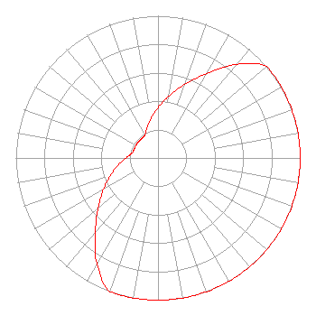 | ||||||||||||||||||
| Azimuth | Ratio | Azimuth | Ratio | Azimuth | Ratio | Azimuth | Ratio | ||||||||||||
| 0 | 0.354 | 10 | 0.442 | 20 | 0.550 | 30 | 0.686 | ||||||||||||
| 40 | 0.860 | 50 | 1.000 | 60 | 1.000 | 70 | 1.000 | ||||||||||||
| 80 | 1.000 | 90 | 1.000 | 100 | 1.000 | 110 | 1.000 | ||||||||||||
| 120 | 1.000 | 130 | 1.000 | 140 | 1.000 | 150 | 1.000 | ||||||||||||
| 160 | 1.000 | 170 | 1.000 | 180 | 1.000 | 190 | 1.000 | ||||||||||||
| 200 | 1.000 | 210 | 0.860 | 220 | 0.686 | 230 | 0.550 | ||||||||||||
| 240 | 0.442 | 250 | 0.354 | 260 | 0.283 | 270 | 0.226 | ||||||||||||
| 280 | 0.187 | 290 | 0.179 | 300 | 0.179 | 310 | 0.179 | ||||||||||||
| 320 | 0.179 | 330 | 0.187 | 340 | 0.226 | 350 | 0.283 | ||||||||||||
Structure Registration Number 1007213 [ASR Heights Differ from WRCM Application] Structure Type: Registered To: Educational Media Foundation Structure Address: 1092 Radio Dr Indian Trail, NC County Name: Union County ASR Issued: 09/29/2015 Date Built: 04/27/1993 Site Elevation: 202.6 m (665 ft.) Structure Height: 156 m (512 ft.) Height Overall: 157.1 m (515 ft.) Overall Height AMSL: 359.7 m (1180 ft.) FAA Determination: 01/22/1997 FAA Study #: 97-ASO-0026-OE FAA Circular #: 70/7460-1J Paint & Light FAA Chapters: 3, 4, 5, 13 35-03-35.0 N 80-40-13.0 W (NAD 83) 35-03-34.5 N 80-40-13.8 W (Converted to NAD 27) |
5700 West Oaks Blvd. Rocklin, CA 95765 Phone: 916-251-1600 Not-for-Profit | Date: 06/23/2008 Application Certifier COLUMBIA BIBLE COLLEGE BROADCASTING CO. P O Box 3122 7435 Monticello Rd Columbia, SC 29230-3122 Applicant JAMES D. MORRISON C/o Wmhk P O Box 3122 Columbia, SC 29230-3122 TECHNICAL DIRECTOR JAMES D. MORRISON Columbia Bible College Broadcasting Co. | |||||||||||||||||