
FCCInfo.com
A Service of Cavell, Mertz & Associates, Inc.
(855) FCC-INFO
|
|
|
|
|
||||||||||||||||
|
|
K294CD Channel: 294D 106.7 MHz Pocatello, Idaho Service: FX - A translator or application for a translator. Facility ID: 152582 Fac. Service: FX Programming Delivery Method: Unspecified Status: License Application Accepted: 02/02/2015 Application Granted: 02/18/2015 File Number: BLFT-20150202AEQ License Expires: 00/00/0000 Prefix Type: This is a license for a translator Application Type: License To Cover FCC Website Links: LMS Facility Details This Application CDBS Application Other K294CD Applications Other K294CD Applications in CDBS Including Superseded Applications Mailing Address Correspondence for K294CD Correspondence related to application BLFT-20150202AEQ Service Contour - Open Street Map or USGS Map (60 dBu) Service Contour - KML / Google Earth (60 dBu) Class: D, A Noncommercial educational operating with no more than 10W Site Location: 42-51-45.7 N 112-31-05.9 W (NAD 83) Site Location: 42-51-46.0 N 112-31-03.0 W (Converted to NAD 27) Effective Radiated Power: 0.25 kW Transmitter Output Power: 0.077 kW Antenna Center HAAT: 0 m Antenna Center AMSL: 1838 m (6030 ft.) Antenna Center HAG: 58 m (190 ft.) Site Elevation: 1780 m. (5840 ft.) Height Overall*: 106 m (348 ft.) (* As Filed In This Application, may differ from ASR Data, Below.) Directional Antenna Antenna Make/Model: None Antenna ID: 16149 Polarization:
| ||||||||||||||||||
| Antenna Data for Antenna Id: 16149 K294CD FX File: BLFT-20150202AEQ None - Service: FX Pattern and Field Values Include a 80° Clockwise Rotation | 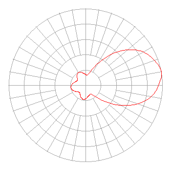 | ||||||||||||||||||
| Azimuth | Ratio | Azimuth | Ratio | Azimuth | Ratio | Azimuth | Ratio | ||||||||||||
| 0 | 0.142 | 10 | 0.134 | 20 | 0.190 | 30 | 0.329 | ||||||||||||
| 40 | 0.528 | 50 | 0.718 | 60 | 0.866 | 70 | 0.952 | ||||||||||||
| 80 | 1.000 | 90 | 0.952 | 100 | 0.866 | 110 | 0.718 | ||||||||||||
| 120 | 0.528 | 130 | 0.329 | 140 | 0.190 | 150 | 0.134 | ||||||||||||
| 160 | 0.142 | 170 | 0.157 | 180 | 0.181 | 190 | 0.187 | ||||||||||||
| 200 | 0.171 | 210 | 0.140 | 220 | 0.123 | 230 | 0.135 | ||||||||||||
| 240 | 0.160 | 250 | 0.182 | 260 | 0.193 | 270 | 0.182 | ||||||||||||
| 280 | 0.160 | 290 | 0.135 | 300 | 0.123 | 310 | 0.140 | ||||||||||||
| 320 | 0.171 | 330 | 0.187 | 340 | 0.181 | 350 | 0.157 | ||||||||||||
Structure Registration Number 1213130 Structure Type: TOWER Registered To: Idaho Wireless Inc Structure Address: On Howard Mountain West Of Pocatello 1/2 Mile Pocatello, ID County Name: Power County ASR Issued: 08/03/2005 Date Built: 11/26/1994 Site Elevation: 1780 m (5840 ft.) Structure Height: 105 m (344 ft.) Height Overall: 106 m (348 ft.) Overall Height AMSL: 1886 m (6188 ft.) FAA Determination: 06/24/2004 FAA Study #: 2004-ANM-352-OE FAA Circular #: 70/7460-1K Paint & Light FAA Chapters: 3, 4, 5, 12 PRIOR STUDY 2000-ANM-50-OE 42-51-45.6 N 112-31-05.9 W (NAD 83) 42-51-45.9 N 112-31-03.0 W (Converted to NAD 27) |
P.o. Box 97 Pocatello, ID 83204-0097 Phone: 208-234-1290 | Date: 02/02/2015 Application Certifier IDAHO WIRELESS CORPORATION P.o. Box 97 Pocatello, ID 83204-0097 Applicant A. WRAY FITCH III Gammon & Grange, P.c. 8280 Greensboro Drive, 7th Floor Mclean, VA 22102 WESTON MCCARRON 160 Gooding St West Suite A Twin Falls, ID 83301 CONSULTING ENGINEER | |||||||||||||||||