
FCCInfo.com
A Service of Cavell, Mertz & Associates, Inc.
(855) FCC-INFO
|
|
|
|
|
||||||||||||||||
|
|
W282AY Channel: 282D 104.3 MHz Chattanooga, Tennessee Service: FX - A translator or application for a translator. Facility ID: 153296 Fac. Service: FX Programming Delivery Method: Unspecified Status: License Application Accepted: 10/22/2012 Application Granted: 11/20/2012 File Number: BLFT-20121022AAA License Expires: 00/00/0000 Prefix Type: This is a license for a translator Application Type: License To Cover FCC Website Links: LMS Facility Details This Application CDBS Application Other W282AY Applications Other W282AY Applications in CDBS Including Superseded Applications Mailing Address Correspondence for W282AY Correspondence related to application BLFT-20121022AAA Service Contour - Open Street Map or USGS Map (60 dBu) Service Contour - KML / Google Earth (60 dBu) Class: D, A Noncommercial educational operating with no more than 10W Site Location: 35-07-45.3 N 85-20-01.9 W (NAD 83) Site Location: 35-07-45.0 N 85-20-02.0 W (Converted to NAD 27) Effective Radiated Power: 0 kW Horiz. ; 0.05 kW Vert. Transmitter Output Power: 0.05 kW Antenna Center HAAT: 283.5 m Horiz.; 0 m Vert. Antenna Center AMSL: 0 m Horiz.; 658 m Vert. Antenna Center HAG: 0 m Horiz.; 84 m Vert. Site Elevation: 574 m. (1883 ft.) Height Overall*: 113 m (371 ft.) (* As Filed In This Application, may differ from ASR Data, Below.) Directional Antenna Antenna Make/Model: None Antenna ID: 109765 Polarization:
| ||||||||||||||||||
| Antenna Data for Antenna Id: 109765 W282AY FX File: BLFT-20121022AAA None - Service: FX | 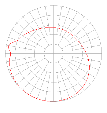 | ||||||||||||||||||
| Azimuth | Ratio | Azimuth | Ratio | Azimuth | Ratio | Azimuth | Ratio | ||||||||||||
| 0 | 0.540 | 10 | 0.535 | 20 | 0.534 | 30 | 0.535 | ||||||||||||
| 40 | 0.540 | 50 | 0.549 | 60 | 0.566 | 70 | 0.592 | ||||||||||||
| 80 | 0.630 | 90 | 0.679 | 100 | 0.735 | 110 | 0.792 | ||||||||||||
| 120 | 0.845 | 130 | 0.892 | 140 | 0.929 | 150 | 0.956 | ||||||||||||
| 160 | 0.975 | 170 | 0.987 | 180 | 0.995 | 190 | 0.999 | ||||||||||||
| 200 | 1.000 | 210 | 0.999 | 220 | 0.995 | 230 | 0.987 | ||||||||||||
| 240 | 0.975 | 250 | 0.956 | 260 | 0.929 | 270 | 0.892 | ||||||||||||
| 280 | 0.945 | 290 | 0.792 | 300 | 0.735 | 310 | 0.679 | ||||||||||||
| 320 | 0.630 | 330 | 0.592 | 340 | 0.566 | 350 | 0.549 | ||||||||||||
Structure Registration Number 1052960 Structure Type: TOWER Registered To: American Towers LLC Structure Address: 574.2us Hwy 127 .5m N Of Signal Mtn (088747 / Signal Mountain) Signal Mountian, TN County Name: Hamilton County ASR Issued: 06/01/2022 Date Built: 10/25/1953 Site Elevation: 574.2 m (1884 ft.) Structure Height: 103.6 m (340 ft.) Height Overall: 112.8 m (370 ft.) Overall Height AMSL: 687 m (2254 ft.) FAA Determination: 03/02/2010 FAA Study #: 2010-ASO-472-OE FAA Circular #: 70/7460-1J Paint & Light FAA Chapters: 4, 5, 6, 8, 13 OM&L to remain the same as prior study = A MED-DUAL SYSTEM 35-07-45.2 N 85-20-01.7 W (NAD 83) 35-07-44.9 N 85-20-01.8 W (Converted to NAD 27) |
670 Lafayette Street Ringgold, GA 30736 Phone: 706-935-2201 Corporation | Date: 10/22/2012 Application Certifier IMMANUEL BROADCASTING NETWORK, INC. P.o.box 1000 Cartersville, GA 30120 Applicant NEIL HOPPER Po Box 1000 Cartersville, GA 30120 DIRECTOR OF OPERATIONS NEIL HOPPER Immanuel Broadcasting Network P.o. Box 1000 Cartersville, GA 30120 | |||||||||||||||||