
FCCInfo.com
A Service of Cavell, Mertz & Associates, Inc.
(855) FCC-INFO
|
|
KAIA from 11/27/2002 KAIA from 06/26/1995 |
|
|
||||||||||||||||
|
|
KAIA Channel: 218C2 91.5 MHz Bloomfield, Missouri Service: FM - A full-service FM station or application. Facility ID: 76841 Fac. Service: FM Status: License Application Accepted: 08/22/2017 Application Granted: 09/19/2017 File Number: BMLED-20170822AAD License Expires: 00/00/0000 Prefix Type: This is a modification of license for a noncommercial educational FM station Application Type: Minor Modification FCC Website Links: LMS Facility Details This Application CDBS Application Other KAIA Applications Other KAIA Applications in CDBS Including Superseded Applications Mailing Address Correspondence for KAIA Correspondence related to application BMLED-20170822AAD Service Contour - Open Street Map or USGS Map (60 dBu) Service Contour - KML / Google Earth (60 dBu) Public Inspection Files Facility Type: NON-COMMERCIAL EDUC. FM Class: C2, A Zone II station; with 25kW-50kW ERP and a class contour distance 39km-52km Site Location: 36-40-31.2 N 89-46-19.3 W (NAD 83) Site Location: 36-40-31.0 N 89-46-19.0 W (Converted to NAD 27) Effective Radiated Power: 0 kW Horiz. ; 49 kW Vert. Transmitter Output Power: 10.89 kW Antenna Center HAAT: 0 m Horiz.; 127 m Vert. Antenna Center AMSL: 0 m Horiz.; 211 m Vert. Antenna Center HAG: 0 m Horiz.; 124 m Vert. Calculated Site Elevation: m. Height Overall*: 152 m (499 ft.) (* As Filed In This Application, may differ from ASR Data, Below.) Directional Antenna Antenna Make/Model: Electronics Research Inc. P300-3BE-DA, THREE SECTIONS Antenna ID: 80912 Polarization:
| ||||||||||||||||||
| Antenna Data for Antenna Id: 80912 KAIA FM File: BMLED-20170822AAD Electronics Research Inc. - P300-3BE-DA, THREE SECTIONS Service: FM | 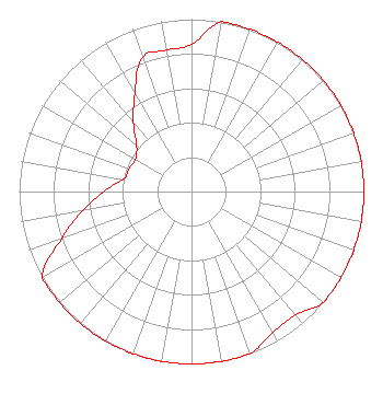 | ||||||||||||||||||
| Azimuth | Ratio | Azimuth | Ratio | Azimuth | Ratio | Azimuth | Ratio | ||||||||||||
| 0 | 0.853 | 10 | 1.000 | 20 | 1.000 | 30 | 1.000 | ||||||||||||
| 40 | 1.000 | 50 | 1.000 | 60 | 1.000 | 70 | 1.000 | ||||||||||||
| 80 | 1.000 | 90 | 1.000 | 100 | 1.000 | 110 | 1.000 | ||||||||||||
| 120 | 1.000 | 130 | 1.000 | 140 | 0.936 | 150 | 0.943 | ||||||||||||
| 160 | 1.000 | 170 | 1.000 | 180 | 1.000 | 190 | 1.000 | ||||||||||||
| 200 | 1.000 | 210 | 1.000 | 220 | 1.000 | 230 | 1.000 | ||||||||||||
| 240 | 1.000 | 250 | 0.804 | 260 | 0.639 | 270 | 0.508 | ||||||||||||
| 280 | 0.403 | 290 | 0.387 | 300 | 0.376 | 310 | 0.416 | ||||||||||||
| 320 | 0.524 | 330 | 0.659 | 340 | 0.830 | 350 | 0.833 | ||||||||||||
Structure Registration Number 1058497 [ASR Heights Differ from KAIA Application] Structure Type: TOWER Registered To: MRR License LLC Structure Address: 0.4 Km N Of Route Z, 3.4 Km E Of Route 153 Hills Store, MO County Name: Stoddard County ASR Issued: 02/24/2005 Date Built: 02/18/1999 Site Elevation: 86.9 m (285 ft.) Structure Height: 151.5 m (497 ft.) Height Overall: 152.4 m (500 ft.) Overall Height AMSL: 239.3 m (785 ft.) FAA Determination: 10/07/1998 FAA Study #: 98-ACE-1247-OE FAA Circular #: 70/7460-1J Paint & Light FAA Chapters: 3, 4, 5, 13 REACHED GREATEST HEIGHT AS APPROVED ON 02/18/99. 36-40-31.0 N 89-46-19.0 W (NAD 83) 36-40-30.8 N 89-46-18.7 W (Converted to NAD 27) |
5700 West Oaks Blvd Rocklin, CA 95765 Phone: 916-251-1600 Not-for-Profit | Date: 08/22/2017 Application Certifier EDUCATIONAL MEDIA FOUNDATION 5700 West Oaks Blvd Rocklin, CA 95765 Applicant STEPHEN WILDE 5700 West Oaks Blvd Rocklin, CA 95765 RF DESIGN ENGINEER MARY O'CONNOR Wilkinson Barker Knauer, Llp | |||||||||||||||||