
FCCInfo.com
A Service of Cavell, Mertz & Associates, Inc.
(855) FCC-INFO
|
|
|
|
|
||||||||||||||||
|
|
K290CE Channel: 290D 105.9 MHz Pocatello, Idaho Service: FX - A translator or application for a translator. Facility ID: 142207 Fac. Service: FX Programming Delivery Method: Unspecified Status: License Application Accepted: 03/17/2015 Application Granted: 03/30/2015 File Number: BLFT-20150317ABC License Expires: 00/00/0000 Prefix Type: This is a license for a translator Application Type: License To Cover FCC Website Links: LMS Facility Details This Application CDBS Application Other K290CE Applications Other K290CE Applications in CDBS Including Superseded Applications Mailing Address Correspondence for K290CE Correspondence related to application BLFT-20150317ABC Service Contour - Open Street Map or USGS Map (60 dBu) Service Contour - KML / Google Earth (60 dBu) Class: D, A Noncommercial educational operating with no more than 10W Site Location: 42-55-12.7 N 112-20-47.9 W (NAD 83) Site Location: 42-55-13.0 N 112-20-45.0 W (Converted to NAD 27) Effective Radiated Power: 0.25 kW Transmitter Output Power: 0.63 kW Antenna Center HAAT: 0 m Antenna Center AMSL: 1951 m (6401 ft.) Antenna Center HAG: 50 m (164 ft.) Site Elevation: 1901 m. (6237 ft.) Height Overall*: 110 m (361 ft.) (* As Filed In This Application, may differ from ASR Data, Below.) Directional Antenna Antenna Make/Model: None Antenna ID: 119965 Polarization:
| ||||||||||||||||||
| Antenna Data for Antenna Id: 119965 K290CE FX File: BLFT-20150317ABC None - Service: FX | 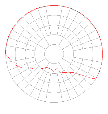 | ||||||||||||||||||
| Azimuth | Ratio | Azimuth | Ratio | Azimuth | Ratio | Azimuth | Ratio | ||||||||||||
| 0 | 1.000 | 10 | 1.000 | 20 | 1.000 | 30 | 1.000 | ||||||||||||
| 40 | 1.000 | 50 | 1.000 | 60 | 1.000 | 70 | 1.000 | ||||||||||||
| 80 | 1.000 | 90 | 1.000 | 100 | 1.000 | 110 | 1.000 | ||||||||||||
| 120 | 1.000 | 130 | 0.633 | 140 | 0.494 | 150 | 0.445 | ||||||||||||
| 160 | 0.394 | 170 | 0.302 | 180 | 0.361 | 190 | 0.326 | ||||||||||||
| 200 | 0.314 | 210 | 0.324 | 220 | 0.397 | 230 | 0.486 | ||||||||||||
| 240 | 0.581 | 250 | 0.776 | 260 | 0.859 | 270 | 1.000 | ||||||||||||
| 280 | 1.000 | 290 | 1.000 | 300 | 1.000 | 310 | 1.000 | ||||||||||||
| 320 | 1.000 | 330 | 1.000 | 340 | 1.000 | 350 | 1.000 | ||||||||||||
Structure Registration Number 1248120 Structure Type: Registered To: VB-S1 Assets, LLC Structure Address: 5 Miles Ne Of Pocatello, ID County Name: Bannock County ASR Issued: 01/31/2018 Date Built: 09/21/2010 Site Elevation: 1901.3 m (6238 ft.) Structure Height: 94.5 m (310 ft.) Height Overall: 110.3 m (362 ft.) Overall Height AMSL: 2011.6 m (6600 ft.) FAA Determination: 09/13/2010 FAA Study #: 2010-ANM-1917-OE Paint & Light FAA Chapters: NONE PRIOR STUDY 2005-ANM-581-OE 42-55-12.5 N 112-20-47.6 W (NAD 83) 42-55-12.8 N 112-20-44.7 W (Converted to NAD 27) |
400 West Sunnyside Road Idaho Falls, ID 83402 Phone: 208-535-8305 Limited Liability Company | Date: 03/17/2015 Application Certifier RIVERBEND COMMUNICATIONS, LLC 400 W. Sunnyside Road Idaho Falls, ID 83402 Applicant GENE WISNIEWSKI 1472 East 3100 South Wendell, ID 83355 CONSULTING ENGINEER SUSAN A. MARSHALL Fletcher Heald & Hildreth, P.l.c. 1300 N. 17th Street 11th Floor Arlington, VA 22209 | |||||||||||||||||