
FCCInfo.com
A Service of Cavell, Mertz & Associates, Inc.
(855) FCC-INFO
|
|
W291DD from 08/26/2016 W291DD from 01/07/2016 |
|
|
||||||||||||||||
|
|
W291DD Channel: 291D 106.1 MHz Lexington, North Carolina Service: FX - A translator or application for a translator. Facility ID: 138258 Fac. Service: FX Programming Delivery Method: Unspecified Status: License Application Accepted: 12/19/2018 Application Granted: 12/21/2018 File Number: BLFT-20181219AAQ License Expires: 12/01/2027 Prefix Type: This is a license for a translator Application Type: License To Cover FCC Website Links: LMS Facility Details This Application CDBS Application Other W291DD Applications Other W291DD Applications in CDBS Including Superseded Applications Mailing Address Correspondence for W291DD Correspondence related to application BLFT-20181219AAQ Service Contour - Open Street Map or USGS Map (60 dBu) Service Contour - KML / Google Earth (60 dBu) Class: D, A Noncommercial educational operating with no more than 10W Site Location: 36-05-25.1 N 80-15-05.1 W (NAD 83) Site Location: 36-05-24.6 N 80-15-05.9 W (Converted to NAD 27) Effective Radiated Power: 0.25 kW Transmitter Output Power: 0.172 kW Antenna Center HAAT: 0 m Antenna Center AMSL: 360 m (1181 ft.) Antenna Center HAG: 87 m (285 ft.) Site Elevation: 273 m. (896 ft.) Height Overall*: 105 m (344 ft.) (* As Filed In This Application, may differ from ASR Data, Below.) Directional Antenna Antenna Make/Model: Shivley 6812-B Antenna ID: 133284 Polarization: H
| ||||||||||||||||||
| Antenna Data for Antenna Id: 133284 W291DD FX File: BLFT-20181219AAQ Shivley - 6812-B Service: FX | 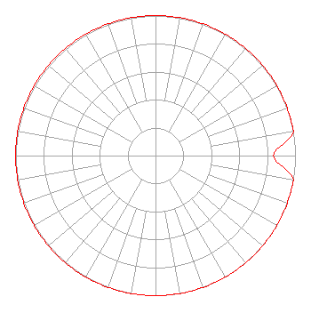 | ||||||||||||||||||
| Azimuth | Ratio | Azimuth | Ratio | Azimuth | Ratio | Azimuth | Ratio | ||||||||||||
| 0 | 1.000 | 10 | 1.000 | 20 | 1.000 | 30 | 1.000 | ||||||||||||
| 40 | 1.000 | 50 | 1.000 | 60 | 1.000 | 70 | 1.000 | ||||||||||||
| 80 | 1.000 | 90 | 0.843 | 100 | 1.000 | 110 | 1.000 | ||||||||||||
| 120 | 1.000 | 130 | 1.000 | 140 | 1.000 | 150 | 1.000 | ||||||||||||
| 160 | 1.000 | 170 | 1.000 | 180 | 1.000 | 190 | 1.000 | ||||||||||||
| 200 | 1.000 | 210 | 1.000 | 220 | 1.000 | 230 | 1.000 | ||||||||||||
| 240 | 1.000 | 250 | 1.000 | 260 | 1.000 | 270 | 1.000 | ||||||||||||
| 280 | 1.000 | 290 | 1.000 | 300 | 1.000 | 310 | 1.000 | ||||||||||||
| 320 | 1.000 | 330 | 1.000 | 340 | 1.000 | 350 | 1.000 | ||||||||||||
Structure Registration Number 1012292 Structure Type: LTOWER Registered To: American Towers, LLC Structure Address: 233 S Green St (306491) Winston Salem, NC County Name: Forsyth County ASR Issued: 02/07/2020 Date Built: 01/13/1995 Site Elevation: 272.8 m (895 ft.) Structure Height: 100.6 m (330 ft.) Height Overall: 105.2 m (345 ft.) Overall Height AMSL: 378 m (1240 ft.) FAA Determination: 03/24/2015 FAA Study #: 2015-ASO-2885-OE FAA Circular #: 70/7460-1J Paint & Light FAA Chapters: 4, 5, 6, 8, 13 OM&L to remain the same as prior study = A MED-DUAL SYSTEM 36-05-25.1 N 80-15-05.1 W (NAD 83) 36-05-24.6 N 80-15-05.9 W (Converted to NAD 27) |
Blacksburg, VA 24063 Phone: 540-552-4281 Not-for-Profit | Date: 12/19/2018 Application Certifier DAVIDSON COUNTY BROADCASTING CO., INC. 200 Radio Drive Lexington, NC 27292 Applicant RICHARD S. GRAHAM Graham Brock, Inc. P.o. Box 24466 St. Simons Island, GA 31522-7466 TECHNICAL CONSULTANT GARY S. SMITHWICK, ESQ. Smithwick & Belendiuk, P.c. 5028 Wisconsin Ave., N.w. Suite 301 Washington, DC 20016 | |||||||||||||||||