
FCCInfo.com
A Service of Cavell, Mertz & Associates, Inc.
(855) FCC-INFO
|
|
|
|
|
||||||||||||||||
|
|
KXBN-FM1 Channel: 221D 92.1 MHz St. George, Utah Service: FB - A booster station or application for a booster. Facility ID: 178302 Fac. Service: FB Programming Delivery Method: Unspecified Status: License Application Accepted: 06/04/2009 Application Granted: 06/08/2009 File Number: BLFTB-20090604ABK License Expires: 00/00/0000 Prefix Type: This is a license for a booster Application Type: License To Cover FCC Website Links: LMS Facility Details This Application CDBS Application Other KXBN-FM1 Applications Other KXBN-FM1 Applications in CDBS Including Superseded Applications Mailing Address Correspondence for KXBN-FM1 Correspondence related to application BLFTB-20090604ABK Service Contour - Open Street Map or USGS Map (60 dBu) Service Contour - KML / Google Earth (60 dBu) Facility Type: FM STATION Class: D, A Noncommercial educational operating with no more than 10W Site Location: 37-03-48.8 N 113-34-31.9 W (NAD 83) Site Location: 37-03-48.9 N 113-34-29.1 W (Converted to NAD 27) Effective Radiated Power: 3.5 kW Horiz. ; 0.01 kW Vert. Transmitter Output Power: 1.024 kW Antenna Center HAAT: 0 m Antenna Center AMSL: 962 m (3156 ft.) Antenna Center HAG: 29 m (95 ft.) Site Elevation: 933 m. (3061 ft.) Height Overall*: 34 m (112 ft.) (* As Filed In This Application, may differ from ASR Data, Below.) Directional Antenna Antenna Make/Model: None Antenna ID: 88259 Polarization:
| ||||||||||||||||||
| Antenna Data for Antenna Id: 88259 KXBN-FM1 FB File: BLFTB-20090604ABK None - Service: FB | 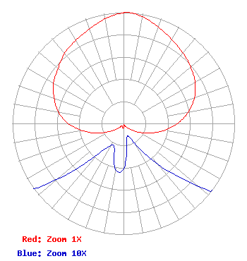 | ||||||||||||||||||
| Azimuth | Ratio | Azimuth | Ratio | Azimuth | Ratio | Azimuth | Ratio | ||||||||||||
| 0 | 0.996 | 3 | 1.000 | 10 | 0.975 | 20 | 0.922 | ||||||||||||
| 30 | 0.871 | 40 | 0.829 | 50 | 0.788 | 60 | 0.743 | ||||||||||||
| 70 | 0.680 | 80 | 0.594 | 90 | 0.487 | 100 | 0.370 | ||||||||||||
| 110 | 0.252 | 120 | 0.156 | 130 | 0.088 | 140 | 0.048 | ||||||||||||
| 150 | 0.022 | 160 | 0.012 | 170 | 0.017 | 180 | 0.041 | ||||||||||||
| 190 | 0.042 | 200 | 0.024 | 210 | 0.023 | 220 | 0.037 | ||||||||||||
| 230 | 0.079 | 240 | 0.147 | 250 | 0.257 | 260 | 0.374 | ||||||||||||
| 270 | 0.499 | 280 | 0.595 | 290 | 0.664 | 300 | 0.727 | ||||||||||||
| 310 | 0.768 | 320 | 0.824 | 330 | 0.862 | 340 | 0.903 | ||||||||||||
| 350 | 0.956 | ||||||||||||||||||
Structure Registration Number 1240386 [ASR Heights Differ from KXBN-FM1 Application] Structure Type: LTOWER Registered To: American Towers LLC Structure Address: Webb Hill Hillrise Dr. (210222) Saint George, UT County Name: Washington County ASR Issued: 11/21/2022 Date Built: 03/23/2004 Site Elevation: 953.7 m (3129 ft.) Structure Height: 30.5 m (100 ft.) Height Overall: 33.5 m (110 ft.) Overall Height AMSL: 987.2 m (3239 ft.) FAA Determination: 11/07/2022 FAA Study #: 2022-ANM-6507-OE Paint & Light FAA Chapters: NONE PRIOR STUDY 2015-ANM-2841-OE 37-03-49.2 N 113-34-27.9 W (NAD 83) 37-03-49.3 N 113-34-25.1 W (Converted to NAD 27) |
1 Manhattanville Road Suite 202 Purchase, NY 10577 Phone: 203-861-0900 Limited Liability Company | Date: 06/04/2009 Application Certifier CCR-ST. GEORGE IV, LLC 501 South Cherry Street Suite 480 Denver, CO 80246 Applicant CLARENCE M BEVERAGE Communications Technologies, Inc. P.o. Box 1130 Marlton, NJ 08053 BROADCAST ENGINEERING CONSULTANT HOWARD LIBERMAN Drinker Biddle & Reath Llp 1500 K Street, Nw Suite 1100 Washington, DC 20005 | |||||||||||||||||