
FCCInfo.com
A Service of Cavell, Mertz & Associates, Inc.
(855) FCC-INFO
|
|
W264BW from 07/29/2004 |
|
|
||||||||||||||||
|
|
W264BW Channel: 264D 100.7 MHz Norwood, Ohio Service: FX - A translator or application for a translator. Facility ID: 139210 Fac. Service: FX Programming Delivery Method: Unspecified Status: License Application Accepted: 01/27/2012 Application Granted: 03/09/2012 File Number: BLFT-20120127AJE License Expires: 00/00/0000 Prefix Type: This is a license for a translator Application Type: License To Cover FCC Website Links: LMS Facility Details This Application CDBS Application Other W264BW Applications Other W264BW Applications in CDBS Including Superseded Applications Mailing Address Correspondence for W264BW Correspondence related to application BLFT-20120127AJE Service Contour - Open Street Map or USGS Map (60 dBu) Service Contour - KML / Google Earth (60 dBu) Class: D, A Noncommercial educational operating with no more than 10W Site Location: 39-06-59.0 N 84-30-07.0 W (NAD 83) Site Location: 39-06-58.8 N 84-30-07.2 W (Converted to NAD 27) Effective Radiated Power: 0.25 kW Transmitter Output Power: 0.238 kW Antenna Center HAAT: 235.7 m Horiz.; 0 m Vert. Antenna Center AMSL: 450 m (1476 ft.) Antenna Center HAG: 213 m (699 ft.) Site Elevation: 237 m. (778 ft.) Height Overall*: 295 m (968 ft.) (* As Filed In This Application, may differ from ASR Data, Below.) Directional Antenna Antenna Make/Model: None Antenna ID: 107137 Polarization:
| ||||||||||||||||||
| Antenna Data for Antenna Id: 107137 W264BW FX File: BLFT-20120127AJE None - Service: FX | 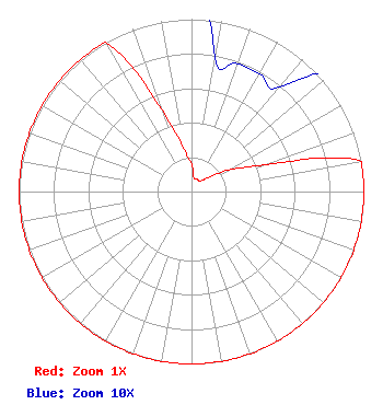 | ||||||||||||||||||
| Azimuth | Ratio | Azimuth | Ratio | Azimuth | Ratio | Azimuth | Ratio | ||||||||||||
| 0 | 0.158 | 10 | 0.079 | 20 | 0.079 | 30 | 0.079 | ||||||||||||
| 40 | 0.079 | 50 | 0.125 | 60 | 0.251 | 70 | 0.457 | ||||||||||||
| 80 | 1.000 | 90 | 1.000 | 100 | 1.000 | 110 | 1.000 | ||||||||||||
| 120 | 1.000 | 130 | 1.000 | 140 | 1.000 | 150 | 1.000 | ||||||||||||
| 160 | 1.000 | 170 | 1.000 | 180 | 1.000 | 190 | 1.000 | ||||||||||||
| 200 | 1.000 | 210 | 1.000 | 220 | 1.000 | 230 | 1.000 | ||||||||||||
| 240 | 1.000 | 250 | 1.000 | 260 | 1.000 | 270 | 1.000 | ||||||||||||
| 280 | 1.000 | 290 | 1.000 | 300 | 1.000 | 310 | 1.000 | ||||||||||||
| 320 | 1.000 | 330 | 1.000 | 340 | 0.501 | 350 | 0.251 | ||||||||||||
Structure Registration Number 1019014 [ASR Heights Differ from W264BW Application] Structure Type: TOWER Registered To: Vertical Bridge CC FM, LLC Structure Address: 1906 Highland Ave Cincinnati, OH County Name: Hamilton County ASR Issued: 11/08/2018 Date Built: 10/01/1987 Site Elevation: 236.5 m (776 ft.) Structure Height: 269.8 m (885 ft.) Height Overall: 294.6 m (967 ft.) Overall Height AMSL: 531.1 m (1742 ft.) FAA Determination: 01/03/1997 FAA Study #: 96-AGL-4129-OE FAA Circular #: 70/7460-1J Paint & Light FAA Chapters: 3, 4, 5, 13 39-06-59.0 N 84-30-07.0 W (NAD 83) 39-06-58.8 N 84-30-07.2 W (Converted to NAD 27) |
5700 West Oaks Blvd. Rocklin, CA 95765 Phone: 916-251-1732 | Date: 01/27/2012 Application Certifier EDUCATIONAL MEDIA FOUNDATION 5700 West Oaks Blvd Rocklin, CA 95765 Applicant SAM WALLINGTON 5700 West Oaks Blvd Rocklin, CA 95765 VP OF ENGINEERING KAREN A. ROSS, ESQ Davis Wright Tremaine Llp 1919 Pennslyvania Ave., Nw Suite 800 Washington, DC 20006 | |||||||||||||||||