
FCCInfo.com
A Service of Cavell, Mertz & Associates, Inc.
(855) FCC-INFO
|
|
|
|
|
||||||||||||||||
|
|
WNJP Channel: 203A 88.5 MHz Sussex, New Jersey Service: FM - A full-service FM station or application. Facility ID: 48471 Fac. Service: FM Status: License Application Accepted: 07/29/1998 Application Granted: 04/08/1999 File Number: BLED-19980729KC License Expires: 00/00/0000 Prefix Type: This is a license for a noncommercial educational FM station Application Type: License To Cover FCC Website Links: LMS Facility Details This Application CDBS Application Other WNJP Applications Other WNJP Applications in CDBS Including Superseded Applications Mailing Address Correspondence for WNJP Correspondence related to application BLED-19980729KC Service Contour - Open Street Map or USGS Map (60 dBu) Service Contour - KML / Google Earth (60 dBu) Public Inspection Files Facility Type: NON-COMMERCIAL EDUC. FM Class: A, A Zone I; I-A; or II station; with 0.1kW-6kW ERP and a class contour distance <=28km Site Location: 41-08-37.3 N 74-32-16.6 W (NAD 83) Site Location: 41-08-37.0 N 74-32-18.0 W (Converted to NAD 27) Effective Radiated Power: 0.45 kW Antenna Center HAAT: 194 m (636 ft.) Antenna Center AMSL: 454 m (1490 ft.) Antenna Center HAG: 58 m (190 ft.) Calculated Site Elevation: 396 m. (1299 ft.) Height Overall*: 61 m (200 ft.) (* As Filed In This Application, may differ from ASR Data, Below.) Directional Antenna Antenna Make/Model: Oddball; usually designed by Applicant ODD910319MD Antenna ID: 14209 Polarization: | ||||||||||||||||||
| Antenna Data for Antenna Id: 14209 WNJP FM File: BLED-19980729KC Oddball; usually designed by Applicant - ODD910319MD Service: FM | 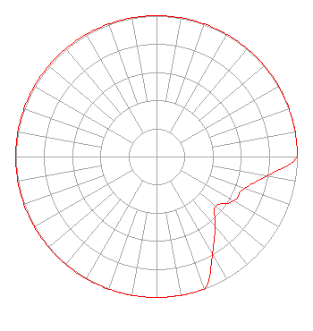 | ||||||||||||||||||
| Azimuth | Ratio | Azimuth | Ratio | Azimuth | Ratio | Azimuth | Ratio | ||||||||||||
| 0 | 1.000 | 10 | 1.000 | 20 | 1.000 | 30 | 1.000 | ||||||||||||
| 40 | 1.000 | 50 | 1.000 | 60 | 1.000 | 70 | 1.000 | ||||||||||||
| 80 | 1.000 | 90 | 1.000 | 100 | 0.795 | 110 | 0.663 | ||||||||||||
| 120 | 0.633 | 130 | 0.548 | 140 | 0.648 | 150 | 0.795 | ||||||||||||
| 160 | 1.000 | 170 | 1.000 | 180 | 1.000 | 190 | 1.000 | ||||||||||||
| 200 | 1.000 | 210 | 1.000 | 220 | 1.000 | 230 | 1.000 | ||||||||||||
| 240 | 1.000 | 250 | 1.000 | 260 | 1.000 | 270 | 1.000 | ||||||||||||
| 280 | 1.000 | 290 | 1.000 | 300 | 1.000 | 310 | 1.000 | ||||||||||||
| 320 | 1.000 | 330 | 1.000 | 340 | 1.000 | 350 | 1.000 | ||||||||||||
Structure Registration Number 1045122 Structure Type: TOWER Registered To: NEW JERSEY PUBLIC BROADCASTING AUTHORITY DBA = NEW JERSEY NETWORK Structure Address: .8 Km Se Of Nj Rt 517 & Sand Pond Rd Int Hardistonville, NJ County Name: Sussex County ASR Issued: 04/27/1998 Date Built: 07/08/1998 Site Elevation: 396 m (1299 ft.) Structure Height: 54.9 m (180 ft.) Height Overall: 61 m (200 ft.) Overall Height AMSL: 457 m (1499 ft.) FAA Determination: 03/27/1998 FAA Study #: 97-AEA-3038-OE Paint & Light FAA Chapters: NONE Removed expiration date from determination. Scenario 1./jjs/case#635066 41-08-37.0 N 74-32-17.0 W (NAD 83) 41-08-36.7 N 74-32-18.4 W (Converted to NAD 27) |
160 Varick Street New York, NY 10013 Phone: 646-829-4400 | Date: 07/29/1998 Application Certifier NEW JERSEY PUBLIC BROADCASTING AUTH. New Jersey Public Broadcasting Authority Cn777 Trenton, NJ 08625 Applicant | |||||||||||||||||
| |||||||||||||||||||